San Diego County Fire Services GIS Integration Project Overview
This project involves the integration of GIS technology for fire services in San Diego County, including the implementation of a geodatabase, pre-incident planning, and collaboration with various public safety agencies. Key tasks include grant funding identification, data migration, and consolidation. The project management structure involves the San Diego County Fire Chiefs Association and regional technology partnerships to ensure smooth execution of milestones and coordination between different zones. Ongoing tasks and future plans include finalizing pre-plan layouts, establishing data access tools, and integrating with other databases for enhanced emergency response capabilities.

Download Presentation

Please find below an Image/Link to download the presentation.
The content on the website is provided AS IS for your information and personal use only. It may not be sold, licensed, or shared on other websites without obtaining consent from the author. Download presentation by click this link. If you encounter any issues during the download, it is possible that the publisher has removed the file from their server.
E N D
Presentation Transcript
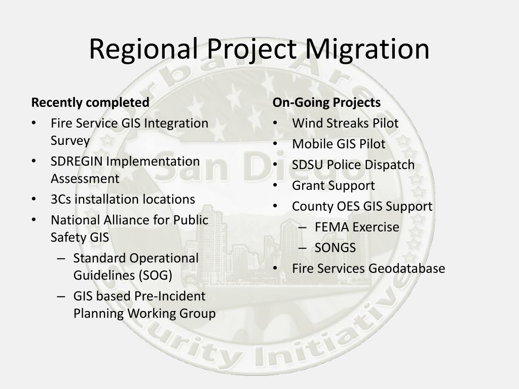
Regional Project Migration Recently completed Fire Service GIS Integration Survey SDREGIN Implementation Assessment 3Cs installation locations National Alliance for Public Safety GIS Standard Operational Guidelines (SOG) GIS based Pre-Incident Planning Working Group On-Going Projects Wind Streaks Pilot Mobile GIS Pilot SDSU Police Dispatch Grant Support County OES GIS Support FEMA Exercise SONGS Fire Services Geodatabase
Fire Services Public Safety Geodatabase Project Management San Diego County Fire Chiefs Association (SDCFCA) Regional Technology Partnership (RTP) Monthly Meetings Executive Leadership. In charge of project logistics and ensuring project milestones are met. Coordinates between zones and manages project. The project manager meets with the Project Working Group and Subcommittees as well as the Steering Committee. This position also reports back to the RTP, SDCFCA, and the SDRGC. Project Manager SDCFCA Comms Monthly Meetings SDRGC North Zone Central Zone Made up of 3 representatives from each zone (GIS, fire operations, and dispatch). The steering committee works directly with the project manager and represents their respective zones. The steering committee looks to the working groups below for technical expertise Steering Committee Monthly Meetings East Zone Metro Zone Project Monthly Meetings Provides technical assistance to the steering committee. These groups are made up of the individuals working on the project in day- to-day operations. They hold monthly meetings which the Project manager runs and brings decisions to be made to the steering committee. Working Group Structure Pre- Plan Subcommittee Wildland Pre- Plan Subcommittee GIS Meetings as needed Subcommittee
Regional Migration Tasks Grant funding identification Geodatabase consolidation and migration* Consolidate Data Model Migrate Landbase to data model Migrate Structure and Wildland pre-plans to data model Documentation Data cleanup and QC SanGIS/Lynx Integration* Road comparison Road edits Incorporate elevation table Develop workflow for monthly update Develop method for no-JPA agencies to access data Finalize Pre-plan layout Strategic plan** Runbook production Planning with agencies Printer contract Create PDF Printing Delivery Centralization of Geodatabase* Establish imagery contract or partnership* Establish link to hazmat database* Data access tools and applications* Tie to RMS* Digital Target Pre-Plans*** * Currently Unfunded ** RTC portion funded Contractor portion unfunded *** Will require on-going funding beyond UASI FY10 funds (Approximately 8,500 structure preplans and 275 wildland preplans are not currently in the FSGDB)
FY09 and FY10 UASI Grants FY09 Hardcopy Fire Run Books $128,215 FY10 Digital Target Hazard Plans (380@ $965ea)(City of SD) Digital Target Hazard Plans (South Zone) Digital Target Hazard Plans (North Zone) Digital Target Hazard Plans of 105 Middle Schools (Region) Digital Target Hazard Plans - generic placeholder (RTTAC/CIPP) $366,700 $175,000 $139,100 $147,000 $ 46,736
FY11 Grant Continue to build, maintain and further standardize a regional Fire Services Geo Database across fire zones to improve response planning and incident management capabilities and functionalities. (Year 1 - $1,398,319 Year 2 - $1,293,479) 1. Centralization efforts to standardize and integrate map features, attributes, and symbols across the SDUA; 2. Data creation for urban and wildland target hazard plans and integration of this data across fire zones to provide emergency responders a common set of pre- planned information; 3. A common operational picture (COP) that implements consistent critical data providing first responders with the ability to share two-way situational awareness at an incident; 4. Maintenance of existing data compiled from previous investment phases; 5. An imagery acquisition contract that will provide region wide aerial imagery to public safety agencies.
UASI Grant Process Objective needs are identified RTP evaluate against UASS priorities Vetted by Committees Presented to the RTP RTP make determination to concur or not UAWG makes final decisions RTP prioritize RTP present to UAWG* SDOHS PM incorporate in submission process as defined by DHS and SDOHS SDOHS determine reallocation requirement based on State 20% SDOHS receive award notification SDOHS allocates grant Periodic status updates by Leads to SDOHS, UAWG and to the RTP Goal monitoring in place Leads take reporting responsibility Grant underway IJ Committee Responsibility *Objective Lead attend as SME RTP Responsibility UAWG Responsibility SDOHS Responsibility
Thank You. Paul Hardwick phardwick@homelandsecurity.sdsu.edu 619-594-8992 Tricia Toomey ttoomey@homelandsecurity.sdsu.edu 619-594-3587