Understanding the Components of GIS for Spatial Planning
A geographic information system (GIS) is a powerful tool for capturing, storing, analyzing, and presenting spatial data. This training program explores the fundamentals of GIS, including software and hardware components, data considerations, and the importance of people and policies in utilizing GIS for effective spatial planning.

Download Presentation

Please find below an Image/Link to download the presentation.
The content on the website is provided AS IS for your information and personal use only. It may not be sold, licensed, or shared on other websites without obtaining consent from the author. Download presentation by click this link. If you encounter any issues during the download, it is possible that the publisher has removed the file from their server.
E N D
Presentation Transcript
Fundamentals of GIS GIS for Spatial Planning Training for Ministry of Transport Mozambique Maputo, Mozambique 2-13 July 2018 Geoinformation and Sectoral Statistics
Understanding GIS A geographic information system (GIS) is a system designed to capture, store, manipulate, analyze, manage, and present spatial or geographic data. GIS is a system that integrates hardware, software, and data for capturing, managing, analyzing, and displaying all forms of geographically referenced information specific data types, data access methods and spatial data analysis methods, visualization of results GIS gives better picture and understanding of the real-world Organizations use GIS to solve problems and improve processes; spatial planning 2
Components of GIS GIS integrates the five key components GIS software and hardware Data People Policy and procedures / methods of implementation 3
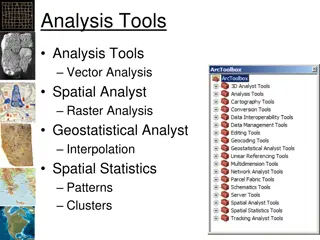
Components of GIS Software and Hardware: Hardware: Computer and associated hardware used for data capturing and dissemination: GPS, digitizers, Scanners, Printers, plotters requirement of GIS software Software: provides the functions and tools needed to store, analyze, and display geographic information Several GIS software are available Free and Open source: QGIS, ILWIS, GRASS GIS, SAGA GIS, MapWindow, etc. Proprietary software: ArcGIS (ESRI ), GeoMedia, MapInfo, SuperGIS, IDRISI, etc. Decision is based on the institution requirement Size of data handled; Cost of the software; Functionalities provided, etc. day-to-day operating procedures and costs; staffing requirements and costs; Maintenance costs; application development and cost user training and costs; etc. 4
Components of GIS Data: is important part of a GIS The most expensive component of a GIS. due to the high costs of data acquisition, especially using remotely sensing earth observation satellites. Building the database also takes a lot of time, and large amount of money. Implementing a Geospatial database requires planning and choosing the right information base for the particular organization/business. application of an 5
Components of GIS The people: transform the geographic/(geo)spatial data in a form usable by every one, the geospatial information. GIS is an interdisciplinary field that requires varied backgrounds of expertise (the people) depending on the applications in use Policies and Institutional frameworks: also important for a functional GIS. The interest and willingness of decision makers to exploit GIS technology, and The organizational setup for collecting spatial data, analyzing, and using the results for planning and implementation 6
Functionalities of GIS GIS Data input, storage and retrieval Data manipulation and analysis Data output/display or visualization Database management 7
Geospatial Data Spatial /Geospatial data is raw data distinguished by the presence of a geographic link; connected to a known place on the earth Represent objects or phenomena with specific location in space Geospatial data is geographically/spatially referenced in some consistent manner, such as by means of latitude and longitude, a national coordinate system, postal codes, or electoral area Geographic information/Geo-information is a specific type of information resulting form interpretation of spatial data/geospatial data 8
Geospatial Data Two important components of geospatial data: geographic position and attributes or properties Geographic position specifies the location of a feature or phenomenon by using a coordinate system (x, y, z) Attributes /non spatial data refer to the various properties of the phenomenon or feature GIS software use database management systems to handle attribute or non-spatial data Provides the link between the geographic position/spatial data and attribute/non-spatial data 9
Geospatial Data Sources GIS handles different data from different sources to produce new information Geospatial data different sources Common data sources: Paper maps, Existing digital data Aerial photographs GPS (Global Systems) Surveying Total Station Imageries from Remote-sensing satellites/ satellites and Laser Scanners, mounted in Aircrafts Drones and UAVs acquired using Positioning instruments, e.g. Earth observation usually 10
Geospatial Data Sources Earth observation data: most commonly used data sources Earth observation is gathering of information about the planet earth Earth observation satellites are satellites specifically designed to observe Earth from space Data from Earth observation satellites/ Remote sensing satellites are processed into images: remote sensing images, satellite imageriesor satellite data 11
Geospatial Data Sources Data collected using GPS can be imported in to a GIS system Global Positioning Systems (GPS) used for data collection and capture GPS is a space-based satellite navigation system that provides location and time information GPS is one of the Global Navigation Satellite (GNSS); Other GNSS include: GLONASS (Russia), Galileo(Europe), Beidou (China) Systems 12
Geospatial Data Sources Existing digital data are available in different formats Features extracted from satellite images using image processing techniques, already existing in different databases Most GIS databases created with data converted from paper maps/ Arial photo Digital maps, datasets and image data are available in the Internet, in different data portals 13
Applications of GIS 80% of all data are related to a geographical position Nearly every problem has some component of location information GIS technology is used by a variety of professionals for a broad range of applications Users: Government offices, research organizations & academia, International/UN agencies, etc. for decisions support, planning, research, etc. 14
Applications of GIS Examples of applications: Water Resource Management Land degradation, Land use and Land cover change Disaster Risk Management Climate Change Mitigation and Adaptation Food Security and Poverty Reduction Health and Telemedicine Land Administration/Cadastre, Socio-Economic mapping, Utility Management, Transport Media (e.g. TV: for Reporting, Marketing, Advertising, etc.) 15