
Midterm Review Mission: Data processing
The responsibilities, history, devices, apps, and techniques involved in data processing, covering tasks like developing apps, training, technical support, and integrating GIS. Learn about the evolution from paper-based data collection to handheld devices and modern applications. Discover how the Ge
2 views • 15 slides

Effective Strategies for A-Level Geography NEA Success
Explore reflections, tools, and ideas for managing the NEA in A-Level Geography. Learn from experienced educators on developing effective practices, supporting students with GIS and Survey tools, and sharing resources for successful completion of NEAs. Engage in discussions on experiences, challenge
0 views • 42 slides

Oklahoma Transportation GIS Cabinet Overview
Oklahoma's Transportation Cabinet consists of three agencies responsible for managing federal aid highways, county roadway data aggregation, Turnpike infrastructure, and aeronautics. The GIS infrastructure includes 18 full-time staff primarily using Esri Enterprise GIS tools for data integration and
1 views • 10 slides

Understanding GPS, GIS, and Remote Sensing: A Comprehensive Overview
Global Positioning System (GPS) is a satellite-based radio positioning system operated by the U.S. Department of Defense. It offers high positioning accuracies, velocity determination, and time accuracy worldwide. The system comprises three segments: Space Segment, Control Segment, and User Segment.
1 views • 25 slides

GIS Data Management in Hydrologic Engineering Center (HEC) Software
Efficiently manage GIS data in HEC software by organizing background shapefiles, saving files in relevant directories, and utilizing relative pathnames. Understand the contents of basin files, GIS directories, and the step-by-step process involved in the delineation of elements within a project.
9 views • 5 slides
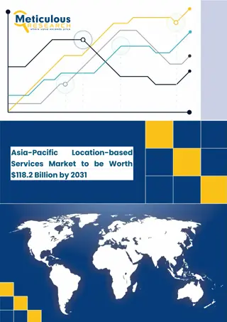
Asia-Pacific Location-based Services Market
Asia-Pacific Location-based Services Market by Component, Technology (GNSS, GPS), Application (Navigation, Mapping & GIS), Location Type, End-use Industry (Transportation & Logistics, Retail & E-commerce), and Geography -Forecast to 2031
1 views • 5 slides

Applications of GIS in Urban Planning and Spatial Operations
This presentation explores the wide range of applications of Geographic Information Systems (GIS) in urban planning, transportation management, utility management, environmental sciences, political science, civil engineering, business, education, real estate, healthcare, and more. GIS facilitates ta
1 views • 19 slides

Introduction to Enterprise Databases for GIS Professionals
Explore the world of enterprise databases through a GIS perspective with a focus on concurrent clients, database administration, creating databases/tables, checking service names, unique features, numeric data types, data type parameters in ArcGIS, and character data types. Gain insights into managi
0 views • 52 slides
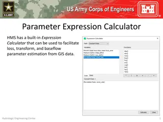
Parameter Expression Calculator for Efficient Parameter Estimation from GIS Data
Parameter Expression Calculator within HEC-HMS offers a convenient tool to estimate loss, transform, and baseflow parameters using GIS data. It includes various options such as Deficit and Constant Loss, Green and Ampt Transform, Mod Clark Transform, Clark Transform, S-Graph, and Linear Reservoir. U
1 views • 5 slides

Evolution of Data Processing Systems in Geographic Information Science
Data processing systems in Geographic Information Science have evolved from manual, analogue methods to advanced software and hardware components. The incorporation of Geographic Information Systems (GIS) has revolutionized the handling and analysis of geo-referenced data, making tasks like data cap
0 views • 20 slides

Understanding Geographic Objects in GIS
Geographic objects play a crucial role in GIS by being easily distinguished and named based on parameters like location, shape, size, and orientation. These objects are studied collectively to understand their interactions and relationships, aiding in tasks such as navigation systems and route optim
2 views • 13 slides

Geographic Information System in Sud Nouvelle Calédonie
The province of Sud Nouvelle Calédonie utilizes an open-source-based Geographic Information System (GIS) to serve its territorial administration, with a focus on applications such as land administration, environment, agriculture, and urban planning. The system is supported by a team of engineers, g
0 views • 15 slides
GIS Application for EPC Asset Damage Assessment post-2009 Tsunami
Utilizing Geographic Information Systems (GIS) for assessing damage to EPC assets after the 2009 Tsunami event. Explore worst-hit and affected areas, query assets, evaluate damage, and derive secondary results for the National Emergency Operations Center (NEOC).
0 views • 8 slides
Guide to GISCI Certification Application Process
Complete your GISCI certification application process successfully by submitting a professional portfolio and passing the Geospatial Core Technical Knowledge Exam. This guide covers all components required, including education, experience, and contributions to the profession. Remember the minimum fo
3 views • 26 slides

Understanding Spatial Analysis in GIS for Effective Decision-Making
Spatial analysis in GIS involves modeling geographic problems, processing data, and exploring results to understand spatial relationships, patterns, and suitability for various purposes. GIS tools offer unique capabilities for handling geographically referenced data, data entry, storage, manipulatio
1 views • 21 slides
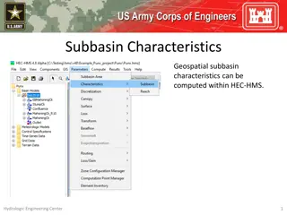
Understanding Subbasin Characteristics in HEC-HMS
Subbasin characteristics play a crucial role in hydrological modeling within HEC-HMS. Before computing these characteristics, the basin model must have georeferenced subbasins in the GIS. Various parameters such as basin slope, relief, elongation ratio, drainage density, and flowpath lengths and slo
0 views • 13 slides

Foundations of Image Sensing and Acquisition in GIS
Understanding the process of image acquisition is crucial for digital image processing in GIS. It involves using physical devices sensitive to different energy bands to convert images into digital form through digitizers. Various methods such as single sensors, sensor strips, and sensor arrays are u
2 views • 16 slides

Gati Shakti National Master Plan for Comprehensive Infrastructure Connectivity
The Gati Shakti National Master Plan aims to integrate various infrastructure projects under one platform for efficient movement of people, goods, and services. It includes mapping economic zones, optimizing logistics, and enhancing connectivity across railways, roads, ports, waterways, airports, an
0 views • 16 slides

District Metered Areas: Creation and Management Overview
District Metered Areas (DMAs) are essential for NRW management in water distribution networks. By isolating and monitoring specific zones, NRW levels can be analyzed effectively, leading to quicker results and reduced costs. Criteria for DMA creation include network knowledge, NRW areas, size consid
0 views • 12 slides
Effective Organisational Measures for NRW Management Teams
Implementing a structured approach to NRW management involves the establishment of a Steering Committee and Task Team. The Steering Committee oversees integration, decision-making, resource allocation, and accountability. The NRW Task Team, led by an experienced caretaker, defines tasks, creates con
0 views • 29 slides
Information Management Roles and Responsibilities in Disaster Response Coordination
The roles and responsibilities of the coordination team in disaster response include key positions such as Cluster Coordinator, Information Manager, GIS Mapping Specialist, and more. National governments play a crucial role in safety, security, and coordination efforts. Exercises are conducted to ag
0 views • 11 slides
Understanding Geodatabases and Creating Them in ArcGIS
Explore the process of creating personal and enterprise geodatabases in ArcGIS for effective spatial planning and GIS applications. Learn step-by-step instructions along with visual aids to create both types of geodatabases.
0 views • 15 slides

Understanding the Components of GIS for Spatial Planning
A geographic information system (GIS) is a powerful tool for capturing, storing, analyzing, and presenting spatial data. This training program explores the fundamentals of GIS, including software and hardware components, data considerations, and the importance of people and policies in utilizing GIS
4 views • 16 slides
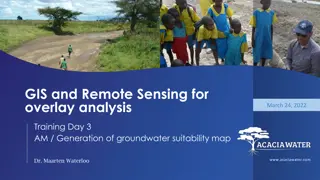
Groundwater Suitability Mapping Training Overview
The training program focuses on GIS and Remote Sensing for overlay analysis, with an emphasis on generating groundwater suitability maps. Dr. Maarten Waterloo leads the session, covering topics like data processing, automation, and sensitivity analysis. The program includes hands-on activities and e
0 views • 14 slides

Cape Cod Stormwater Grant Updates & Municipal Assistance Program
This document provides comprehensive details on the Cape Cod Stormwater Grant Updates, DLTA MS4 Permit Compliance Assistance, and Municipal Assistance Program. It covers grant tasks, program components, GIS mapping assistance, Geospatial Tech Assistance, and various initiatives aimed at improving st
0 views • 19 slides

Enhancing Fiji Police Operations with GIS Implementation
The Fiji Police Force is integrating Geographic Information Systems (GIS) to enhance policing operations through improved situational awareness, crime trend analysis, resource deployment, and cost savings. By investing in GIS technology, the force aims to optimize efficiency, decision-making, and ov
1 views • 17 slides

GIS Data Models for Spatial Planning Training in Maputo, Mozambique
Explore the concepts of GIS data models including vector vs. raster, spatial relationships, spatial operations, and representation of real-world entities in a spatial database. Understand how spatial data models are used to manipulate spatially-referenced information and define the spatial location
1 views • 32 slides

Pacific Climate Change Centre Seminar on GIS and FOSS4G
The Pacific Climate Change Centre in Apia organized a seminar focusing on the importance of GIS and FOSS4G technology. The event included discussions on open GIS data, user group meetings, and keynote speakers. Various local hubs from the Pacific region were involved in the event, showcasing the gro
0 views • 5 slides
Enhancing Coastal Spatial Systems and Database Management for R2R Investments
This presentation delves into the enhancement and training of national GIS/Data Practitioners on R2R coastal spatial systems, governance, and socioeconomic baseline assessments. It explores the use of EGS and DPSIR approaches, along with the integration of existing databases for future R2R investmen
0 views • 4 slides

Future Directions for GIS in Samoa
Enhancing GIS practices in Samoa involves establishing a Samoa GIS User Group, improving spatial data management, developing a national spatial data infrastructure framework, and implementing GIS applications in various sectors like emergency response, public access, and natural resource management.
1 views • 12 slides
Complete Guide to GIS Professional Certification Portfolio Application
Step-by-step guide on completing the GIS professional certification application process, including submission of a portfolio and passing the Geospatial Core Technical Knowledge Exam. Key components include education, experience, and contributions to the profession. Tips on documentation, requesting
1 views • 30 slides

GIS and Remote Sensing for Overlay Analysis Training Program
This training program focuses on GIS and remote sensing techniques for overlay analysis, covering topics such as data processing, suitability mapping, sensitivity analysis, and introduction to Python. The program includes practical sessions on QGIS, lithology, land use, recharge, TWI, and more. Part
1 views • 24 slides

Wetland Prediction Model Assessment in GIS Pilot Study for Kinston Bypass
Wetland Prediction Model Assessment was conducted in a GIS pilot study for the Kinston Bypass project in Lenoir County. The goal was to streamline project delivery through GIS resources. The study focused on Corridor 36, assessing various wetland types over a vast area using statistical and spatial
0 views • 16 slides

Integrated Education & Training Technical Assistance: Building Effective Training Objectives
In this session, the focus is on creating a single set of learning objectives for an Integrated Education & Training program. The importance of measurable training objectives and their role in achieving program goals are discussed. Tips are shared on enhancing training effectiveness, emphasizing wor
0 views • 23 slides

Understanding Land Records and Surveying Practices
Explore topics such as re-locating section corners, working with corner data in GIS, and the importance of accurate survey control in managing GIS systems. Learn about the challenges surveyors face in maintaining section corners and the significance of finding original markers. Discover educational
0 views • 17 slides
GIS Emergency Handbook for DeWitt County Chemical Facilities
The GIS Emergency Handbook project addresses the risks posed by storing Extremely Hazardous Substances (EHS) in DeWitt County by providing vital information to first responders in an easily accessible format. The handbook includes details on chemicals, contacts, and facility information to aid in em
0 views • 18 slides
Oil Pollution GIS for the Wider Caribbean Region by RAC-REMPEITC
Utilizing GIS technology, RAC-REMPEITC focuses on preparedness and response to oil pollution in the Caribbean region. The initiative involves early warning systems, detection, decision-making, coordination, equipment location, remote sensing, modeling, and international support to protect the marine
0 views • 15 slides

Linking BIM and GIS Standard Ontologies with Linked Data
Introduction to the need for seamless data interpretation between Building Information Model (BIM) and Geographic Information System (GIS), focusing on aligning BIM and GIS standard ontologies for semantic interoperability. Addressing the challenges of data interoperability layers and the characteri
0 views • 15 slides

Understanding GIS Data Collection and Sources
Exploring various data sources for GIS projects, this information discusses the importance of data collection, different types of data (primary, secondary, administrative records), formats (digital, hardcopy), and the value of spatial data. Emphasizing the significance of in-house data and major GIS
0 views • 35 slides

GIS Data Preparation and Joining in ArcGIS
Learn the step-by-step process of preparing and joining data in ArcGIS for mapping projects. From eliminating unnecessary fields in Excel to loading and joining data in GIS, this guide provides detailed instructions to ensure accurate data representation. Exporting the finalized data allows users to
0 views • 9 slides