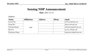
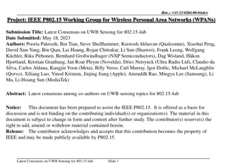
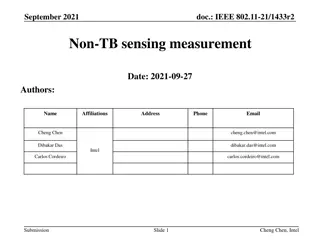
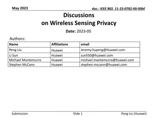
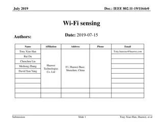
Enhancing Weather Security with GOES-R and JPSS Remote Sensing
Explore how to access, use, and apply GOES-R and JPSS satellite data to address forecasting challenges, mitigate environmental disasters, and make data-driven decisions. Join the virtual event on February 16 & 17, 2022, to learn from experts and participate in hands-on exercises and case studies.

Download Presentation

Please find below an Image/Link to download the presentation.
The content on the website is provided AS IS for your information and personal use only. It may not be sold, licensed, or shared on other websites without obtaining consent from the author. Download presentation by click this link. If you encounter any issues during the download, it is possible that the publisher has removed the file from their server.
E N D
Presentation Transcript
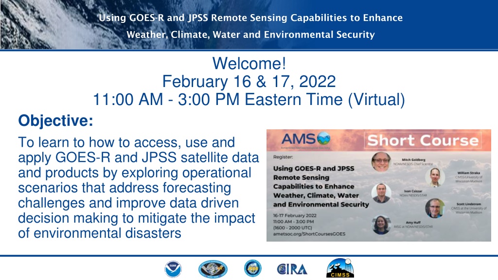
Using GOES-R and JPSS Remote Sensing Capabilities to Enhance Weather, Climate, Water and Environmental Security Welcome! February 16 & 17, 2022 11:00 AM - 3:00 PM Eastern Time (Virtual) Objective: To learn to how to access, use and apply GOES-R and JPSS satellite data and products by exploring operational scenarios that address forecasting challenges and improve data driven decision making to mitigate the impact of environmental disasters
Using GOES-R and JPSS Remote Sensing Capabilities to Enhance Weather, Climate, Water and Environmental Security Reminders: Add your questions in the chat box and/or go to reactions to raise and lower your hand Same Zoom link, same time, both days
Using GOES-R and JPSS Remote Sensing Capabilities to Enhance Weather, Climate, Water and Environmental Security Day 1 of 2 Time (ET) 11:00-11:10 Introductions of students and presenters, Summary of Planned Activities, discussing both GEO and Polar Gary McWilliams(JPSS), Sherrie Morris (GOES- T) 11:10-12:00 NOAA s role in optimizing the use of satellite information Mitch Goldberg, NESDIS Chief Scientist 12:00-12:40 Introduction to Heavy Precipitation and Flooding Products, Diagnoses and Effects William Straka, CIMSS/University of Wisconsin Madison 12:40-12:50 Break: 10 minutes Session Titles
Using GOES-R and JPSS Remote Sensing Capabilities to Enhance Weather, Climate, Water and Environmental Security Day 1 of 2 continued Time (ET) 12:50-13:50 Hands On exercises of Heavy Precipitation and Flooding Products Scott Lindstrom, CIMSS at the University of Wisconsin-Madison 13:40-14:00 Break: 10 minutes 14:00-14:50 Hands-On Guided Analyses of Case Study Scott Lindstrom, CIMSS at the University of Wisconsin-Madison 14:50-15:00 Question & Answer, preparation for Day 2 Session Titles
Using GOES-R and JPSS Remote Sensing Capabilities to Enhance Weather, Climate, Water and Environmental Security
Using GOES-R and JPSS Remote Sensing Capabilities to Enhance Weather, Climate, Water and Environmental Security Dr. Mitch Goldberg is the NOAA Senior Scientist for Environmental Satellites. Dr. Goldberg serves as an expert and lead representative of the NOAA/NESDIS science and user communities and coordinates NESDIS applied science. William Straka is a researcher with the Cooperative Institute for Meteorological Satellite Studies (CIMSS). Currently, he focuses on the utilization of the Day Night Band as well as interacting with the US NWS as well as FEMA, IPNE (Brazil) and several agencies within the United Nations regarding the distribution and utilization of the NOAA LEO/GEO Flood Product as other US satellite products for disaster monitoring and response. Scott Lindstrom is an Information Technologist and trainer at the Cooperative Institute for Meteorological Satellite Studies (CIMSS) at the University of Wisconsin-Madison. The best part of his job is looking at beautiful satellite imagery every day and describing how its use can help in the forecast process. This is done both in writing on blogs and in training webinars. He holds a B.S. in Meteorology (and one in Computer Science) from Penn State, and an M.S. and Ph.D. in Meteorology from the University of Wisconsin-Madison. Find him on Twitter: @WxSatChat.
Using GOES-R and JPSS Remote Sensing Capabilities to Enhance Weather, Climate, Water and Environmental Security CIRA VISIT Website for Retrieving Presentation Slides: https://rammb.cira.colostate.edu/training/visit/links_and_tutorials/2022_AMS_Satellite_Short_Course.asp Upcoming Launches: GOES T: 1 March 2022 (virtual, Kennedy Space Center) JPSS-2: 30 September (Vandenburg AFB) Future AMS Satellite Applications Short Courses: AMS Committee on Satellite Meteorology, Oceanography and Climatology virtual training on satellite data applications 4 topics to be covered in May, June, and July AMS Short Course on GOES-R and JPSS at the Collective Madison Meeting in Madison, WI on 7 August