Remote Sensing Needs Assessment for Wildland Fire Research
Contributors from various institutions are collaborating to identify and improve remote sensing products to support wildland fire operations, monitoring, and research. Existing and prospective products along with their limitations are explored in phases such as pre-fire, active fire, and post-fire. The discussion also touches on spatial analysis, data inputs for wildfire growth prediction, and potential improvements using alternative data sources.

Download Presentation

Please find below an Image/Link to download the presentation.
The content on the website is provided AS IS for your information and personal use only. It may not be sold, licensed, or shared on other websites without obtaining consent from the author. Download presentation by click this link. If you encounter any issues during the download, it is possible that the publisher has removed the file from their server.
E N D
Presentation Transcript
Remote Sensing Needs Assessment Supporting Wildland Fire Research, Monitoring and Operations Contributors in alphabetical order: Matthew Dickinson, USFS Nancy French, Michigan Tech University Everett Hinkley, USFS Charles Ichoku, NASA Josh Johnston, Natural Resources Canada Wilfrid Schroeder, University of Maryland
Background and Objectives Everett - untapped potential for public products derived from classified data to support needs of wildland fire operations, monitoring, and research The remote sensing side needs to know specific product requirements to be developed through a collaborative needs- assessment process. Objective 1 (this discussion): Identify existing and prospective pre-, active-, and post-fire remote-sensing products: Brainstorm (work in progress!) Identify limitations that could be improved Objective 2 (collaborative across the wall): Propose, evaluate, and develop requirements
Objective 1 Existing/prospective products and their limitations Pre-fire phase: o LANDFIRE fuel and vegetation maps o Soil (SMAP) and live fuel moisture o Tree mortality Ignition / Active-fire phases: o Fire detection (HAWKEYE) o Fire Radiative Power (MODIS, VIIRS, GOES-R, others) o Nighttime wildfire perimeters (NIROPS, FIREHAWK) o Plume height and smoke transport monitoring Post-fire phase: o LANDSAT-derived soils effects (BAER), tree mortality (RAVG), and severity (MTBS)
Objective 1 Existing/prospective products and their limitations Product description Spatial layers of crown base height, tree height, canopy density Use Limitations Means for improvement Active remote sensing, stereo image analysis (Phodar), multispectral Phase: Pre- fire Wildfire growth projection Poorly resolved spatially and inaccurate LANDFIRE nationwide spatial data used as inputs to predict wildfire growth (from WFDSS the Wildland Fire Decision Support System) Fire effects prediction in WFDSS later 1 mile
Objective 1 Existing/prospective products and their limitations Phase: Pre-fire - Tree mortality for fire risk assessment eDaRT (Ecosystem Disturbance and Recovery Tracking) USFS Region 5, LANDSAT-based, time progression (Koltunov and others) Other research products derived from LANDSAT and high-resolution multispectral imagery (e.g., from NASA s AVIRIS to the left) Are improvements possible in future using other data sources?
Objective 1 Existing/prospective products and their limitations Phase: Pre-fire NASA SMAP (Soil Moisture Active Passive) Product description Use Limitation Means for improvement Higher resolution data, redundancy Soil moisture mapping from satellite-borne radar Drought monitoring, live and dead fuel moisture prediction Low resolution, instrument issues Ongoing research mapping foliar moisture using multispectral data (including thermal)
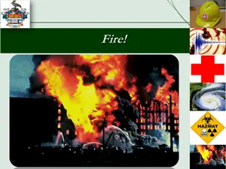
Objective 1 Existing/prospective products and their limitations Phase: ignition Hawkeye wildland fire detection The Hawkeye Fire Detection and Reporting System is a program which uses airborne and space borne remote sensing assets to rapidly detect and report new fire starts within the continental United States. Detected fire starts are relayed to the Ignition Point Database (IgPoint) operated and managed by the Forest Service. Product description Use Limitations Means for improvement ? Wildland fire detection Rapidly detect and report new fire starts Commission errors?
Objective 1 Existing/prospective products and their limitations Phase: Active fire Orbital and geosynchronous satellite fire monitoring of Fire Radiative Power (FRP) Product description FRP from orbital satellites (e.g., MODIS, VIIRS) Use Limitations Objective for improvement Better define sub- pixel fire characteristics and measurement error Means for improvement Provide coincident FRP, flame-front perimeters, and flame-front spread rates Fire detection, US and global fire monitoring, large wildfire operations MWIR signal saturation, sub-pixel flame fronts/fires, off-nadir degradation (e.g., high latitudes, edges of scan) Sub-pixel flame fronts/fires (improved!), off- nadir degradation FRP from geosynchrono us satellites (e.g., GOES-R) US and global fire monitoring Better define sub- pixel fire characteristics and measurement error Provide coincident FRP, flame-front perimeters, and flame-front spread rates
Objective 1 Existing/prospective products and their limitations Phase: Active fire Firehawk and NIROPS (USFS National Infrared Operations) nightly wildfire perimeters to support wildfire incidents Firehawk = Aircraft 3 Improvement: new automated daytime progression product based on data underlying Hawkeye? Product description Use Limitations Objective for improvement Means for improvement Wildland fire perimeters at nighttime Wildfire operations support Nighttime only at ~24 hour interval Daytime perimeters, 1-hour repeat during active periods Use Hawkeye data in new ways?
Objective 1 Existing/prospective products and their limitations Phase: Active fire What about plume height and smoke transport monitoring?
Objective 1 Existing/prospective products and their limitations Phase: Post fire Fire effects (soils, trees, severity) monitoring for US: Burned Area Emergency Response (BAER) Rapid Assessment of Vegetation Condition after Wildfire (RAVG) Monitoring Trends in Burn Severity (MTBS) LANDSAT 30m data esp. contrast between NIR and MWIR highlights greenness change Delivery schedule: BAER days after incident RAVG weeks to months after incident MTBS following year
Unburned/low Low Moderate High Increased greenness Mask MTBS fire severity product
Objective 1 Existing/prospective products and their limitations Phase: Post fire Fire effects (soils, trees, severity) monitoring for US: Burned Area Emergency Response (BAER) Rapid Assessment of Vegetation Condition after Wildfire (RAVG) Monitoring Trends in Burn Severity (MTBS) Product Use downsides Objective for improvement Fill in gaps caused by low reimage frequency/cloud issues, associate severity with fire behavior at similar scale Means for improvement Coincident FRP, flame-front perimeters, flame-front spread rates, more cloud- free imaging BAER, RAVG, MTBS US wildfire effects monitoring to guide response and monitor LANDSAT re-imaging frequency is long (~18 days), cloud free problematic, no associated fire behavior information at similar resolution
Objective 2 Propose, evaluate, and develop requirements Avenues for improving existing products and developing new products: 1. New uses of existing public data 2. New uses of existing non-public data 3. Development of future platforms and sensors Requirements guided by needs assessment My view: #2 can t advance much except collaboratively and iteratively between the public and non-public sides (with knowledgeable users being able to join in non-public discussion)
Upcoming Research Projects As Testbeds for Solutions Team/Project Description Timing Information needs Peak burning period crown fire spread rates & spotting behavior Means for improvement Use Hawkeye data in a new way? Evaluating effects of heavy tree mortality on western (esp. Sierra Nevada/USFS Region 5) wildfire behavior Fire season 2017 and beyond Fire Behavior Assessment Team (FBAT) FIREChem/FIREX Smoke transport and chemistry measurements on wildfires and prescribed fires in forest, rangeland, grassland, & cropland Fire season 2019 Peak burning period flame front spread rates and FRP Use Hawkeye data in a new way? Fire and Smoke Model Evaluation Experiment (FASMEE) Prescribed fire coordinated measurements project 2019 2021 Flame front spread rates and FRP Use Hawkeye data in a new way?
Opportunistic Research Projects As Testbeds for Solutions Generally: data for fire model evaluation Data-driven fire modeling (data assimilation) Team/Project Description Timing Information needs Means for improvement Coupled Atmosphere- Wildland Fire Environment Model (CAWFE), other WRF-based activities Data-driven fire modeling that combines model- based forecasting with periodic evaluation/correction against data Fire season 2017 and beyond (in coordination with research group) Fire perimeters & peak burning period crown fire spread rates Use Hawkeye data in a new way?
Summary/Discussion Phase Product (existing or potential) Need Pre-fire Upgrading LANDFIRE fuel structure layers Higher resolution passive and active Pre-fire Soil moisture Higher resolution active Pre-fire Live fuel moisture and tree mortality High resolution multispectral Ignition Fire detection TBD Active-fire FRP mapping Higher time and spatial resolution Active-fire Fire perimeters Daytime perimeters and fire spread TBD Active-fire Plume and smoke Post-fire LANDSAT-derived soil, tree, and severity maps Associated fire behavior information, more options for cloud-free imagery