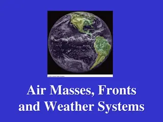
Understanding Air Masses, Fronts, and Severe Weather in Earth Science

In Chapter 20 of Earth Science, we delve into the dynamics of air masses, fronts, and severe weather. Meteorologists study the movement and characteristics of air masses to predict weather changes. Air masses, defined by their temperature and humidity, interact at fronts, leading to precipitation and storms. Warm fronts and cold fronts mark the transitions between different air masses and often signify changing weather conditions. Severe weather phenomena, such as winter storms, highlight the impactful outcomes when air masses clash. This chapter provides essential knowledge for understanding weather patterns and forecasting.

Download Presentation

Please find below an Image/Link to download the presentation.
The content on the website is provided AS IS for your information and personal use only. It may not be sold, licensed, or shared on other websites without obtaining consent from the author. Download presentation by click this link. If you encounter any issues during the download, it is possible that the publisher has removed the file from their server.
E N D
Presentation Transcript
EARTH SCIENCE CHAPTER 20: STORMS AND WEATHER PREDICTION Lesson 20A: Air Masses and Fronts Lesson 20B: Severe Weather Lesson 20C: Weather Forecasts
20A: Air Masses and Fronts Weather changes because air is always moving. Forecasters watch air masses movement to predict and report weather. Air mass huge body of air in the troposphere with similar temperature and humidity throughout Air masses can cover thousands of square kilometers and extend vertically several kilometers When air masses meet (do not mix), precipitation and storms can form Air mases gain strength properties from the ground beneath them or sea beneath it. Air masses take on humidity and temperature of areas called source regions (land or ocean). Normally not windy areas. (air mass must remain in contact with earth s surface long enough to take on humidity and temp) Meteorologist classify air masses by the amount of temp and humidity they obtain from source regions Five source region categories recognized by Meteorologist: 1) Continental artic (cA) 2) Continental polar (cP) 3) Continental tropical (cT) 4) Maritime polar (mP) 5) Maritime tropical (mT) *two-letter symbols identify air masses on weather maps and weather reports Air masses carry their source regions weather when they move.
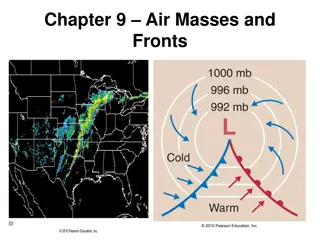
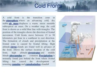
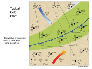
Meteorologist label an air mass by comparing its temperature to the temperature of the ground below it (the area it moves over). Warm air masses are warmer than the ground, cold air masses are cooler. Front the boundary where at least two different air masses meet. Fronts form because of the difference in density between the two air masses. Fronts are where most storms form. Moving fronts are named by the kind of air mass replacing the existing one over a region. If warn air mass over takes cold air mass, it is a warm front. Indications of a warm front (observer on the ground) a) Cool temperatures suddenly rise b) Pressure slowly decreases and then remains steady c) Winds often shift from the southeasterly to the southwesterly direction in North America d) Dew point slowly rises and then is steady If cold air mass replaces a warm air mass, it is a cold front Indications of a cold front (observer on the ground) a) Warm temperatures suddenly drop b) Pressure rises quickly and then more slowly c) Winds begin southwest to southeast in North America, but quickly swing to the northwest as the front passes, often with gusts d) Dew point suddenly falls and then drops slowly
20B: Severe Weather 20B: Severe Weather When air masses meet they can cause storms When air masses meet they can cause storms Storms Storms a severe weather disturbance involving high winds, a severe weather disturbance involving high winds, heavy precipitation, and other conditions, such as lightning or heavy precipitation, and other conditions, such as lightning or low temperatures low temperatures Four types of severe weather: Four types of severe weather: 1) 1) Winter storms Winter storms storm that brings heavy snow or sleet, high storm that brings heavy snow or sleet, high winds, and/or unusually cold weather. winds, and/or unusually cold weather. * *wintery mix wintery mix periods of rain, melting ice, and snow. If all three periods of rain, melting ice, and snow. If all three fall at the same time it I called sleet. fall at the same time it I called sleet. *For snow to fall, water vapor must form crystals by deposition *For snow to fall, water vapor must form crystals by deposition within cold strata in the lower atmosphere. For snow to within cold strata in the lower atmosphere. For snow to accumulate on the ground, air mass must be below freezing (so accumulate on the ground, air mass must be below freezing (so that it wont melt as it falls). Snow piles up when the ground or that it wont melt as it falls). Snow piles up when the ground or other surfaces are below freezing other surfaces are below freezing *Hazards of winter storms: *Hazards of winter storms: a)Road conditions b) heavy snow can break tree limbs, making a)Road conditions b) heavy snow can break tree limbs, making it dangerous to be near trees. Limbs can bring down power it dangerous to be near trees. Limbs can bring down power lines, or damage structures lines, or damage structures *Ice storms do more damage than snow storms *Ice storms do more damage than snow storms
2) Thunderstorms bring thunder, lightning, and heavy precipitation *usually occur during summer. *can occur winter months on the edge of cold fronts *squall line string of thunderstorms along a cold front system *On warm days, air near the surface heats rapidly and rises by convection. This air reaches its dew point and water vapor condenses, this condensation form a cumulonimbus (thunderhead). When large storms approach, rain is often preceded by a blast of cooler air called a gust front. *Hazards of thunderstorms: a) Wind gusts b) Hail c) Lightning electrical discharge either between clouds or between a cloud and the ground. 3) Tornadoes destructive, localized, rapidly rotation cyclonic windstorm forming a funnel; usually associated with a special cumulonimbus called a supercell *Tornadoes are most common and destructive in the southern and central sections of the United States (Tornado Alley) *Hazards of Tornadoes: *1000 tornadoes strike the U.S. each year, killing 80, injuring 1500. *Tornado strength is rated on the Fujita-Pearson Scale EF0 65-85 MPH, EF1 86-110 MPH, EF2 111-135 MPH, EF3 136-165 MPH, EF4 166-200 MPH, EF5 - >200 MPH
4) 4) Hurricanes Hurricanes Hurricanes Hurricanes largest storms of all. Immense cyclonic largest storms of all. Immense cyclonic windstorm that forms over tropical or subtropical oceans; windstorm that forms over tropical or subtropical oceans; hazardous to ships at sea and extremely damaging if it moves hazardous to ships at sea and extremely damaging if it moves over land (typhoon or cyclone) over land (typhoon or cyclone) Tropical storm Tropical storm strong cyclonic storm with winds of at least strong cyclonic storm with winds of at least 63 km/h (39 mi/h). Strengthening tropical storms can develop 63 km/h (39 mi/h). Strengthening tropical storms can develop into hurricanes into hurricanes Saffir Saffir- -Simpson Hurricane Categories: Simpson Hurricane Categories: *Category 1 *Category 1 79 79- -95 M/H 95 M/H *Category 2 *Category 2 96 96- -110 M/H 110 M/H *Category 3 *Category 3 111 111- -130 M/H 130 M/H *Category 4 *Category 4 131 131- -155 M/H 155 M/H *Category 5 *Category 5 - - 156 M/H 156 M/H Eye Eye low low- -pressure center of a hurricane containing relatively pressure center of a hurricane containing relatively clear, calm, rising air. The eye usually has light winds, low clear, calm, rising air. The eye usually has light winds, low precipitation, and low pressure precipitation, and low pressure Storm Surge Storm Surge higher than normal water level caused by higher than normal water level caused by seawater flowing toward the lower air pressure under a seawater flowing toward the lower air pressure under a hurricane hurricane
20C: Weather Forecasts Station model symbolic representation of data from a weather station on a weather map. Each number and symbol, and their locations in the model, provide specific weather information. A single station does not provide much help for the big picture. It requires many station models to see weather patterns emerge National Weather Service has many centers that form a network to analyze reports. The Hydrometeorologist Prediction Center (HPC) located in Washington creates many of the weather maps used in this process. These maps are used by meteorologist to predict weather daily. HPC maps plot combinations of temperature, pressure, wind, centers of high and low pressure, cloud cover, fronts, precipitation, or storm activity. The combinations of these pieces allow future weather prediction. Isotherm lines of equal temperature Isobars lines of equal pressure Isohyet lines connecting places with equal rainfall Synoptic weather maps weather map that presents a summary or synopsis of weather data for a given time frame Four synoptic weather maps: 1) Surface weather map 2) Highest and Lowest Temperature map 3) Precipitation Areas and Amounts map 4) 500 Milibar Height Contours map


 Thunderstorms – bring thunder, lightning, and heavy")
")