
Tower Hamlets Annual Resident Survey 2023 Results Overview
The Tower Hamlets Annual Resident Survey 2023 provides insights into residents' feedback and opinions on various aspects. Conducted by MEL Research, the survey aims to capture a representative sample of residents in Tower Hamlets, highlighting statistical significance and methodology details. The su
1 views • 32 slides
Guidelines and Recommendations for Hydrographic Offices CATZOC Allocation
The report highlights guidelines for Hydrographic Offices to allocate CATZOC values based on minimum bathymetry standards, ZOC categories, and best practices from various national methodologies. It covers position accuracy, depth accuracy, and seafloor coverage criteria. The allocation is primarily
6 views • 18 slides
Instructions for Completing GLAAS Country Survey 2024
In Module 4 of GLAAS information, you will find guidance on filling out the country survey for GLAAS 2024. Topics covered include an overview of the survey package, instructions for completing the survey either as a PDF or online (eGLAAS), general tips for successful completion, advice on governance
4 views • 42 slides
Fiji Hydrographic Office Overview
Lieutenant Jervis Robinson, a Senior Hydrographic Surveyor at the Fiji Hydrographic Office, provided insights into the roles and responsibilities of the office in collecting, processing, and disseminating georeferenced data related to maritime navigation, marine resources, and environmental preserva
1 views • 23 slides
South West Pacific Hydrographic Commission Report 2018
The South West Pacific Hydrographic Commission (SWPHC) report to IRCC highlights their activities, meetings, and capacity building efforts. The commission, chaired by Australia, focuses on hydrographic governance and capacity building in the Pacific region. With various member and observer states in
0 views • 11 slides
Hydrographic Development Progress in Papua New Guinea
The National Maritime Safety Authority (NMSA) in Papua New Guinea has made significant strides in hydrographic development, including expanding staff, initiating capacity-building programs, conducting surveys, charting efforts, and enhancing Maritime Safety Information (MSI) capabilities. Challenges
0 views • 6 slides
Overview of the 35th Meeting of the North Sea Hydrographic Commission and IHO Secretariat Operations
The 35th Meeting of the North Sea Hydrographic Commission held in Reykjavik, Iceland, from 5-7 April 2022, discussed council matters, work program items, and the IHO Secretariat's role. The IHO is composed of 97 member states organized into regional commissions, with activities aligned to a three-ye
4 views • 13 slides
Southern African and Islands Hydrographic Commission Meeting Report
The report discusses the progress, challenges, and achievements of the Southern African and Islands Hydrographic Commission, including issues with administrative arrangements, integration in the International Hydrographic Organization, and upcoming projects. It also highlights activities such as sur
0 views • 11 slides
Overview of Non-Point Survey Training and Updates
This content provides detailed information and resources related to the Non-Point Survey Training Program, including modules, topics covered, process flow for completing the survey, reasons for conducting the survey, and changes made in the survey since the 2014 inventory. It also addresses common i
1 views • 13 slides
Hydrographic Progress in Antarctica: Insights from HCA-15 Report
France's national report at the HCA-15 conference in Niteroi, Brazil, highlighted survey and charting advancements in Antarctica post HCA-14, including new publications, areas surveyed, and the impact of the Polar Code. The report also addressed the status of relations with other organizations, focu
0 views • 10 slides
Italian Navy Hydrographic Institute's Capacity Building Activities
Captain Lamberto Orlando Lamberti, Deputy Director of the Italian Navy Hydrographic Institute, presented on various capacity building initiatives at the 15th Capacity Building Sub-Committee Meeting in Paramaribo. The presentation highlighted Italian contributions, academic education programs, job tr
0 views • 17 slides
Understanding the National Hydrographic Coordinating Committee (NHCC)
Explore the purpose and composition of the NHCC, diving into topics such as hydrographic governance, key references, and the essential role it plays in coordinating efforts within the maritime domain to enhance nautical information services. Discover why an NHCC is crucial, who forms part of it, and
0 views • 11 slides
Italian Navy Hydrographic Institute - Category B Course Programme
Italian Navy Hydrographic Institute offers a Category B Course Programme for Hydrographic Surveyors, providing the necessary knowledge and skills for tasks aboard survey vessels. The program includes theory classes and practice sessions over 8 months, certified by the International Bureau of Standar
0 views • 22 slides
Safety Survey Readiness for Joint Commission Meeting
A call to action for Joint Commission safety survey readiness with a focus on identifying and mitigating patient and provider safety risks. Highlights include known risks from the 2021 survey findings, Vizient mock survey findings, and the purpose of the upcoming survey to ensure patient and provide
0 views • 18 slides
Understanding Hydrographic Surveying in Geomatics Engineering
Hydrographic surveying is a specialized field within geomatics engineering focused on mapping the water floor to produce nautical charts or bathymetric maps. These surveys play a crucial role in navigation, pipeline routing, cable installation, and more, providing essential data for various applicat
0 views • 19 slides
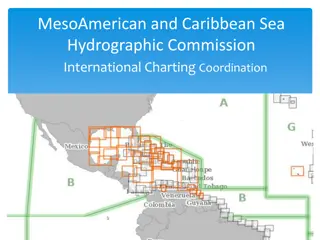
MACHC Hydrographic Commission Updates and Coordination Efforts
The MesoAmerican and Caribbean Sea Hydrographic Commission (MACHC) is actively coordinating efforts to resolve chart overlaps and enhance ENC data in the region. With a focus on ENC progress, work procedures, and boundary extensions, the Commission is working towards seamless charting and updated re
0 views • 21 slides
MACHC Activities and Initiatives Report
The International Hydrographic Organization's (IHO) Inter-Regional Coordination Committee (IRCC) Meso-American and Caribbean Sea Hydrographic Commission (MACHC) has been involved in various activities and initiatives. This includes technical visits, training courses, seminars, and workshops aimed at
0 views • 18 slides
Updates from the 16th Meeting of South West Pacific Hydrographic Commission
The report details the operations of the International Hydrographic Organization and its regional commissions. It discusses the membership eligibility of certain states, coordination of chart production, GIS and database utilization, and the importance of data accuracy. Proposals for harmonizing rep
0 views • 12 slides
Overview of Nordic Hydrographic Commission Activities
The Nordic Hydrographic Commission (NHC) has been actively involved in various initiatives and projects related to hydrography and maritime safety. Their recent meetings have focused on topics such as digital products for the leisure market, S-100 product developments, and new ship route systems in
0 views • 12 slides
Sri Lanka Hydrographic Commission Progress Report
Sri Lanka's National Report to the North Indian Ocean Hydrographic Commission highlights achievements such as publishing Colombo Harbour ENC, launching MSDI web portal, and conducting joint surveys. Challenges include outdated survey data, lack of qualified cartography professionals, and equipment l
0 views • 12 slides
South East Pacific Regional Hydrographic Commission (SEPRHC) Report Summary
The South East Pacific Regional Hydrographic Commission (SEPRHC) chaired by Rear Admiral Jorge Paz Acosta held various meetings and discussed work programs related to hydrographic activities in the region. The commission focused on important action items to enhance coordination and progress in hydro
0 views • 7 slides
New York Statewide Center for Independent Living 2021 Consumer Satisfaction Survey Methodology
The New York Statewide Center for Independent Living conducts an annual Consumer Satisfaction Survey to gather feedback from consumers served by the center. The survey can be conducted online via Survey Monkey or through direct mail. Detailed instructions are provided on the NYSILC website for condu
0 views • 8 slides
Enhancing Hydrographic Services in Palau: A Call for Support
Palau currently lacks a dedicated Hydrographic Office but aims to establish one through the efforts of the PALARIS office. The need for hydrographic surveys in near shore areas, coral reefs, and navigation channels is crucial for various sectors like marine resources, tourism, and maritime industrie
0 views • 4 slides
Annual Report of South West Pacific Hydrographic Commission
The annual report by Samoa, an Associate Member State of the South West Pacific Hydrographic Commission, highlights key achievements, challenges, and progress in hydrographic activities. Main achievements include the endorsement of an MOU with LINZ in 2018 and preparation of H Notes on buoys. Challe
0 views • 7 slides
Hydrographic Survey Training Course in Japan
Hydrographic Survey Training Course (CAT B) is conducted in Japan annually by Japan International Cooperation Agency (JICA) in collaboration with Japan Coast Guard. The course covers theory, techniques, and skills related to hydrographic surveying, with participants gaining hands-on experience throu
0 views • 5 slides
South West Pacific Hydrographic Commission Country Report for Kiribati
Kiribati's country report highlights achievements such as receiving satellite-derived bathymetry datasets, hosting awareness workshops, and pursuing funding for LIDAR surveys. Challenges include limitations in meeting mapping authority standards and a lack of legislative support for hydrographic act
0 views • 13 slides
Hydrographic Survey Report 2018 for the Kingdom of the Netherlands
Detailed report of hydrographic surveys conducted in the Kingdom of the Netherlands in 2018. Includes achievements such as deep-water MBES surveys, results on reef erosion, maritime boundary ratification, and engagement with local data providers. Progress made on offering INSPIRE-compliant web servi
0 views • 10 slides
Netherlands Hydrographic Office Report at 18th MACHC Conference
Detailed overview of the Netherlands Hydrographic Office's responsibilities in the Caribbean, survey policies, new chart updates, MSDI progress in the Caribbean Sea, and other activities. Includes insights on participation in international organizations and initiatives. The report covers various asp
0 views • 10 slides
Hydrographic Achievements and Challenges in Antigua and Barbuda
Antigua and Barbuda reported significant accomplishments in hydrographic developments, including dredging shipping channels, building seawalls, and upgrading cruise berths. However, challenges like individual approaches to development and lack of effective training utilization hinder progress. Futur
0 views • 7 slides
California Public Libraries Survey 2020-2021 Overview
The California Public Libraries Survey for 2020-2021 provides an in-depth look at the state of libraries in California. This webinar covers the survey process, data elements, resources, and the importance of the survey in understanding and meeting community needs. Learn about the National Public Lib
0 views • 25 slides
UKHO Activities and Support in Meso-American and Caribbean Seas
UK Hydrographic Office (UKHO) published its National Report and detailed its activities in chart production, ENC production, paper chart production, publications, support to coastal states, and survey activities in the Meso-American and Caribbean Seas region. The report highlights UKHO's role as the
0 views • 10 slides
European Hydrographic Activities and Marine Data Initiatives
IRCC-9 in Paramaribo discussed the IHO-EU Network Working Group's efforts to monitor and manage hydrographic aspects. The Coastal Mapping project aims to enhance digital mapping in the EU while EMODNet provides access to marine data. Improving cooperation with EU Directorates-General and monitoring
0 views • 8 slides
Hydrographic Dictionary Implementation Overview
The Hydrographic Dictionary (HD) outlined key principles, layout, updating procedures, GI registry, and structure during the 6th EAHC Steering Committee Meeting. It emphasized the unique IHO reference number, terms selection process, and approval mechanisms by HSSC. The procedure for updating terms
0 views • 16 slides
Hydrographic Surveying in Saint Vincent and the Grenadines
Saint Vincent and the Grenadines face challenges in hydrographic surveying due to lack of trained personnel, equipment, and compliance with international obligations. Efforts are being made through regional projects to develop hydrographic services and improve nautical chart production.
0 views • 10 slides
Italian Navy Hydrographic Institute Capacity Building Activities
Italian Navy Hydrographic Institute, under the leadership of Captain Lamberto Orlando Lamberti, conducts a range of academic and training courses as well as projects to enhance hydrographic surveying capabilities. These initiatives include offering high-level courses for Category A and B hydrographi
0 views • 7 slides
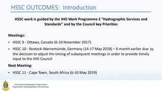
International Hydrographic Organization - HSSC Outcomes and Discussions
The Hydrographic Services and Standards Committee (HSSC) under the International Hydrographic Organization works towards developing and maintaining technical standards for hydrographic information. Recent discussions focus on revising Terms of Reference, initiating Resolutions, and prioritizing key
0 views • 5 slides
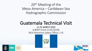
Guatemala Technical Visit - International Hydrographic Organization
The Guatemala Technical Visit organized by the International Hydrographic Organization focused on the achievements and recommendations for enhancing hydrographic survey capabilities in Guatemala, particularly in collaboration with the US Primary Charting Authority. The visit highlighted the importan
0 views • 8 slides
Report on the Work of the IHO for the Period 2012-2016 by the Baltic Sea Hydrographic Commission (BSHC)
The report highlights the achievements of the Baltic Sea Hydrographic Commission (BSHC) during 2012-2016, including joint projects, database provisions, harmonized chart datum, and collaboration efforts. It also addresses the challenges faced by Lithuania as an Associate Member and emphasizes the pr
0 views • 6 slides
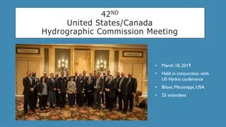
Highlights from the 42nd United States/Canada Hydrographic Commission Meeting
The 42nd United States/Canada Hydrographic Commission Meeting was held in conjunction with the US Hydro conference in Biloxi, Mississippi, USA. Key highlights included updates on national reports from the USA and Canada, emphasizing cooperation and collaboration in various areas. The meeting discuss
0 views • 14 slides
Proposed IHO Work Programme for 2018
The proposed work programme for 2018 by the International Hydrographic Organization covers various aspects including corporate affairs, priorities for Programme 1 and Programme 2, focusing on hydrographic services and standards. Key priorities include contributing to harmonization efforts, managing
0 views • 13 slides