MACHC Hydrographic Commission Updates and Coordination Efforts
The MesoAmerican and Caribbean Sea Hydrographic Commission (MACHC) is actively coordinating efforts to resolve chart overlaps and enhance ENC data in the region. With a focus on ENC progress, work procedures, and boundary extensions, the Commission is working towards seamless charting and updated regional schemes. Quarterly updates and collaborative work by member states contribute to the efficient management of hydrographic data and the availability of navigational charts.
Download Presentation

Please find below an Image/Link to download the presentation.
The content on the website is provided AS IS for your information and personal use only. It may not be sold, licensed, or shared on other websites without obtaining consent from the author.If you encounter any issues during the download, it is possible that the publisher has removed the file from their server.
You are allowed to download the files provided on this website for personal or commercial use, subject to the condition that they are used lawfully. All files are the property of their respective owners.
The content on the website is provided AS IS for your information and personal use only. It may not be sold, licensed, or shared on other websites without obtaining consent from the author.
E N D
Presentation Transcript
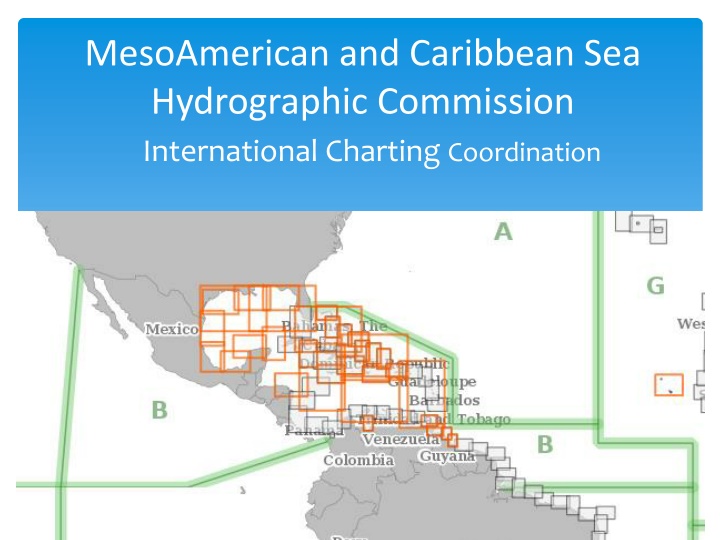
MesoAmerican and Caribbean Sea Hydrographic Commission International Charting Coordination
Presentation Agenda Membership and Work Procedures MICC updates ENC Progress ENC Online Work Plan 2020
Work Procedures Quarterly calls Member states actively work to resolve chart overlaps ENC updates sent to MICC Technical Coordinator Updates for ENC Online Member states actively work to resolve MICC related matters
MICC Updates IC-ENC to send quarterly updates for ENC Online data INT chart coordinator send quarterly updates MACHC Regional ENC scheme proposal update by Columbia
MACHC ENCs Available Total MACHC ENCs 2013-2019 1000 900 800 700 Available ENCs 600 500 400 300 200 100 0 2013 583 2014 665 2015 723 2016 760 2017 820 2018 914 2019 933 Number of ENCs
MACHC ENCs by Usage Band 2018 2019 450 400 350 300 250 200 150 100 50 0 2018 2019 12 34 108 116 283 284 424 53 60 Band 1 12 Band 2 35 Band 3 Band 4 Band 5 Band 6 426
The MACHC ENC boundary . Some years ago a decision was made to extend the boundary to include parts of the Amazon river. Below you can see the highlighted boundary in red. However the IC-ENC coverage maps and all other authoritative boundary data does not reflect this change. This change should be reflected on the IHO and other sites.
ENC Overlap- IC ENC RENC Membersh ip Overlap extent (Kmxkm) (m/square NM) Usage Band ENC 1 Scale ENC 2 Scale ENC 1 EN (ER) ENC 2 EN (ER) ID STATUS RHC ENC 1 ENC 2 PA3AM92 9 173 ACCEPT IC-ENC MACHC CO300023 3 180000 180000 2 (0) 1 (20) 1m x 9.9Km 668 POTENTIAL IC-ENC MACHC VE300600 GB300500 3 180000 90000 3 (0) 8( 6) 2.5 km x 1.7 km 36.54 km x 27.51 km 659 POTENTIAL IC-ENC MACHC VE300600 GB380210 3 180000 90000 3 (0) 9 (1) 31.88 km x 64.42 km 658 POTENTIAL IC-ENC MACHC VE300600 VE300500 3 180000 180000 3 (0) 4 (1) 655 POTENTIAL IC-ENC MACHC VE300700 GB300501 3 180000 90000 1 (0) 7 (0) 48 Km x 80 Km 656 POTENTIAL IC-ENC MACHC VE300700 VE300600 3 180000 180000 1 (0) 2 (1) 168 Km x 21 Km VE re-scheme validated which increases the coverage in the channel south of Grenada expecting clips for the GB cells to be concluded once the verification of VE300700 has been completed
Cruise Ship Port Analysis Summary Update 2015 Cruise Ship Ports Gap Analysis identified 43 ports in MACHC region with no large scale ENC coverage 2016 Two large scale ENC s cover gaps in Cuba and VZ 2017/2018 12 New large scale ENC s cover gaps in VZ, Bahamas, Cuba, St. Vincent & Grenadines, Trinidad; total down to 29 ports from 43
Cruise Ship Ports with Large Scale ENCs Total ports : 92 Not covered : 32 Covered:60
Cruise ship port gaps 2019 Current_ La COUNTRY PORT Informatio Planned_EN Additional Priority Port identified, no planned ENCs band 4, 5 or 6 coverage? Norwegian Cruise No knowledge of a requirement (from cruise company or other user) Also known as Little Stirrup Cay; I am aware that construction has started for a pier and dredging will be taking place. No large scale data available yet. The cruise company may well supply the survey data(?) Is this known as 'Rum Cay'? No knowledge of a requirement (from cruise company or other user) Bahamas Great Stirrup Cay UB 3 Little Stirrup Cay - Royal Caribbean Priority Port identified, no planned ENCs band 4, 5 or 6 coverage? Coco Cay (Little Stirrup Cay) Bahamas UB 3 San Salvador Island (Rum Cay) cruise ship gap analysis Bahamas UB 3 Planned ENCs 5. New lidar survey data received for The Narrows: no knowledge of requirement for ENC for cruise company (remove?) Responsibility shared between US and UK Vicinity of Lighthouse Reef cruise ship gap analysis cruise ship gap analysis cruise ship gap analysis No planned ENCs band 4, 5 or 6 coverage? Belize UB 3 Costa Rica Bahia Coco UB 2 New ENC band 5 (GB51798B) No planned ENCs band 4, 5 or 6 coverage? Costa Rica Puerto de Quepos UB 2 Vicinity of Drake Bay Vicinity of Dos Rios cruise ship gap analysis cruise ship gap analysis cruise ship gap analysis No planned ENCs band 4, 5 or 6 coverage? No planned ENCs band 4, 5 or 6 coverage? No planned ENCs band 4, 5 or 6 coverage? Costa Rica UB 2 Costa Rica UB 3 Costa Rica Drake Bay UB 2
Cruise ship port gaps 2019 Vicinity of Playa Posa Colorado Vicinity of Isla Tortuga Added from cruise ship gap analysis Added from cruise ship gap analysis Added from cruise ship gap analysis Added from cruise ship gap analysis Added from cruise ship gap analysis No planned ENCs band 4, 5 or 6 coverage? No planned ENCs band 4, 5 or 6 coverage? No planned ENCs band 4, 5 or 6 coverage? No planned ENCs band 4, 5 or 6 coverage? No planned ENCs band 4, 5 or 6 coverage? Costa Rica UB 3 Costa Rica UB 3 Costa Rica Herradura Bay UB 3 Costa Rica Potrero Bay UB 2 Costa Rica Culebra Bay UB 2 Band 4 coverage pending IC-ENC validation Nov. 2017 Added from cruise ship gap analysis Added from cruise ship gap analysis Added from cruise ship gap analysis Added from cruise ship gap analysis Added from cruise ship gap analysis Added from cruise ship gap analysis Added from cruise ship gap analysis Cuba Isla de la Juventud UB 3 Planned ENCs band 4 No planned ENCs band 4, 5 or 6 coverage? No planned ENCs band 4, 5 or 6 coverage? Dominican Republic Isla Catalina UB 3 US PCA Boca de Chavon, La Romana Dominican Republic UB 3 US PCA Mexico Isla Carmen UB 2 Planned ENCs band 4 and 5. Mexico Isla Carmen UB 2 Planned ENCs band 4 and 5. Mexico Puerto Escondidio UB 2 Planned ENCs band 4 and 5. Mexico Puerto Agua Verde UB 2 Planned ENCs band 4.
Cruise ship port gaps 2019 Added from cruise ship gap analysis Mexico Isla Partida UB 2 Planned ENCs band 4. Added from cruise ship gap analysis Mexico Isla Espirito Santo UB 2 Planned ENCs band 4. Added from cruise ship gap analysis No planned ENCs band 4, 5 or 6 coverage? Nicaragua Islas del Maiz UB 3 Added from cruise ship gap analysis No planned ENCs band 4, 5 or 6 coverage? Panama Isla de Coiba UB 3 Added from cruise ship gap analysis No planned ENCs band 4, 5 or 6 coverage? Panama Isla Parida UB 3 Added from cruise ship gap analysis No planned ENCs band 4, 5 or 6 coverage? Panama Isla Pacheca UB 3 Added from cruise ship gap analysis No planned ENCs band 4, 5 or 6 coverage? Panama Isla de Coiba Union Island Chatham Bay (Carriacou) UB 3 Saint Vincent and the Grenadines Added from cruise ship gap analysis No planned ENCs band 4, 5 or 6 coverage? New lidar data expected early 2017. UB 3 Saint Vincent and the Grenadines L'Esterre Bay (Carriacou) Added from cruise ship gap analysis UB 5 New Band 5 coverage (GB50795B) Saint Vincent and the Grenadines Added from cruise ship gap analysis Hillsborough UB 5 New Band 5 coverage (GB50795B) P3552 Venezuela Boca Grande Terminal UB 3 Priority Port identified, no planned ENCs band 4, 5 or 6 coverage? Identified through Priority Ports list
INT Charts 49 Produced 33 Schemed Produced:51 Schemed : 33
Schemed INT Charts INT charts approved by ACDS 2019: 4190A, 4190B, 4191, 4182 and 4184
Regional ENC Scheme real benefit for the navigator needs (the opportunity to redesign and correct the ENCs before facing the challenge of the S-101 standard ) produced on a homogeneous compilation scale (1 / 180 000 or 1 / 90 000, in accordance with S-11 Part B)
Requests to the MACHC Approve the Work Plan Endorse the progress on ENC production throughout the region Encourage MACHC ENC Online participation Encourage to provide CATZOC information to RENC Work towards approval 0f the standardized regional ENC scheme Encourage S-100 test beds Encourage S-122 Marine protected areas and S-123 Marine Radio services dataset contribution Encourage Product Specification development participation Note the WEND and IRCC Updates
Thank You Thank You
