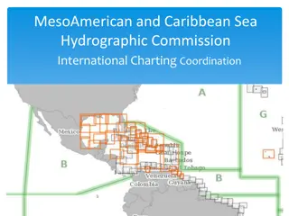
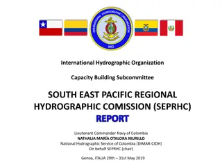
MACHC Activities and Initiatives Report
IRCC-10
M
e
s
o
-
A
m
e
r
i
c
a
n
a
n
d
C
a
r
i
b
b
e
a
n
S
e
a
H
y
d
r
o
g
r
a
p
h
i
c
C
o
m
m
i
s
s
i
o
n
R
e
p
o
r
t
t
o
I
R
C
C
O
r
g
a
n
i
z
a
t
i
o
n
Chair: RADM Enrique Flores Morado (MX)
Vice Chair: Kathryn Ries (US)
Members: Brazil, Colombia, Cuba, France, Guatemala, Jamaica, Mexico,
Netherlands, Suriname, Trinidad and Tobago, United Kingdom, United States of
America, Venezuela.
Associate Members: Antigua and Barbuda, Barbados, Belize, Costa Rica,
Dominican Republic, El Salvador, Grenada, Guyana, Haiti, Honduras, Nicaragua,
Panama, Saint Lucia, Saint Kitts and Nevis, Saint Vincent and the Grenadines.
Industry Participation – EOMAP, Fugro Pelagos, IIC Technologies, Ocean Wise
Ltd., Teledyne CARIS, and ESRI
Organizational Participation – IALA, IC-ENC, IMO, INEGI, THSOA, University of
the West Indies and York University
L
a
s
t
M
e
e
t
i
n
g
C
C
a
a
p
p
a
a
c
c
i
i
t
t
y
y
B
B
u
u
i
i
l
l
d
d
i
i
n
n
g
g
C
C
o
o
m
m
m
m
i
i
t
t
t
t
e
e
e
e
C
C
h
h
a
a
i
i
r
r
:
:
J
J
e
e
f
f
f
f
B
B
r
r
y
y
a
a
n
n
t
t
(
(
U
U
K
K
)
)
A
c
t
i
v
i
t
i
e
s
C
o
m
p
l
e
t
e
d
i
n
2
0
1
7
T
e
c
h
n
i
c
a
l
I
m
p
l
e
m
e
n
t
a
t
i
o
n
V
i
s
i
t
s
w
e
r
e
u
n
d
e
r
t
a
k
e
n
t
o
D
o
m
i
n
i
c
a
n
R
e
p
u
b
l
i
c
(
J
a
n
u
a
r
y
2
0
1
8
)
a
n
d
E
l
S
a
l
v
a
d
o
r
(
D
e
c
e
m
b
e
r
2
0
1
7
)
T
r
a
i
n
i
n
g
C
o
u
r
s
e
s
•
An MSI Training Course was delivered in St Michael, Barbados, in June
2017.
S
e
m
i
n
a
r
s
•
A two-day Hydrographic Awareness Seminar was organized to precede the
main MACHC meeting in Varadero, Cuba in November 2017.
•
Data Management Workshop with SWAtHC in Montevideo, Uruguay,
November 2017.
•
• Digital Photogrammetry with Satellite Images training course with SWAtHC
in Buenos Aires, Argentina, October 2017.
A
c
t
i
v
i
t
i
e
s
p
l
a
n
n
e
d
f
o
r
2
0
1
8
Technical Visit to Guatemala
Seminar on Raising Awareness of
Hydrography
MBES Processing
Tides & Water Levels Workshop for Spanish
Speakers
M
M
a
a
r
r
i
i
n
n
e
e
E
E
c
c
o
o
n
n
o
o
m
m
i
i
c
c
I
I
n
n
f
f
r
r
a
a
s
s
t
t
r
r
u
u
c
c
t
t
u
u
r
r
e
e
P
P
r
r
o
o
g
g
r
r
a
a
m
m
C
C
h
h
a
a
i
i
r
r
:
:
J
J
i
i
m
m
R
R
o
o
g
g
e
e
r
r
s
s
(
(
U
U
S
S
)
)
M
M
a
a
r
r
i
i
n
n
e
e
E
E
c
c
o
o
n
n
o
o
m
m
i
i
c
c
I
I
n
n
f
f
r
r
a
a
s
s
t
t
r
r
u
u
c
c
t
t
u
u
r
r
e
e
P
P
r
r
o
o
g
g
r
r
a
a
m
m
m
m
e
e
(
(
M
M
E
E
I
I
P
P
)
)
W
W
G
G
•
The MACHC password protected ENC Viewer was discontinued. Only the
The MACHC password protected ENC Viewer was discontinued. Only the
open ENC Viewer remains available.
open ENC Viewer remains available.
•
Suriname has contributed their ENC to the ENC Viewer in 2017. Eight
Suriname has contributed their ENC to the ENC Viewer in 2017. Eight
Member States (MS) currently contribute their ENC. The MEIP WG
Member States (MS) currently contribute their ENC. The MEIP WG
continues to encourage MS to contribute ENC to the Viewer in the future.
continues to encourage MS to contribute ENC to the Viewer in the future.
Suriname ENC in the MACHC ENC Viewer
Suriname ENC in the MACHC ENC Viewer
M
M
a
a
r
r
i
i
n
n
e
e
E
E
c
c
o
o
n
n
o
o
m
m
i
i
c
c
I
I
n
n
f
f
r
r
a
a
s
s
t
t
r
r
u
u
c
c
t
t
u
u
r
r
e
e
P
P
r
r
o
o
g
g
r
r
a
a
m
m
m
m
e
e
(
(
M
M
E
E
I
I
P
P
)
)
W
W
G
G
•
SDI / MSDI website research was conducted by the MEIP WG
SDI / MSDI website research was conducted by the MEIP WG
during 2017. Website addresses were noted by the MEIP WG.
during 2017. Website addresses were noted by the MEIP WG.
•
There are many SDI / MSDI websites available within the MACHC
There are many SDI / MSDI websites available within the MACHC
community. Individual countries and GeoSur make data available
community. Individual countries and GeoSur make data available
for other purposes within the MACHC region.
for other purposes within the MACHC region.
•
El Salvador SDI GIS Portal
El Salvador SDI GIS Portal
M
M
A
A
C
C
H
H
C
C
I
I
n
n
t
t
e
e
g
g
r
r
a
a
t
t
e
e
d
d
C
C
h
h
a
a
r
r
t
t
i
i
n
n
g
g
C
C
o
o
m
m
m
m
i
i
t
t
t
t
e
e
e
e
C
C
h
h
a
a
i
i
r
r
:
:
J
J
o
o
h
h
n
n
N
N
y
y
b
b
e
e
r
r
g
g
(
(
U
U
S
S
)
)
V
V
i
i
c
c
e
e
C
C
h
h
a
a
i
i
r
r
:
:
R
R
i
i
c
c
a
a
r
r
d
d
o
o
F
F
r
r
e
e
i
i
r
r
e
e
(
(
B
B
r
r
a
a
z
z
i
i
l
l
)
)
MACHC Integrated Charting Committee (MICC)
842
842
Available
Available
ENC’s
ENC’s
12 Band 1
12 Band 1
34 Band 2
34 Band 2
106 Band 3
106 Band 3
239 Band 4
239 Band 4
406 Band 5
406 Band 5
45 Band 6
45 Band 6
Cruise Ship Port Analysis
Cruise ship analysis identified 43 ports lacking
large scale coverage
–
14 of these 43 ports have ENC coverage planned
Difficulties encountered and challenges yet to
be addressed
Promoting the Spanish language with training
courses and translations.
Low budget allocated to hydrography which
hinders the Hydrographic capacities.
Difficulties encountered and challenges yet to
be addressed
Although most of the member countries are in
phase 3 of the hydrographic capacity
development strategy of the IHO, many of the
countries in the region have an insufficient
hydrographic development.
Achievements/Outputs/Conclusions
Coverage of nautical charts in the region has
not been reached, however it has been
possible to identify areas of cartographic
interest through of cruise ship analysis through
AIS information, there is also a great interest in
the development of a methodology for the
evaluation of hydrographic risk of the region by
the different countries.
Achievements/Outputs/Conclusions
Some countries in the region have contributed
funding to strengthen the hydrographic
capacities in the Region like Mexico with
FOCAHIMECA.
There is also a renewed interest in MSDI with
the involvement of some of the countries of the
region in the working group on marine spatial
information of UN-GGIM.
Actions Required of IRCC 10
Please note this report
T
h
a
n
k
Y
o
u
The International Hydrographic Organization's (IHO) Inter-Regional Coordination Committee (IRCC) Meso-American and Caribbean Sea Hydrographic Commission (MACHC) has been involved in various activities and initiatives. This includes technical visits, training courses, seminars, and workshops aimed at enhancing hydrographic awareness and data management. Plans for 2018 include more technical visits and workshops. The Marine Economic Infrastructure Programme (MEIP) Working Group focuses on ENC contributions and viewer access. The committee comprises members from various countries and industry participants, working towards improved marine infrastructure and collaboration.

Download Presentation

Please find below an Image/Link to download the presentation.
The content on the website is provided AS IS for your information and personal use only. It may not be sold, licensed, or shared on other websites without obtaining consent from the author.If you encounter any issues during the download, it is possible that the publisher has removed the file from their server.
You are allowed to download the files provided on this website for personal or commercial use, subject to the condition that they are used lawfully. All files are the property of their respective owners.
The content on the website is provided AS IS for your information and personal use only. It may not be sold, licensed, or shared on other websites without obtaining consent from the author.
E N D
Presentation Transcript
IHO INTER-REGIONAL COORDINATION COMMITTEE IRCC-10 Meso-American and Caribbean Sea Hydrographic Commission Report to IRCC
Organization Chair: RADM Enrique Flores Morado (MX) Vice Chair: Kathryn Ries (US) Members: Brazil, Colombia, Cuba, France, Guatemala, Jamaica, Mexico, Netherlands, Suriname, Trinidad and Tobago, United Kingdom, United States of America, Venezuela. Associate Members: Antigua and Barbuda, Barbados, Belize, Costa Rica, Dominican Republic, El Salvador, Grenada, Guyana, Haiti, Honduras, Nicaragua, Panama, Saint Lucia, Saint Kitts and Nevis, Saint Vincent and the Grenadines. Industry Participation EOMAP, Fugro Pelagos, IIC Technologies, Ocean Wise Ltd., Teledyne CARIS, and ESRI Organizational Participation IALA, IC-ENC, IMO, INEGI, THSOA, University of the West Indies and York University
Capacity Building Committee Chair: Jeff Bryant (UK)
Activities Completed in 2017 Technical Implementation Visits were undertaken to Dominican Republic (January 2018) and El Salvador (December 2017) Training Courses An MSI Training Course was delivered in St Michael, Barbados, in June 2017. Seminars A two-day Hydrographic Awareness Seminar was organized to precede the main MACHC meeting in Varadero, Cuba in November 2017. Data Management Workshop with SWAtHC in Montevideo, Uruguay, November 2017. Digital Photogrammetry with Satellite Images training course with SWAtHC in Buenos Aires, Argentina, October 2017.
Activities planned for 2018 Technical Visit to Guatemala Seminar on Raising Awareness of Hydrography MBES Processing Tides & Water Levels Workshop for Spanish Speakers
Marine Economic Infrastructure Program Chair: Jim Rogers (US)
Marine Economic Infrastructure Programme (MEIP) WG The MACHC password protected ENC Viewer was discontinued. Only the open ENC Viewer remains available. Suriname has contributed their ENC to the ENC Viewer in 2017. Eight Member States (MS) currently contribute their ENC. The MEIP WG continues to encourage MS to contribute ENC to the Viewer in the future. Suriname ENC in the MACHC ENC Viewer
Marine Economic Infrastructure Programme (MEIP) WG SDI / MSDI website research was conducted by the MEIP WG during 2017. Website addresses were noted by the MEIP WG. There are many SDI / MSDI websites available within the MACHC community. Individual countries and GeoSur make data available for other purposes within the MACHC region. El Salvador SDI GIS Portal
MACHC Integrated Charting Committee Chair: John Nyberg (US) Vice Chair: Ricardo Freire (Brazil)
MACHC Integrated Charting Committee (MICC) 842 Available ENC s 12 Band 1 34 Band 2 106 Band 3 239 Band 4 406 Band 5 45 Band 6
Cruise Ship Port Analysis Cruise ship analysis identified 43 ports lacking large scale coverage 14 of these 43 ports have ENC coverage planned
Difficulties encountered and challenges yet to be addressed Promoting the Spanish language with training courses and translations. Low budget allocated to hydrography which hinders the Hydrographic capacities.
Difficulties encountered and challenges yet to be addressed Although most of the member countries are in phase 3 of the hydrographic capacity development strategy of the IHO, many of the countries in the region have an insufficient hydrographic development.
Achievements/Outputs/Conclusions Coverage of nautical charts in the region has not been reached, however it has been possible to identify areas of cartographic interest through of cruise ship analysis through AIS information, there is also a great interest in the development of a methodology for the evaluation of hydrographic risk of the region by the different countries.
Achievements/Outputs/Conclusions Some countries in the region have contributed funding to strengthen the hydrographic capacities in the Region like Mexico with FOCAHIMECA. There is also a renewed interest in MSDI with the involvement of some of the countries of the region in the working group on marine spatial information of UN-GGIM.


 WG")
 WG")

")