Spatial Planning Development Priorities in Free State: Aligning with National Framework
The National Development Framework (NSDF) guides the Free State's spatial planning focusing on urban networks, resource production regions, ecological infrastructure, and connecting infrastructure. Key areas like Mangaung and Sasolburg are designated for specific development purposes. The plan aims to implement sustainable development pathways, protect agricultural and tourism areas, and align with national strategies for future investment direction.
Download Presentation
Please find below an Image/Link to download the presentation.
The content on the website is provided AS IS for your information and personal use only. It may not be sold, licensed, or shared on other websites without obtaining consent from the author. Download presentation by click this link. If you encounter any issues during the download, it is possible that the publisher has removed the file from their server.
- Spatial Planning
- Free State
- National Development Framework
- Sustainable Development
- Investment Direction

Presentation Transcript
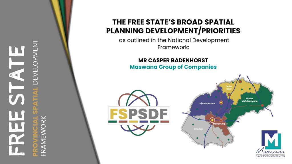
THE FREE STATES BROAD SPATIAL PLANNING DEVELOPMENT/PRIORITIES as outlined in the National Development Framework: PROVINCIAL SPATIAL DEVELOPMENT FREE STATE STATE MR CASPER BADENHORST Maswana Group of Companies FREE FRAMEWORK
The Development Framework (NSDF) provides the spatial expression of the NDP and MSTF strategies, indicating the preferred areas of investment for an array of sectors and industries National Spatial The NSDF will have a prominent impact on the Free State PSDF as the PSDF must directly align with the spatial development drivers and levers reflected in the NSDF. The NSDF clusters spatial strategies into 4 subframe themes. NATIONAL SPATIAL DEVELOPMENT LEVERS 1
NSDF SUB-FRAME 1: NATIONAL URBAN NETWORK NSDF SUB-FRAME 2: NATIONAL RESOURCE PRODUCTION REGIONS 4 Mangaung is classified as a National urban node. The Sasolburg area falls within the Gauteng National Urban Region, which also forms part of the national innovation belt. Kroonstad, Welkom Bethlehem, Harrismith and Phuthaditjhaba have been classified as regional development anchors The northern regions of the Free State form part of the Central Agricultural Heartland as well as the Agri-Enterprise and Small-scale Farming Resource Region. The southern regions of the province form part of the Arid-Agri Innovation Region. The Eastern corner of the province falls within the Eco-Resource Production and livelihood region
NSDF SUB-FRAME 4: NATIONAL ECOLOGICAL INFRASTRUCTURE AND NATURAL RESOURCE BASE NSDF SUB-FRAME 3: NATIONAL CONNECTING AND MOVEMENT INFRASTRUCTURE The N3 Durban Free State Gauteng route is highlighted as a Key National Development Corridor supported by the Maluti a Phofung SEZ. The N1 is as a key national route. Both the N6 and N8 are identified as key regional routes. The Maseru border post and towns near the post have been identified as import and export nodes. The Vaal and Orange form part of the National Water Reticulation and resource infrastructure. The Vaal Central Water management area, as well as the Sasolburg and Parys region fall within the National Ecological and Biodiversity Management Areas. 5
KEY SCOPE : OBJECTIVE OF THE PSDF Implementing a Sustainable Development pathway for the province. To prepare and identify a future spatial distribution of land uses (especially towards protecting areas for agriculture and tourism development). Prepare future development proposals To provide investment direction and confidence in the province. The PSDF needs to be aligned to the NSDF, NDP, FS PGDS, Karoo and Vaal RSDF, and the DALRRD SDF guidelines. To promote a developmental state. To prepare a SPLUMA-compliant PSDF. To guide the space economy of the province To align and give spatial structure Implementation charter A Monitoring and evaluation framework A clear and concise institutional development framework The main objective is to DEVELOP, REFINE, and ADOPT a new CREDIBLE PSDF (as stipulated under Section 15 of the SPLUMA). The existing 2013 and reviewed 2018 PSDF as well as the FS PGDS will be used as a point of departure for this development. Key sub-objectives include: To establish appropriate mechanisms to promote spatial and land use management To align the principles of SPLUMA To address matters of Provincial Interest To align and integrate with the FS PGDS, NSDF To guide the preparation of SDFs for District and Local Municipalities in the Province To present a common spatial agenda for development Promote integrated development among stakeholders To promote Sustainable Development. To provide updated demographic data institutional spatial and 6
Linkages with VAAL SEZ Vaal City Region Petrochemicals Sector Manufacturing Industrial Development Agro-processing Human Settlement Development Tourism Development Maluti a Phofung SEZ Transportation and Logistics Food Processing Agro-processing Settlement Upgrading Agro-Processing Renewable Energy Development Mining and Mineral Beneficiation Industrial Development Cargo and Logistics Development Urban Regeneration ICT Development N8 Corridor Development Linkages with Lesotho Human Settlement Development Industrial Development Public Transportation Commercial Development Infrastructure Development Knowledge Economy 7
THE FSPSDF IS TO TARGET THE IMPROVEMENT OF: Investment Confidence Institutional Capacity (fast- tracking of development applications) Introduce a PRO-DEVELOPMENT and PRO-CONTROL philosophy through the provision of development zones Access to information Transparency in decision-making www.fspsdf.co.za 8