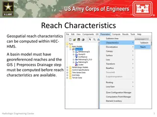
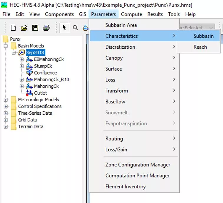
Subbasin Characteristics in HEC-HMS


Subbasin Characteristics
Hydrologic Engineering Center
1
Geospatial subbasin
characteristics can be
computed within HEC-HMS.

Subbasin Characteristics
Hydrologic Engineering Center
2
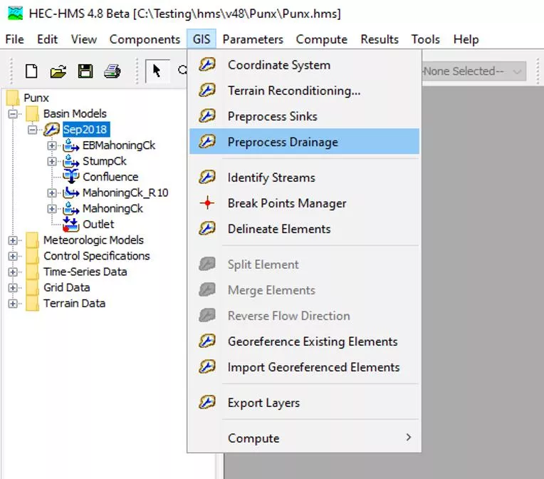
Before subbasin characteristics
are available, the basin model
must have georeferenced
subbasins and the GIS |
Preprocess Drainage steps must
be computed.
Subbasin Characteristics
Hydrologic Engineering Center
3
•
Longest Flowpath Length
•
Longest Flowpath Slope
•
Centroidal Flowpath Length
•
Centroidal Flowpath Slope
•
10-85 Flowpath Length
•
10-85 Slope
•
Basin Slope
•
Basin Relief
•
Relief Ratio
•
Elongation Ratio
•
Drainage Density
Subbasin Characteristics
Hydrologic Engineering Center
4
Longest Flowpath Length and Slope
The longest flowpath extends from the subbasin outlet to the most hydraulically-remote
point upstream. Longest flowpath length is significant in that it is typically used to
determine the time of concentration for a watershed.
The longest flowpath slope is the elevation difference of the most hydraulically-remote
point and the subbasin outlet point divided by the longest flowpath length.
LongestFlowpathSlope = (UpstreamElevation – OutletElevation) / LongestFlowpathLength
Subbasin Characteristics
Hydrologic Engineering Center
5
Centroidal Flowpath Length and Slope
The centroidal flowpath is a subset of
longest flowpath. It begins at the
subbasin outlet and extends upstream
along the longest flowpath until it
reaches the point along the longest
flowpath that is nearest to the
subbasin centroid.
CentroidalFlowpathSlope =
(UpstreamElevation – OutletElevation)
/ CentroidalFlowpathLength
Subbasin Characteristics
Hydrologic Engineering Center
6
10-85 Flowpath Length and Slope
The 10-85 flowpath is also a subset of
longest flowpath. Measuring from the
outlet in the upstream direction, the
10-85 flowpath begins at a point
representing ten percent of the total
length of the longest flowpath and
ends at a point representing eighty-
five percent of the total length.
10_85FlowpathSlope = (85Elevation –
10Elevation) / 10_85FlowpathLength
Subbasin Characteristics
Hydrologic Engineering Center
7
Why do we have different length and
slope calculations?
L
LFP
Plan View: Longest Flowpath
Profile View: Longest Flowpath
500ft
450ft
400ft
Subbasin Characteristics
Hydrologic Engineering Center
8
Basin Slope
The basin slope represents the average slope of the entire subbasin (rise/run). For each
elevation raster value within the subbasin, the algorithm scans the surrounding eight
neighbors and computes the slope using the maximum scanned elevation difference.
The algorithm does not weigh north, east, south, and west neighbors more than diagonal
neighbors; each neighbor is considered equally. The basin slope output is the average of
all the computed slope values in the subbasin.
Subbasin Characteristics
Hydrologic Engineering Center
9
Basin Slope
Basin Slope can be
thought of as the
average slope of all
the Stream Network
arrows.
Subbasin Characteristics
Hydrologic Engineering Center
10
Basin Relief
Basin relief represents the elevation difference between the highest point on the
drainage divide and the outlet point of the subbasin.
Profile View: Longest Flowpath
500ft
450ft
400ft
Subbasin Characteristics
Hydrologic Engineering Center
11
Relief Ratio
The relief ratio is simply the basin relief divided by the length of the longest flowpath.
Profile View: Longest Flowpath
500ft
450ft
400ft
L
LFP
Subbasin Characteristics
Hydrologic Engineering Center
12
Elongation Ratio
The elongation ratio is a dimensionless ratio used to categorize the general shape of a
subbasin. It is a ratio between the diameter of a circle with the same area as the subbasin
and the basin length. Elongation ratio values typically range from 0.2 to 1.0, with lower
values representing elongated basins and values close to 1 representing circular basins.
ElongationRatio = (Area
0.5
/Length)
∗
(2/π
0.5
)
D
C
L
LFP
Elongation Ratio = D
C
/ L
LFP
Subbasin Characteristics
Hydrologic Engineering Center
13
Drainage Density
Drainage density is a metric
used to describe the
efficiency in which a
subbasin is drained by
stream channels. It is
computed by summing the
total length of stream
channels within the subbasin
and then dividing by the
area of the subbasin.
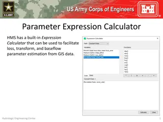
Hey there HMS modelers. My name is Josh Willis and I’m with the Corps of Engineers. This lecture will cover subbasin characteristics computations within HMS. Subbasin characteristics can be accessed by clicking Parameters | Characteristics | Subbasin.
Subbasin characteristics play a crucial role in hydrological modeling within HEC-HMS. Before computing these characteristics, the basin model must have georeferenced subbasins in the GIS. Various parameters such as basin slope, relief, elongation ratio, drainage density, and flowpath lengths and slopes are computed to analyze watershed behavior. Different flowpath segments (longest, centroidal, 10-85) are used to evaluate hydrological processes, each providing valuable insights into watershed dynamics.

Download Presentation

Please find below an Image/Link to download the presentation.
The content on the website is provided AS IS for your information and personal use only. It may not be sold, licensed, or shared on other websites without obtaining consent from the author.If you encounter any issues during the download, it is possible that the publisher has removed the file from their server.
You are allowed to download the files provided on this website for personal or commercial use, subject to the condition that they are used lawfully. All files are the property of their respective owners.
The content on the website is provided AS IS for your information and personal use only. It may not be sold, licensed, or shared on other websites without obtaining consent from the author.
E N D
Presentation Transcript
Subbasin Characteristics Geospatial subbasin characteristics can be computed within HEC-HMS. Hydrologic Engineering Center 1
Subbasin Characteristics Before subbasin characteristics are available, the basin model must have georeferenced subbasins and the GIS | Preprocess Drainage steps must be computed. Hydrologic Engineering Center 2
Subbasin Characteristics Basin Slope Basin Relief Relief Ratio Elongation Ratio Drainage Density Longest Flowpath Length Longest Flowpath Slope Centroidal Flowpath Length Centroidal Flowpath Slope 10-85 Flowpath Length 10-85 Slope Hydrologic Engineering Center 3
Subbasin Characteristics Longest Flowpath Length and Slope The longest flowpath extends from the subbasin outlet to the most hydraulically-remote point upstream. Longest flowpath length is significant in that it is typically used to determine the time of concentration for a watershed. The longest flowpath slope is the elevation difference of the most hydraulically-remote point and the subbasin outlet point divided by the longest flowpath length. LongestFlowpathSlope = (UpstreamElevation OutletElevation) / LongestFlowpathLength Hydrologic Engineering Center 4
Subbasin Characteristics Centroidal Flowpath Length and Slope The centroidal flowpath is a subset of longest flowpath. It begins at the subbasin outlet and extends upstream along the longest flowpath until it reaches the point along the longest flowpath that is nearest to the subbasin centroid. CentroidalFlowpathSlope = (UpstreamElevation OutletElevation) / CentroidalFlowpathLength Hydrologic Engineering Center 5
Subbasin Characteristics 10-85 Flowpath Length and Slope The 10-85 flowpath is also a subset of longest flowpath. Measuring from the outlet in the upstream direction, the 10-85 flowpath begins at a point representing ten percent of the total length of the longest flowpath and ends at a point representing eighty- five percent of the total length. 10_85FlowpathSlope = (85Elevation 10Elevation) / 10_85FlowpathLength Hydrologic Engineering Center 6
Subbasin Characteristics Why do we have different length and slope calculations? 500ft 450ft 400ft Plan View: Longest Flowpath Profile View: Longest Flowpath Hydrologic Engineering Center 7
Subbasin Characteristics Basin Slope The basin slope represents the average slope of the entire subbasin (rise/run). For each elevation raster value within the subbasin, the algorithm scans the surrounding eight neighbors and computes the slope using the maximum scanned elevation difference. The algorithm does not weigh north, east, south, and west neighbors more than diagonal neighbors; each neighbor is considered equally. The basin slope output is the average of all the computed slope values in the subbasin. Hydrologic Engineering Center 8
Subbasin Characteristics Basin Slope Basin Slope can be thought of as the average slope of all the Stream Network arrows. Hydrologic Engineering Center 9
Subbasin Characteristics Basin Relief Basin relief represents the elevation difference between the highest point on the drainage divide and the outlet point of the subbasin. 500ft 450ft 400ft Profile View: Longest Flowpath Hydrologic Engineering Center 10
Subbasin Characteristics Relief Ratio The relief ratio is simply the basin relief divided by the length of the longest flowpath. 500ft 450ft 400ft Profile View: Longest Flowpath Hydrologic Engineering Center 11
Subbasin Characteristics Elongation Ratio The elongation ratio is a dimensionless ratio used to categorize the general shape of a subbasin. It is a ratio between the diameter of a circle with the same area as the subbasin and the basin length. Elongation ratio values typically range from 0.2 to 1.0, with lower values representing elongated basins and values close to 1 representing circular basins. ElongationRatio = (Area0.5/Length) (2/ 0.5) DC Elongation Ratio = DC / LLFP Hydrologic Engineering Center 12
Subbasin Characteristics Drainage Density Drainage density is a metric used to describe the efficiency in which a subbasin is drained by stream channels. It is computed by summing the total length of stream channels within the subbasin and then dividing by the area of the subbasin. Hydrologic Engineering Center 13