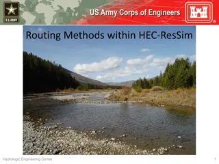
Managing Water Resources Data with HEC-DSSVue
Water Resources Data Management
with HEC
-
DSSVue
Managing HEC-DSS Gridded Data
Objectives—This lecture should teach you
How grids represent spatially distributed data
Sources of gridded data
How DSS stores data in grids
Organization of grid data in DSS records
Naming conventions for grids
What tools are available for loading, viewing,
and manipulating DSS grid data
Topics
Why are there grids in DSS?
NEXRAD radar and the modClark rainfall-runoff method
The SHG grid indexing systems
Storing grids in DSS
Gory Details
Naming Conventions
The Grid Data toolkit
Loading Grids
Displaying grids
Grouping grids into time series
Calculating with grids
Gridded Meteorological Products
1990
Prototype WSR-88D radar
station in Norman Oklahoma
1995
2000
2005
2010
2015
2020
ABRFC – Stage III – NetCDF
HRAP grids in HEC-DSS
HEC ModClark transform
Multiple RFCs – Stage III – XMRG
HEC develops SHG
MPE Supersedes Stage III
QPE & QPF in GRIB
MRMS QPE in GRIB
HEC develops GageInterp
HEC develops HEC-MetVue
HEC develops Grid2DSS
CRREL develops
SNODAS2DSS
RTMA Temperature in GRIB
NOHRSC SNODAS
USACE Growing Use
of Interpolated Grids
Why are there grids in DSS?
Why are there grids in DSS?
Reliable precipitation estimates are crucial to
flood hydrograph analysis
NEXRAD radar offers a potential for
improvement over basin-average precipitation
estimates from rain gages
Use of grid methods for hydrologic modeling
DSS should support data types used for
hydrologic analysis and forecasting
Application of Spatial Data
The inclusion of spatially
distributed modeling
methods in HEC-HMS and
HEC-RAS require spatially
distributed boundary
conditions.
The Standard Hydrologic Grid (SHG)
Based on USGS National Atlas Spatial Reference
System (EPSG:5070)
https://www.spatialreference.org/ref/sr-org/epsg-5070/html/
Albers Equal-Area Projection (handy for calculating
volumes from depths)
More commonly used for natural resource data than
HRAP’s polar stereographic
Supports variable resolution (10, 20, 50
10km)
Has a fixed size and positions of cells
Still limited to 48-state applications
Very little time-varying data natively in SHG
Standard Hydrologic Grid (SHG)
SHG locations identified
by cell indices
For a given cell size, an
index pair always refers
to the same location
Cell row and column
numbers start at the
origin of the coordinate
system, so it’s easy to
convert cell numbers to
northing and easting
Features for Grids in HEC-DSS
Internally, DSS grid records
contain
Full coordinate system
definition
Position of row, column
origin
Interfaces to support SHG-
like Grids based on UTM
coordinates
UTM Discretization in HEC-
HMS
Load UTM grids from various
formats
Interpolate UTM grids with
HEC-HMS and HEC-MetVue
UTM 39S
Madagascar
Gridded Precipitation and Temperature
Data Sources
RFC – River Forecast Center
http://water.weather.gov/ahps/rfc/rfc.php
https://www.hec.usace.army.mil/confluence/hmsdocs/hmsguides/en
semble-analysis-simulations-in-hec-hms/applying-the-ensemble-
compute-to-flood-forecasting
Cumulus - https://cumulus.corps.cloud/
NCEP – National Center for Environmental Predictions
http://nomads.ncep.noaa.gov/
NDFD Precipitation Forecast (QPF)
Example
SNODAS grids
from NOHRSC
SWE
Dept
h
Melt
Cold Content
NOAA National Operational Hydrologic Remote Sensing Center (NOHRSC)
SNOw Data Assimilation System (SNODAS)
Gridded Data Sources
https://www.hec.usace.army.mil/confluence/hmsdocs/hmsguides/working-with-
gridded-boundary-condition-data/gridded-data-sources
Storing Grids in DSS
Time Series Data Organization in DSS
Header
Units
Data type
Time offset (for Regular
Time Series)
Data Array
Values
Values & times (For
Irregular Time Series)
Array
Time Series
Grid Data Organization in DSS
Header
Units
Data type
Time (start & end)
Location
Data Array
Values
Like a regular time
series, but at regular
intervals in space
Array
Equivalent grid, array by
rows from lower left cell
DSS Grid Header Contents (Highlights)
Cell Size (in meters)
Origin cell indices
Number of columns
Number of rows
Coordinate system
Position of origin cell
Start time
End time
Data units
Data type
Data Statistics
Data Compression
method
Identifying a Grid by Pathname Parts
A Part: Grid System
(HRAP, SHG, UTM32S)
B Part: Location
(ABRFC, White River)
C Part: Parameter
(Precip, Temp)
D Part: Start time
(17JAN1996:0300)
E Part: End time
(17JAN1996:0400)
F Part: Version
(StageIII, model)
Reference for C Part pathname for HEC-HMS -
https://www.hec.usace.army.mil/confluence/hmsdocs
/hmsum/4.11/shared-component-data/grid-data
Precipitation Grids in DSS
Parameter (C part): PRECIPITATION
Units: mm
Data Type: PER-CUM (Period Cumulative)
Time Reference: UTC (Not local time)
Examples
Daily precipitation and temperature products from
PRISM
Hourly MRMS
Forecast results
NBM
NAM
Grid Tools for DSS
Grid Tools in DSS
CWMS/HEC-RTS CAVI displays grids in sequence
HEC-MetVue for Grid Display/Editing/Analysis, and
Automated Processing.
HEC-HMS for importing, processing, and creating
HEC-DSSVue displays grids and metadata
Methods available for scripting in DSSVue
Extract sub-regions
Mosaic grids together
Simple math
DSS Grids in HEC Software
A gridset is a sequence of grids
Specified by
Source – file name or wildcard
Pathname parts (A, B, C, F)
Time step (difference between D & E parts)
Allows many grid records to be managed as a
single entity
Gridset Editor from CAVI
Grid Display in CAVI
CAVI Time Window and Animation
Controls
User-selected time window
Sequence play (pseudo-animation)
VCR-like controls
Grid Display in MetVue
DSS Grid Selector in HEC-MetVue
DSS Grid Selector in HEC-HMS
HEC-HMS Gridded Data Importer
Purpose
Streamline the process of converting various gridded dataset
formats to HEC-DSS format for use within HEC-HMS.
Supported Dataset Formats
netCDF, HDF, GRIB, ASC, TIF, BIL, SNODAS, DSS
Additional Features
Project gridded data to SHG or UTM projections
Clip to watershed boundary
Set correct data units and type
Examples provided -
https://www.hec.usace.army.mil/confluence/hmsdocs
/hmsguides/working-with-gridded-boundary-
condition-data
HEC-HMS Gridded Data Importer
HEC-HMS Gridded Data Importer
•
Clip data to project
extent
•
Set projection
•
Set target cell size
•
Specify resampling
method
HEC-HMS Gridded Data Importer
•
Specify destination file and file path
HEC-HMS Gridded Data Tools
Manipulate gridsets
o
Calculator (scale or convert data units)
o
Clipper (clip to watershed to reduce file
size)
o
Grid to Point (compute subbasin time-
series)
o
Normalizer (adjust one gridset to totals
from another)
o
Sanitizer (remove unwanted data
values)
o
Shifter (shift in time)
HEC-HMS Grid Interpolation
Interpolation option creates gridded datasets using
gage data and discretization defined in the basin
model
Interpolation methods:
o
Inverse distance
o
Inverse distance squared
o
Nearest neighbor
o
Bilinear
Adjustment options:
o
Bias
o
Lapse rate
Basin Averaging from Grids in MetVue
Cataloging Grid Records in DssVue
Grid Display in HEC-DssVue
GridInfo (basic metadata)
Detailed GridInfo (complete metadata)
Any Questions or Discussion?
Water Resources Data Management with HEC-DSSVue
L-11/152-13/Steissberg
L-4.1
Learn about managing gridded data in HEC-DSSVue, including how grids represent spatial data, storing data in DSS, naming conventions, tools for manipulation, and more. Explore the importance of grids in hydrologic modeling and the application of spatial data in HEC-HMS and HEC-RAS.

Download Presentation

Please find below an Image/Link to download the presentation.
The content on the website is provided AS IS for your information and personal use only. It may not be sold, licensed, or shared on other websites without obtaining consent from the author.If you encounter any issues during the download, it is possible that the publisher has removed the file from their server.
You are allowed to download the files provided on this website for personal or commercial use, subject to the condition that they are used lawfully. All files are the property of their respective owners.
The content on the website is provided AS IS for your information and personal use only. It may not be sold, licensed, or shared on other websites without obtaining consent from the author.
E N D
Presentation Transcript
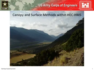
Water Resources Data Management with HEC-DSSVue Managing HEC-DSS Gridded Data
ObjectivesThis lecture should teach you How grids represent spatially distributed data Sources of gridded data How DSS stores data in grids Organization of grid data in DSS records Naming conventions for grids What tools are available for loading, viewing, and manipulating DSS grid data
Topics Why are there grids in DSS? NEXRAD radar and the modClark rainfall-runoff method The SHG grid indexing systems Storing grids in DSS Gory Details Naming Conventions The Grid Data toolkit Loading Grids Displaying grids Grouping grids into time series Calculating with grids
Gridded Meteorological Products 1990 2015 2020 1995 2005 2010 2000
Why are there grids in DSS? Reliable precipitation estimates are crucial to flood hydrograph analysis NEXRAD radar offers a potential for improvement over basin-average precipitation estimates from rain gages Use of grid methods for hydrologic modeling DSS should support data types used for hydrologic analysis and forecasting
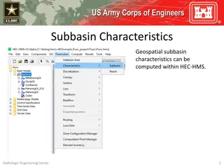
Application of Spatial Data The inclusion of spatially distributed modeling methods in HEC-HMS and HEC-RAS require spatially distributed boundary conditions.
The Standard Hydrologic Grid (SHG) Based on USGS National Atlas Spatial Reference System (EPSG:5070) https://www.spatialreference.org/ref/sr-org/epsg-5070/html/ Albers Equal-Area Projection (handy for calculating volumes from depths) More commonly used for natural resource data than HRAP s polar stereographic Supports variable resolution (10, 20, 50 10km) Has a fixed size and positions of cells Still limited to 48-state applications Very little time-varying data natively in SHG
Standard Hydrologic Grid (SHG) SHG locations identified by cell indices For a given cell size, an index pair always refers to the same location Cell row and column numbers start at the origin of the coordinate system, so it s easy to convert cell numbers to northing and easting
Features for Grids in HEC-DSS Internally, DSS grid records contain Full coordinate system definition Position of row, column origin Interfaces to support SHG- like Grids based on UTM coordinates UTM Discretization in HEC- HMS Load UTM grids from various formats Interpolate UTM grids with HEC-HMS and HEC-MetVue UTM 39S Madagascar
Gridded Precipitation and Temperature Data Sources RFC River Forecast Center http://water.weather.gov/ahps/rfc/rfc.php https://www.hec.usace.army.mil/confluence/hmsdocs/hmsguides/en semble-analysis-simulations-in-hec-hms/applying-the-ensemble- compute-to-flood-forecasting Cumulus - https://cumulus.corps.cloud/ NCEP National Center for Environmental Predictions http://nomads.ncep.noaa.gov/
Example SNODAS grids from NOHRSC NOAA National Operational Hydrologic Remote Sensing Center (NOHRSC) SNOw Data Assimilation System (SNODAS) SWE Dept h Melt Cold Content
Gridded Data Sources https://www.hec.usace.army.mil/confluence/hmsdocs/hmsguides/working-with- gridded-boundary-condition-data/gridded-data-sources
Time Series Data Organization in DSS Header Units Data type Time offset (for Regular Time Series) Data Array Values Values & times (For Irregular Time Series) Array 90 3 3 3 40 120 140 190 Time Series
Grid Data Organization in DSS Header Units Data type Time (start & end) Location Data Array Values Like a regular time series, but at regular intervals in space Array 1 2 3 4 5 6 7 8 9 Equivalent grid, array by rows from lower left cell 7 8 9 4 5 6 1 2 3
DSS Grid Header Contents (Highlights) Cell Size (in meters) Origin cell indices Number of columns Number of rows Coordinate system Position of origin cell Start time End time Data units Data type Data Statistics Data Compression method
Identifying a Grid by Pathname Parts A Part: Grid System (HRAP, SHG, UTM32S) B Part: Location C Part: Parameter (Precip, Temp) D Part: Start time E Part: End time F Part: Version (ABRFC, White River) (17JAN1996:0300) (17JAN1996:0400) (StageIII, model) Reference for C Part pathname for HEC-HMS - https://www.hec.usace.army.mil/confluence/hmsdocs /hmsum/4.11/shared-component-data/grid-data
Precipitation Grids in DSS Parameter (C part): PRECIPITATION Units: mm Data Type: PER-CUM (Period Cumulative) Time Reference: UTC (Not local time)
Examples Daily precipitation and temperature products from PRISM Hourly MRMS Forecast results NBM NAM
Grid Tools in DSS CWMS/HEC-RTS CAVI displays grids in sequence HEC-MetVue for Grid Display/Editing/Analysis, and Automated Processing. HEC-HMS for importing, processing, and creating HEC-DSSVue displays grids and metadata Methods available for scripting in DSSVue Extract sub-regions Mosaic grids together Simple math
DSS Grids in HEC Software A gridset is a sequence of grids Specified by Source file name or wildcard Pathname parts (A, B, C, F) Time step (difference between D & E parts) Allows many grid records to be managed as a single entity
CAVI Time Window and Animation Controls User-selected time window Sequence play (pseudo-animation) VCR-like controls
HEC-HMS Gridded Data Importer Purpose Streamline the process of converting various gridded dataset formats to HEC-DSS format for use within HEC-HMS. Supported Dataset Formats netCDF, HDF, GRIB, ASC, TIF, BIL, SNODAS, DSS Additional Features Project gridded data to SHG or UTM projections Clip to watershed boundary Set correct data units and type Examples provided - https://www.hec.usace.army.mil/confluence/hmsdocs /hmsguides/working-with-gridded-boundary- condition-data
HEC-HMS Gridded Data Importer Clip data to project extent Set projection Set target cell size Specify resampling method
HEC-HMS Gridded Data Importer Specify destination file and file path
HEC-HMS Gridded Data Tools Manipulate gridsets o Calculator (scale or convert data units) o Clipper (clip to watershed to reduce file size) o Grid to Point (compute subbasin time- series) o Normalizer (adjust one gridset to totals from another) o Sanitizer (remove unwanted data values) o Shifter (shift in time)
HEC-HMS Grid Interpolation Interpolation option creates gridded datasets using gage data and discretization defined in the basin model Interpolation methods: o Inverse distance o Inverse distance squared o Nearest neighbor o Bilinear Adjustment options: o Bias o Lapse rate


")
")


")


")


")
")