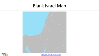
Blank Israel Map
Explore a detailed map of Israel and Palestine, highlighting countries, territories, capitals, and major cities. The map includes Lebanon, Syria, Egypt, Jordan, Iraq, Saudi Arabia, Mediterranean Sea, Red Sea, and more.
0 views • 4 slides

Understanding Vernier Scales and Precision Measurement Devices
Vernier scales, named after French cartographer Pierre Vernier, enhance precision in measuring even the smallest scale divisions. Instruments like the theodolite, slide calipers, and Fortin's barometer utilize vernier scales for accurate readings. Learn about key terms like least count and vernier c
5 views • 11 slides
WMO Scale of Assessment of Members' Contributions for 2024-2027 Period
The WMO scale of assessment for members' contributions is based on the latest United Nations scales approved by the General Assembly. The scales for the 2024-2027 period will be determined considering the UN scales from the 2021 and 2024 sessions. Adjustments for membership differences will be made,
4 views • 6 slides

Understanding Measurement Scales and Scaling Techniques
Measurement scales play a crucial role in marketing research, with techniques like scaling helping to categorize data. The content discusses four types of measurement scales: nominal, ordinal, interval, and ratio, outlining their characteristics and differences. Scaling techniques involve placing re
5 views • 7 slides

Exploring Melodic Ideas with Pentatonic Scales in Music Composition
Delve into the world of music composition by understanding and utilizing pentatonic scales to develop captivating melodies. Learn key terminology, explore the C pentatonic scale, and discover how major and minor pentatonic scales can influence the mood of your compositions. Dive deep into the power
1 views • 18 slides
Mastering Map Grid References for Accurate Location Identification
Learn how to find places on a map using grid references. Discover how to identify map symbols and determine accurate six-figure grid references. Follow step-by-step guidance to pinpoint locations with precision on maps. Enhance your mapping skills and boost your navigational expertise efficiently.
0 views • 18 slides
Understanding Grid References on Maps
Learn how to find places on a map using grid references, the importance of knowing exact locations on a map, and practice identifying 4-figure grid references independently. Discover how grids on maps help in quickly locating places and memorize the process with the mnemonic "Along the corridor and
0 views • 9 slides
Understanding Regional Map Projections and Plotting Using WRF-ARW
Explore different map projections such as Lambert, Polar, Mercator, and Lat-lon in the context of WRF-ARW model. Learn about specifying grid spacing, map factors, and pole location adjustments. Discover how to create plots using Python with wrf-python for regional domains.
0 views • 13 slides
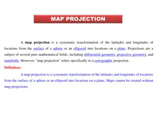
Understanding Map Projections: Types and Applications
Map projection is a systematic transformation of latitudes and longitudes from a curved surface to a flat plane. There are various classifications based on construction methods, tangent surface position, view point of light, and qualities like equal area and equi-distance. Zenithal Polar Equidistanc
0 views • 9 slides

Military Academy Map and Navigation Presentation
This presentation introduces basic map reading and navigation skills essential for Military Academy students. It covers various types of maps, map symbols, measuring distance, and understanding topographical features like physical and man-made elements. Navigation is highlighted as a critical skill
0 views • 18 slides
Advanced Navigation and Route Planning for Duke of Edinburgh Award Expedition Training Course
Learn advanced map and compass skills essential for Duke of Edinburgh Silver Award expeditions. Discover how to read topographical maps, navigate using contours, understand map scale, and interpret map symbols to enhance your outdoor experience.
0 views • 15 slides

Comprehensive Overview of the Intelligence and Development Scales - Second Edition (IDS-2)
The Intelligence and Development Scales - Second Edition (IDS-2), developed by Dr. Jane Yeomans, is a comprehensive assessment tool for individuals aged 5 to 21. It includes cognitive and general development domains, with subtests covering intelligence scales, executive functions, psychomotor skills
0 views • 25 slides
Understanding Scales in Maps and Plans
Explore the concept of scales in maps and plans, including number scales and bar scales. Learn how to work with different scales, calculate actual distances, and understand the advantages and disadvantages of each scale type. Engage in activities to reinforce your understanding of scales in a practi
0 views • 32 slides

WaferMap Configuration Guide for Graph Builder
This guide provides detailed instructions on setting up WaferMap in Graph Builder, preparing map files, distributing and installing map files, creating wafer maps by cube/sub-chunk/chunk, using map shapes as background, and accessing a custom map creator tool.
0 views • 6 slides
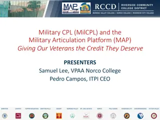
Empowering Veterans Through the MAP Initiative
The Military Articulation Platform (MAP) aims to give veterans the credit they deserve by articulating college courses with ACE credit recommendations. This initiative allows veterans to receive up to one year of credit, enabling them to achieve their educational goals and access high-wage jobs. Thr
5 views • 35 slides
Essential Guide to Map Reading and Navigation Techniques
Discover the fundamentals of map reading and navigation developed by Dave Bere. Explore various types of maps used within SES, learn how to use different maps effectively, and understand the importance of map care and folding. From understanding marginal information to mastering compasses and bearin
0 views • 53 slides

Salary Study Recommendations Summary
The salary study conducted on February 24, 2015 highlighted certain flaws in the current state of the professional, administrative, classified, and facilities scales. The options presented include creating new scales with a uniform distribution or adjusting existing scales to eliminate frozen steps.
0 views • 13 slides
Engineering Scale and Different Types of Scales
Engineering scale plays a crucial role in reducing or enlarging dimensions of large or tiny objects to fit standard size drawing sheets. This article covers the concept of reducing scale, representative factor, types of scales like plain, diagonal, vernier, and more, along with detailed construction
0 views • 11 slides
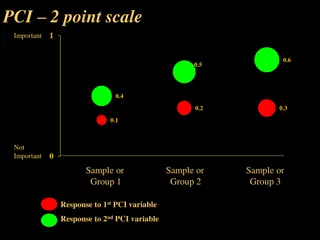
Comprehensive Overview of Point Comparison Importance (PCI) Scales
Explore a detailed examination of various Point Comparison Importance (PCI) scales ranging from 2 to 9 points, each assessing the importance level of different variables. These scales provide insights into respondents' perceptions, with descriptions and sample groups for each scale illustrated in th
0 views • 8 slides
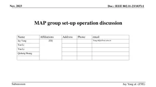
Proposal for Dynamic Multi-AP Coordination in IEEE 802.11-23
This proposal focuses on enhancing the reliability of multi-AP coordination in IEEE 802.11-23 through the formation and management of MAP (Multi-AP) groups. It discusses the limitations of the current setup and suggests a dynamic approach where multiple APs can form MAP groups flexibly. The document
0 views • 11 slides
Understanding Basic Map Skills and Terms
Explore the essential map skills and terms such as map key/legend, compass rose, scale, latitude, longitude, Equator, Prime Meridian, hemispheres, and more to enhance your map reading and interpretation skills effectively.
0 views • 7 slides
Understanding Map Concepts: An Overview
Exploring essential map-related terms and concepts such as map projection, hemisphere, latitude, longitude, scale, equator, prime meridian, map symbol, and globe. Enhance your understanding of how maps represent Earth's surface and the key elements involved in cartography.
0 views • 14 slides
Exploring Likert Scale and Survey Examples for Effective Data Collection
Dive into the world of Likert scale with examples for surveys covering agreement, relevance, frequency, importance, quality, likelihood, dichotomous scales, three-point scales, four-point scales, five-point scales, and seven-point scales. Understand the nuances of expressing opinions, preferences, a
0 views • 5 slides
Understanding Temperature Measurement with Thermometers
Explore the principles of temperature measurement through thermometers, understanding phase changes, behavior of gases, and creating temperature scales. Compare weather forecasts between Moscow and Washington, discussing which city will be warmer and predicting precipitation types. Dive into discuss
0 views • 14 slides
Understanding Temperature Scales and the Ideal Gas Law
This comprehensive guide delves into temperature scales, thermal expansion, and the ideal gas law. Explore the origins of Fahrenheit, Celsius, and Kelvin scales, and learn how to convert between them. Discover the concept of heat, thermal equilibrium, and the Zeroth Law of Thermodynamics. Gain insig
0 views • 14 slides
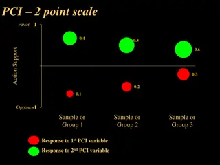
Comprehensive Overview of Point Contrast Interview Scales
Explore a detailed comparison of various Point Contrast Interview scales ranging from 2-point to 9-point scales. Each scale reflects different levels of favor, action support, uncertainty, and opposition, along with sample responses. The scales provide a structured framework for assessing opinions a
0 views • 8 slides

The Important Role of Equivalence Scales in Poverty Dynamics
Equivalence scales play a crucial role in measuring household welfare and poverty dynamics in Russia. This study explores the impact of adjusting scales on poverty lines, chronic poverty, and income mobility using subjective well-being data. The findings reveal higher elasticity for adding adults to
0 views • 26 slides
Understanding Location and Direction on Maps
Location and Direction are essential aspects of reading maps. Traditional methods use relative location descriptions, while modern approaches incorporate absolute coordinates. Maps utilize coordinate systems like Geographic Coordinate System (GCS) and Universal Transverse Mercator System (UTM) to pi
0 views • 30 slides

Development and Evaluation of Harm Reduction Acceptance Scales
Development of scales to measure the acceptance of harm reduction is crucial for understanding public attitudes towards harm reduction strategies. This project focuses on creating valid and reliable scales through a systematic process involving item development, data collection, analysis, and refine
0 views • 15 slides
Messy Situational Map Template with Suggestions for Use
This SA template provides a messy situational map template along with suggestions for use. The initial map should be done by hand on a large piece of paper to allow for quick adjustments and capturing thoughts. The template includes an abstract map and a customizable version for creating more readab
0 views • 4 slides
Various Strategy Maps and Their Components
This content discusses different types of strategy maps including the Balanced Scorecard, Classic Kaplan/Norton Strategy Map, Generic Example Strategy Map, and Basic Strategy Map Background. Each map highlights different perspectives such as financial, customer, internal, and learning & growth, alon
0 views • 22 slides
Understanding Accounting Research Methods: Measurement and Sampling
Measurement is a crucial aspect of research in accounting. It involves assigning numbers to empirical events, objects, or properties. Measurement consists of selecting measurable phenomena, developing mapping rules, and applying these rules appropriately. The process of measurement includes determin
0 views • 63 slides

Understanding Geography: Maps, Globes, and Map Scales
Explore the world of geography through maps and globes in this informative lesson. Discover the advantages and disadvantages of using globes and maps, learn about different types of maps, and understand the importance of measuring distance and map scales. Dive into the realm of conventional signs an
0 views • 13 slides
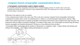
The Evolution of Cartographic Communication Theory in the Digital Age
Cartographic communication theory in digital mapping involves two models: the static map communication model and the interactive map communication model. The static map model follows traditional map-making methods adapted to digital tools, while the interactive map model leverages user feedback to r
0 views • 8 slides

Understanding Sets, Maps, and Map Methods
Explore the concepts of sets, maps, and map methods in programming, focusing on efficient operations like adding, removing, and searching for values. Sets allow unique values with no duplicates, while maps hold key-value pairs like a dictionary. Map methods provide functions for manipulating mapping
0 views • 5 slides
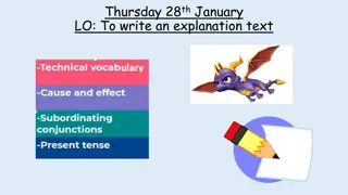
Explaining How Dragons Glide Through the Skies
Dragons use their wings and scales to glide effortlessly through the sky in search of their next meal. By tilting their wings and adjusting their scales, dragons are able to steer and glide smoothly without flapping their wings constantly. This text focuses on the mechanics of dragon flight, highlig
0 views • 5 slides

Introduction to Spark in The Hadoop Stack
Introduction to Spark, a high-performance in-memory data analysis system layered on top of Hadoop to overcome the limitations of the Map-Reduce paradigm. It discusses the importance of Spark in addressing the expressive limitations of Hadoop's Map-Reduce, enabling algorithms that are not easily expr
0 views • 16 slides
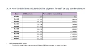
Pay Band Adjustments and Scales Update
Changes in pay band structures and scales have been implemented to benefit staff members at the top of their pay bands, those ineligible for pay progression, new starters, and recently promoted employees. Details include adjustments for staff on pay band maximums, removal of minimum points in pay ba
0 views • 4 slides
Understanding Scales and Representative Fractions in Technical Drawings
Scales play a crucial role in technical drawings by representing the ratio of the linear dimensions of an object to its actual dimensions. This text explains the concept of scales, including enlargement and reduction scales, representative fractions (RF), recommended scales by BIS (SP.46: 2003), and
0 views • 29 slides
Understanding Scoring Scales: Meaning, Calculation, and Advantages
Scoring scales are used to assign numerical values to observations for quantifying attributes or behaviors in various fields. They provide a systematic way to evaluate or measure variables, convert qualitative data into quantitative data, and facilitate analysis and interpretation. This article disc
0 views • 22 slides