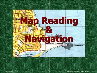
Military Academy Map and Navigation Presentation

This presentation introduces basic map reading and navigation skills essential for Military Academy students. It covers various types of maps, map symbols, measuring distance, and understanding topographical features like physical and man-made elements. Navigation is highlighted as a critical skill for operational effectiveness in the military and other uniformed services.

Download Presentation

Please find below an Image/Link to download the presentation.
The content on the website is provided AS IS for your information and personal use only. It may not be sold, licensed, or shared on other websites without obtaining consent from the author.If you encounter any issues during the download, it is possible that the publisher has removed the file from their server.
You are allowed to download the files provided on this website for personal or commercial use, subject to the condition that they are used lawfully. All files are the property of their respective owners.
The content on the website is provided AS IS for your information and personal use only. It may not be sold, licensed, or shared on other websites without obtaining consent from the author.
E N D
Presentation Transcript
MILITARY ACADEMY Basic Map and Navigation Basic Map and Navigation For more information please contact: lisa.grieves@northumberland.ac.uk lisa.grieves@northumberland.ac.uk
Unit Learning Outcomes Unit Learning Outcomes 1. Understand the volunteering role. 1. Understand the volunteering role. AIM OF PRESENTATION AIM OF PRESENTATION This presentation is designed to give you an awareness of the This presentation is designed to give you an awareness of the various maps used within the Military Academy and to introduce various maps used within the Military Academy and to introduce you to basic map reading and navigation skills. you to basic map reading and navigation skills.
NEED NEED Navigation is a key skill both in the military and other Navigation is a key skill both in the military and other uniformed services and is critical to operational uniformed services and is critical to operational effectiveness. As a student on the Uniformed Services course effectiveness. As a student on the Uniformed Services course you will learn how to read a map and carry out basic you will learn how to read a map and carry out basic navigation. navigation.
LEARNING OBJECTIVES LEARNING OBJECTIVES Purpose and types of maps Purpose and types of maps 4 and 6 figure Grid References 4 and 6 figure Grid References Identifying map symbols Identifying map symbols Measuring distance Measuring distance
MILITARY ACADEMY MAPS MILITARY ACADEMY MAPS Topographical Maps Topographical Maps Ordnance Survey and Training Area mapping Ordnance Survey and Training Area mapping Operational Maps Operational Maps
TOPOGRAPHICAL MAPS TOPOGRAPHICAL MAPS Physical features Physical features Woods, Rivers Man made features Man made features Towns, Roads Relief information Relief information Contours, Triangulation Pillars Contours, Triangulation Pillars Woods, Rivers Towns, Roads
WHAT IS A MAP ? WHAT IS A MAP ? The British Army define maps as: The British Army define maps as: A simplified vertical view of the ground reduced in size onto an A simplified vertical view of the ground reduced in size onto an easily handled piece of paper, showing the outlines of features easily handled piece of paper, showing the outlines of features as they appear from above. They show additional information as they appear from above. They show additional information and use conventional signs to aid the user . and use conventional signs to aid the user .
OTHER MAPS OTHER MAPS Ordnance Survey Map Ordnance Survey Map - - 1:50,000 Training Area Mapping Training Area Mapping 1:25,000 Operational Maps Operational Maps various types 1:50,000 1:25,000 various types
4 FIGURE GRID REFERENCES 4 FIGURE GRID REFERENCES
4 FIGURE GRID REFERENCES 4 FIGURE GRID REFERENCES Let s work out the Let s work out the Grid Reference reading reading along along the corridor then Grid Reference of the the corridor then up of the Red up the stairs the stairs! Red Spot by Spot by
6 FIGURE GRID REFERENCES 6 FIGURE GRID REFERENCES
RED SPOT - - - - - -
IDENTIFYING MAP SYMBOLS IDENTIFYING MAP SYMBOLS
Can you identify the Can you identify the symbols? symbols? 29: _______________ 30: _______________
MEASURING DISTANCE MEASURING DISTANCE
Unit 8 of the Diploma is designed to give students a basic Unit 8 of the Diploma is designed to give students a basic understanding of map reading and navigation. Now that you have understanding of map reading and navigation. Now that you have watched this presentation why not try and answer the questions set watched this presentation why not try and answer the questions set out in the small word booklet on this web page. out in the small word booklet on this web page. Good luck! Good luck! For more information about The Military Academy please contact: For more information about The Military Academy please contact: lisa.grieves@northumberland.ac.uk or visit: or visit: https://www.northumberland.ac.uk/courses/school- leaver/vocational-courses/military-academy/