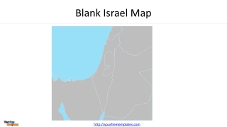
Blank Israel Map
Explore a detailed map of Israel and Palestine, highlighting countries, territories, capitals, and major cities. The map includes Lebanon, Syria, Egypt, Jordan, Iraq, Saudi Arabia, Mediterranean Sea, Red Sea, and more.
1 views • 4 slides

Designing a Vision Board for Personal and Academic Success
Explore creating a vision board to visualize and achieve your personal and academic goals. Reflect on your aspirations, find inspiration, and bring your vision to life through images and words. Learn how to design a vision board, map out your goals, and regularly revisit it to stay motivated and foc
0 views • 11 slides
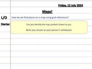
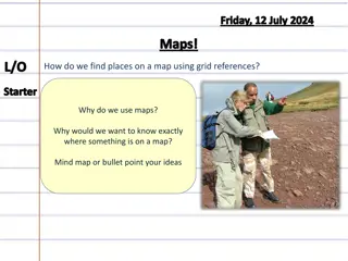
Mastering Map Grid References for Accurate Location Identification
Learn how to find places on a map using grid references. Discover how to identify map symbols and determine accurate six-figure grid references. Follow step-by-step guidance to pinpoint locations with precision on maps. Enhance your mapping skills and boost your navigational expertise efficiently.
2 views • 18 slides
Grid References on Maps
Learn how to find places on a map using grid references, the importance of knowing exact locations on a map, and practice identifying 4-figure grid references independently. Discover how grids on maps help in quickly locating places and memorize the process with the mnemonic "Along the corridor and
0 views • 9 slides
Regional Map Projections and Plotting Using WRF-ARW
Explore different map projections such as Lambert, Polar, Mercator, and Lat-lon in the context of WRF-ARW model. Learn about specifying grid spacing, map factors, and pole location adjustments. Discover how to create plots using Python with wrf-python for regional domains.
0 views • 13 slides
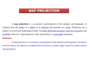
Map Projections: Types and Applications
Map projection is a systematic transformation of latitudes and longitudes from a curved surface to a flat plane. There are various classifications based on construction methods, tangent surface position, view point of light, and qualities like equal area and equi-distance. Zenithal Polar Equidistanc
0 views • 9 slides

Military Academy Map and Navigation Presentation
This presentation introduces basic map reading and navigation skills essential for Military Academy students. It covers various types of maps, map symbols, measuring distance, and understanding topographical features like physical and man-made elements. Navigation is highlighted as a critical skill
0 views • 18 slides
Advanced Navigation and Route Planning for Duke of Edinburgh Award Expedition Training Course
Learn advanced map and compass skills essential for Duke of Edinburgh Silver Award expeditions. Discover how to read topographical maps, navigate using contours, understand map scale, and interpret map symbols to enhance your outdoor experience.
0 views • 15 slides
Psychometric Tests Overview: MAP, SPM, Observation Test
Explore three different psychometric tests - Multi-Dimensional Assessment of Personality (MAP), Standard Progressive Matrices (SPM), and Observation Test. MAP assesses personality dimensions, SPM measures intelligence through abstract reasoning, and the Observation Test evaluates your power of obser
4 views • 14 slides
Guidelines for Design of Cement Concrete Pavement and Interlocking Paver Blocks
This document provides guidelines for designing cement concrete pavements and interlocking paver blocks, covering factors governing design, wheel loads, design period, subgrade characteristics, approximate k values based on CBR values, and the importance of a sub-base below concrete pavements. It em
0 views • 67 slides
WaferMap Configuration Guide for Graph Builder
This guide provides detailed instructions on setting up WaferMap in Graph Builder, preparing map files, distributing and installing map files, creating wafer maps by cube/sub-chunk/chunk, using map shapes as background, and accessing a custom map creator tool.
0 views • 6 slides

Software Engineering Design Principles and Concepts
The chapter discusses the essential principles and concepts in software design, highlighting the four key design models - data design, architectural design, interface design, and component-level design. It emphasizes the importance of traceability to the analysis model, minimizing the gap between so
2 views • 36 slides
Empowering Veterans Through the MAP Initiative
The Military Articulation Platform (MAP) aims to give veterans the credit they deserve by articulating college courses with ACE credit recommendations. This initiative allows veterans to receive up to one year of credit, enabling them to achieve their educational goals and access high-wage jobs. Thr
5 views • 35 slides
Essential Guide to Map Reading and Navigation Techniques
Discover the fundamentals of map reading and navigation developed by Dave Bere. Explore various types of maps used within SES, learn how to use different maps effectively, and understand the importance of map care and folding. From understanding marginal information to mastering compasses and bearin
0 views • 53 slides
Exploration of Human Heat Map Designed by JMP Custom Map Creator
Delve into the intricate human heat map designed by Trent Walker BS and Benjamin Kaffenberger MD from The Ohio State University College of Food, Agricultural, and Environmental Sciences. Uncover the detailed visual representation highlighting key areas of interest.
0 views • 21 slides
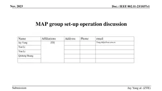
Proposal for Dynamic Multi-AP Coordination in IEEE 802.11-23
This proposal focuses on enhancing the reliability of multi-AP coordination in IEEE 802.11-23 through the formation and management of MAP (Multi-AP) groups. It discusses the limitations of the current setup and suggests a dynamic approach where multiple APs can form MAP groups flexibly. The document
0 views • 11 slides

Introduction to Pig Latin for Data Processing in Hadoop Stack
Pig Latin is a dataflow language and execution system that simplifies composing workflows of multiple Map-Reduce jobs. This system allows chaining together multiple Map-Reduce runs with compact statements akin to SQL, optimizing the order of operations for efficiency. Alongside Pig Latin, the Hadoop
0 views • 20 slides

Design Inspiration and Elements in Costume and Fashion Design
Dive into the world of costume and fashion design through a visual journey of finding design inspiration, understanding the design process, emphasizing originality, and exploring different sources of creativity. Discover how technology, art, food, history, architecture, and nature can spark innovati
0 views • 45 slides
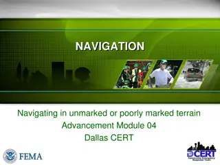
Navigating Techniques without a Map: CERT Training Guide
Gain essential navigation skills for unmarked or poorly marked terrains through this module. Learn methods for navigating without a map, using a map effectively, and preparing mentally for getting lost. Discover the importance of carrying a compass, knife, and matches for CERT team members. Master t
0 views • 37 slides
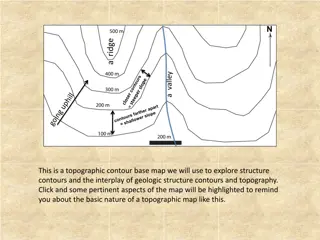
Topographic Contour Maps for Geologic Exploration
A topographic contour base map is a valuable tool for exploring geologic structures and their interplay with topography. By analyzing strike angles, parallel lines, and structure contours, one can determine the orientation, strike, and dip of geologic features. This information can be used to map ou
0 views • 4 slides

High-Tech Survey Methods for Continuous Cadastral Map Generation
Generation of cadastral maps through advanced survey techniques using ortho-images, DGPS/GNSS, and ETS. The process involves obtaining boundary vectors from ortho-images, surveying obscured areas with DGPS/GNSS and ETS, and integrating datasets in a GIS environment. The objective is to create contin
0 views • 14 slides

Enhancing Piping Design Efficiency with Spec-Driven Technology
Explore how Spec-Driven Piping technology powered by CADACTIVE offers a standardized approach for piping design in Creo Parametric. This innovative extension streamlines design communication, eliminates errors, and improves design efficiency by utilizing a master catalog, automated checking capabili
0 views • 15 slides
Basic Map Skills and Terms
Explore the essential map skills and terms such as map key/legend, compass rose, scale, latitude, longitude, Equator, Prime Meridian, hemispheres, and more to enhance your map reading and interpretation skills effectively.
0 views • 7 slides

Map Concepts: An Overview
Exploring essential map-related terms and concepts such as map projection, hemisphere, latitude, longitude, scale, equator, prime meridian, map symbol, and globe. Enhance your understanding of how maps represent Earth's surface and the key elements involved in cartography.
0 views • 14 slides

Material Design: Combining Classic Design Principles with Technological Innovation
Material Design is a design language that combines traditional design principles with the possibilities offered by technology and science. It emphasizes visual language, classic design elements, and innovation to create delightful user experiences. The Material Metaphor, Imagery, Typography, Color,
0 views • 34 slides

Comprehensive Guide to System Design Components and Techniques
System design involves the detailed planning and identification of components in an information system, aiming to provide users with a general understanding of the new system. This process includes techniques like flowcharts, prototyping, and component design, covering aspects such as output design,
0 views • 24 slides
Basic Concepts in Software Design
Software design involves transforming customer requirements into a form suitable for implementation, with activities categorized into preliminary and detailed design stages. High-level design focuses on module identification and control relationships, while detailed design entails defining data stru
1 views • 24 slides
Coordinate Systems, Map Projections, and GIS Applications
Explore the intricacies of Geographic Coordinate Systems, Projected Coordinate Systems, and different types of map projections as part of the Remote Sensing and GIS Application course taught by Lecturer Ruba Yousif Hussain in the third year. Dive into the properties of map projections like conforman
0 views • 13 slides
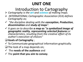
Unveiling the Art and Science of Cartography
Cartography is the intricate discipline of creating maps that visually communicate geographical information. A map serves as a symbolized image of reality, representing selected features on Earth's surface. This summary delves into the goals of cartography, the essential components of a well-designe
0 views • 65 slides

Comprehensive Guide to DESE MAP-A Teacher Orientation 2021-22
Explore the detailed orientation program for teachers on the Missouri Assessment Program-Alternate (MAP-A) by the Department of Elementary and Secondary Education (DESE). Learn about eligibility criteria, assessment procedures, compliance requirements, and instructional strategies for MAP-A. Discove
0 views • 25 slides
MAP Reports for Effective Student Assessment
Dive into the world of MAP Reports at Lathrop Intermediate School to learn how to run reports, interpret data, set goals, and track student progress. Discover different MAP report types, their purposes, and who can benefit from each one, empowering educators, counselors, parents, and administrators
0 views • 8 slides
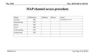
Proposed MAP Channel Access Procedures in IEEE 802.11-24/72r0
In the May 2024 document IEEE 802.11-24/72r0, a uniform MAP coordination framework is discussed, involving procedures like M-AP discovery, coordinated transmissions, and channel access mechanisms. All APs in a coordination group can compete for channel access and share transmission opportunities. Th
0 views • 10 slides
Messy Situational Map Template with Suggestions for Use
This SA template provides a messy situational map template along with suggestions for use. The initial map should be done by hand on a large piece of paper to allow for quick adjustments and capturing thoughts. The template includes an abstract map and a customizable version for creating more readab
0 views • 4 slides
Various Strategy Maps and Their Components
This content discusses different types of strategy maps including the Balanced Scorecard, Classic Kaplan/Norton Strategy Map, Generic Example Strategy Map, and Basic Strategy Map Background. Each map highlights different perspectives such as financial, customer, internal, and learning & growth, alon
0 views • 22 slides
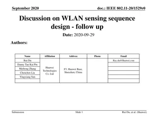
Analysis of WLAN Sensing Sequence Design Using Ambiguity Function and Range-Doppler Map
In this document, the authors from Huawei discuss the analysis of employing the ambiguity function for WLAN sensing sequence design. They delve into the ambiguity function's definition, analysis, and its comparison with the range-Doppler map. The document highlights the importance of ambiguity funct
0 views • 15 slides
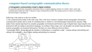
The Evolution of Cartographic Communication Theory in the Digital Age
Cartographic communication theory in digital mapping involves two models: the static map communication model and the interactive map communication model. The static map model follows traditional map-making methods adapted to digital tools, while the interactive map model leverages user feedback to r
0 views • 8 slides

Sets, Maps, and Map Methods
Explore the concepts of sets, maps, and map methods in programming, focusing on efficient operations like adding, removing, and searching for values. Sets allow unique values with no duplicates, while maps hold key-value pairs like a dictionary. Map methods provide functions for manipulating mapping
0 views • 5 slides
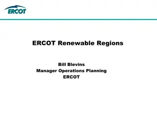
Overview of ERCOT Renewable Regions and Zone Map
ERCOT, managed by Bill Blevins, divides into seven solar and wind regions including North, South, East, West, Panhandle, Coast, and Houston. This division aids operations planning and management. The Renewable Regions Map and Zone Map play key roles in GIS status reporting and meeting presentations,
0 views • 4 slides

Introduction to Spark in The Hadoop Stack
Introduction to Spark, a high-performance in-memory data analysis system layered on top of Hadoop to overcome the limitations of the Map-Reduce paradigm. It discusses the importance of Spark in addressing the expressive limitations of Hadoop's Map-Reduce, enabling algorithms that are not easily expr
0 views • 16 slides
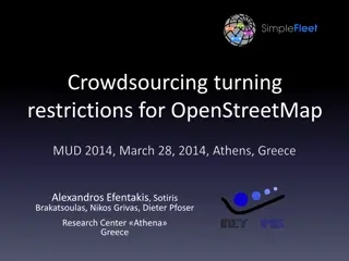
Enhancing OpenStreetMap with Crowdsourced Turning Restrictions
Abundance of GPS tracking data has led to significant research on map-matching algorithms and identifying turning restrictions. This study focuses on inferring turning restrictions for OpenStreetMap data by utilizing historic map-matching results effectively. Understanding and implementing turning r
0 views • 25 slides