European Hydrographic Activities and Marine Data Initiatives
IRCC-9 in Paramaribo discussed the IHO-EU Network Working Group's efforts to monitor and manage hydrographic aspects. The Coastal Mapping project aims to enhance digital mapping in the EU while EMODNet provides access to marine data. Improving cooperation with EU Directorates-General and monitoring EU directives for maritime policies are essential for progress. The collaborative achievements among Hydrographic Offices show promise for future development in European marine knowledge and policy-making.

Download Presentation

Please find below an Image/Link to download the presentation.
The content on the website is provided AS IS for your information and personal use only. It may not be sold, licensed, or shared on other websites without obtaining consent from the author. Download presentation by click this link. If you encounter any issues during the download, it is possible that the publisher has removed the file from their server.
E N D
Presentation Transcript
IRCC-9 Paramaribo 13th of June 2017 IHO-European Union Network Working Group (IENWG)
Background IHO-EU MoU signed in 2012 at the XVIIIthIHC Established by IRCC to monitor and deal with the activities and processes related to hydrographic aspects under the aegis of the European Union (EU) Membership: IHO focal points for RHCs with EU/EEA members. Associate members: any other RHCc and nations
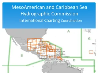
Coastal Mapping project 18 partners (11 HOs) Assess the current availability of digital coastal mapping in the EU Disseminate this information through EMODnet http://www.emodnet.eu/coastal-mapping Share experience of coastal mapping in the EU Develop recommendations from best practices Propose way forward
European Marine Observation and Data Network (EMODNet) Long term marine data initiative by the DG MARE underpinning the EU Marine Knowledge 2020 strategy Seven operational sub-portals providing access to marine data in: geology, physics, chemistry, biology, seabed habitats and human activities High resolution seabed mapping contract awarded in December 2016 http://www.emodnet.eu/
Improve cooperation with EU Directorates-General Promoting the role of the hydrographic offices in development of EU maritime policies Good engagement with DG-MARE Tto extend to other DGs: ENV, MOVE, RTD, REGIO, GROW
Monitor EU directives and call for tenders and proposals, prjects, events Inspire directive Development of geographical data infrastructure Maritime Strategy Framework Directive Protection of the marine environment across Europe Maritime Spatial Planning directive Consistent management of maritime space Cross borders, cross sectors Pilote cross border studies SIMCelt, SIMWestMed, SIMNorAt, SUPREME
Achievements and future development Sharing views amongst HOs and cooperation for answering European calls for tenders HOs input for marine knowledge European policy better understood by DG-MARE IENWG considers to focus on systematic high quality data acquisition and aggregation
Action required from IRCC RCC is invited to note this report;