Atlanta Region Geospatial Community Meeting on March 7, 2018
The Atlanta Region Geospatial Community Meeting on March 7, 2018, will cover various topics including updates on the Atlanta Region Open Data Program, Georgia GIO, and mapping at Atlanta Public Schools. The agenda includes lightning rounds and discussions on utilizing Google Street View, closed data importance, and personal success tips in GIS. Updates and announcements will focus on LUCA participation, BAS updates, and career opportunities in GIS. Don't miss this informative event happening at the ARC Conference Center Plaza Level!

Download Presentation

Please find below an Image/Link to download the presentation.
The content on the website is provided AS IS for your information and personal use only. It may not be sold, licensed, or shared on other websites without obtaining consent from the author. Download presentation by click this link. If you encounter any issues during the download, it is possible that the publisher has removed the file from their server.
E N D
Presentation Transcript
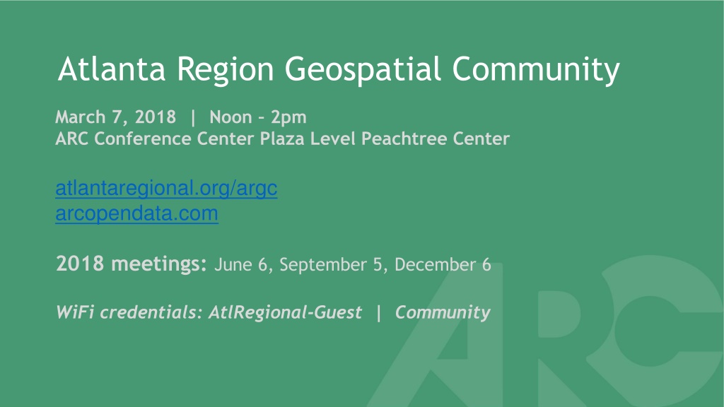
Atlanta Region Geospatial Community March 7, 2018 | Noon 2pm ARC Conference Center Plaza Level Peachtree Center atlantaregional.org/argc arcopendata.com 2018 meetings: June 6, September 5, December 6 WiFi credentials: AtlRegional-Guest | Community
ARGC Meeting Materials atlantaregional.org/argc
Agenda Lunch, networking, poster gallery Introduction, updates and announcements Atlanta Region Open Data Program Georgia GIO Update on 3DEP LiDAR, Google Statewide Imagery & More Susan Miller, Georgia Geospatial Information Office Mapping and Data Use at Atlanta Public Schools John Keltz, Atlanta Public Schools Lightning Rounds Making the Most of Google s Street View Camera Loan Program Chris Rice, InterDev/ City of Tucker The Importance of Closed Data, and other Tips to Ensure Personal Success in GIS Carlo Frate, InterDev/ City of Chamblee Future topics Poster gallery Q & A Adjourn
Updates and Announcements LUCA Update 100% Participation in Atlanta Region all 10 counties, 54/73 cities registered, 15 more cities working with county and 4 with another RC Data started shipping end of February Shipments staggered from now until early April Shipment will be accompanied by an email, check Spam Passwords and SWIM token will come by USPS letter DVDs will come Fed Ex Title 13 data, TIGER data, GUPS Updates due 120 days from date of receipt GA Power customer addresses by county being geocoded right now
Updates and Announcements BAS Update 2018 BAS currently in progress First deadline was March 1st, Final deadline is May 31st Annual opportunity to submit annexations, de-annexations, boundary changes, road updates, etc
Updates and Announcements Georgia State GIO Google Imagery for local and State government 6 , 3 band, almost all of region 2017, mixed leaf on/off Free registration required How to use Career Opportunities City of Atlanta Department of Watershed Management seeking GIS Technical Supervisor Interdev seeking a part-time GIS Technician to staff City of Sandy Springs ARC Mobility Services Group seeking Transit Planning & Implementation intern Others? (Events next)
Upcoming Events TAG Transportation Tech Presents Autonomous Atlanta: Connected City in an Autonomous World Event ($10 with discount code: guest) March 8, 5:30-8pm, ARC Conference Center SAFE FME World Tour user meeting April 12, 2018 Southern Data Science Conference April 12-14, Atlanta Mapbox Locate Conference May 30-31, San Francisco Monthly GAURISA luncheon Second Tuesday, rotating locations Monthly Georgia GIS Coordinating Committee meeting Third Wednesday, rotating locations Others?
ARGC Participation GISP Points First-time applicants Renewing 2 hours* Attendance 2 hours** 6 months to a year membership 1 point 3 points Presentation or poster display * 4 Professional Activity hours = .1 point for first-time applicants ** 6 Professional Activity hours = 1 point for renewing applicants 1 point 3 Points
Baltimore Metropolitan Council Regional GIS Data Center AR Open Data Program Boston Region MPO Data Catalog Capital Area (Austin, TX) COG Regional Open Data Chicago Metropolitan Agency for Planning Data Hub City of Brampton, Ontario GIS Data Center Invitation to join Open Data Council Collaborate on current and future needs Peer review Policy and governance Technical deployments Summary paper Report back Join us! Data Driven Detroit Open Data Portal Denver Regional Data Catalog Des Moines Metropolitan Planning Organization Research, Stats, and Data Hub East-West Gateway Council of Governments (Greater St. Louis) Research Center Houston-Galveston Area Council GIS Datasets Los Angeles GeoHub Louisville/Jefferson County Information Consortium Maricopa Association of Governments (Greater Phoenix) Open Data Metropolitan (San Francisco Bay Area) Transportation Commission Open Data Metropolitan Council of Minneapolis and St. Paul MetroGIS New York City Open Data North Texas Council of Governments Regional Data Center SANDAG (San Diego region) Data Surfer Seattle Open Data Triangle J Council of Governments Regional Data Center (Research Triangle in NC)