Revolutionizing Marine Mammal Detection using Geospatial Artificial Intelligence
Delve into the groundbreaking development of an operational system utilizing geospatial artificial intelligence to detect marine mammals in very high-resolution satellite imagery. Explore the global interest, monitoring platforms, proof of concept, limitations, future possibilities, and innovative a
0 views • 20 slides

Geospatial Knowledge: Shaping the Future of Digital Society
Exploring the pivotal role of geospatial knowledge in tomorrow's global digital society, the Geospatial Knowledge Infrastructure (GKI) Project aims to advance the integration of digital economies, societies, and citizens through location-based services and technologies. With a focus on stakeholder e
1 views • 23 slides

Overview of AFRIGIST's Capacity Building Activities
AFRIGIST, the African Regional Institute for Geospatial Information Science and Technology, aims to provide quality training and education in geospatial science to enhance sustainable development in Africa. Established under the United Nations Economic Commission for Africa, AFRIGIST focuses on deve
1 views • 20 slides
Standard Data File Formats for Geospatial Instruments
Understanding the importance of standard file formats for GNSS, total stations, automatic levels, and relative gravimeters to facilitate data exchange, processing, and preservation in the geospatial industry. Exploring the significance of RINEX and other XML-based formats, along with examples and th
2 views • 30 slides

Evolution of ASPRS Positional Accuracy Standards for Geospatial Data
New technological advancements have prompted the need for updated ASPRS positional accuracy standards for digital geospatial data. Legacy standards from the 1990s are no longer sufficient given the shift towards modern mapping technologies. The new era of mapping involves factors like camera calibra
0 views • 21 slides

Geospatial Technology Services at University of Edinburgh
The University of Edinburgh, through its Information Services, specializes in developing and delivering projects involving geospatial technology. They offer the Digimap Service, providing online access to maps and geospatial data. The university subscribes to the Eduserv Chest Agreement for Esri pro
1 views • 29 slides

International Hydrographic Organization Report Summary
The report highlights the activities and achievements of the NATO Geospatial Maritime Working Group (GMWG) in 2018/19, focusing on providing maritime geospatial standards, governance, production support, and operational information. It discusses the progress and key outcomes of the NATO AML Co-Produ
0 views • 13 slides

National Geospatial Information Management Strategy Action Plan Update
The National Geospatial Information Management Strategy Action Plan Update outlines five strategic goals focusing on governance, data, access, interoperability, and development. Under each goal, multiple action points are detailed, including reviewing council roles, updating legislation, coordinatin
4 views • 13 slides

Empowering Women in Geospatial Information: A Look at Fiji and the Pacific
Explore the impactful role of women in geospatial information management in Fiji and the Pacific region through the leadership, achievements, and future prospects highlighted in the article. From Meizyanne Hicks leading the way to the significant contributions by women in the geospatial industry, th
0 views • 6 slides

NGAC Geospatial Workforce Development Subcommittee Activities Overview
The NGAC Geospatial Workforce Development Subcommittee's purpose is to provide recommendations for developing a skilled geospatial workforce. The subcommittee members are actively involved in various activities such as examining STEM education synergies, reviewing federal job classification codes, a
0 views • 12 slides
Working Group-4: Integrated Geospatial Information Framework (IGIF) Activities Overview
This content details the activities and plans of Working Group-4 related to the Integrated Geospatial Information Framework for the years 2022-2024. It includes strategies for raising awareness, sharing best practices, preparing action plans, training initiatives, and organizing workshops. The group
0 views • 5 slides

Geospatial Database Development for KRISHI Portal: Nodal Officers Workshop
Geospatial databases play a crucial role in providing location-specific agricultural services through the KRISHI Portal. This workshop focuses on the core objective of the portal, simple GeoPortal architecture, main services offered, the significance of geospatial data, and the utilization of spatia
0 views • 45 slides
Geospatial Summit Feedback and Transition Needs for US Army Corps of Engineers
Feedback and preparation for the new datums discussed at the 2015 Geospatial Summit by US Army Corps of Engineers, highlighting advantages, challenges, and transition tools and outreach needs for the organization. Emphasis is placed on the importance of vertical datums consistency, relationship impr
1 views • 4 slides

Evolution of Geospatial Governance in the United States
Geospatial governance in the United States has evolved over the years, with key milestones such as the establishment of the Geographic Board, the National Spatial Data Infrastructure, and the role of Federal agencies in surveying and mapping activities. Significant reports have highlighted the need
1 views • 11 slides

Geospatial Portfolio Management and NGDA Themes Overview
Explore the roles and responsibilities of Theme Leads, Dataset Managers, and the Investment Collaboration Process in Geospatial Portfolio Management. Understand the significance of National Geospatial Data Assets (NGDA) Themes, Theme Lead Agency roles, and the proposed NGDA Themes for effective port
0 views • 17 slides
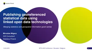
Development of Guidelines for Publishing Georeferenced Statistical Data Using Linked Open Data Technologies
Development of guidelines for publishing statistical data as linked open data, merging statistics and geospatial information, with a primary focus on preparing a background for LOD implementation in official statistics. The project aims to identify data sources, harmonize statistical units, transfor
3 views • 31 slides
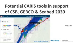
Enhancing Geospatial Imaging Solutions with CARIS Tools for Seabed Mapping
CARIS offers a suite of tools including CARIS Cloud and BDB Server, facilitating the seamless upload, processing, and transfer of bathymetric data to support initiatives like Seabed 2030 and GEBCO. The integration of CARIS tools enables stakeholders to manage, disseminate, and access hydrospatial da
0 views • 5 slides

UN-GGIM Private Sector Network: Enhancing Global Geospatial Initiatives
The UN-GGIM Private Sector Network (PSN) serves as a platform for private sector collaboration with Member States on geospatial initiatives. The PSN aims to enhance the world's geospatial capabilities, support policy development, and address global challenges. It operates independently while alignin
0 views • 17 slides

Geospatial Private Sector in Africa: Opportunities and Challenges
The geospatial private sector in Africa faces challenges due to its small and disjointed nature, with a focus mainly on multinational corporations. Initiatives like UN-GGIM are encouraging private sector participation at national and continental levels. Efforts are being made to include the private
0 views • 6 slides
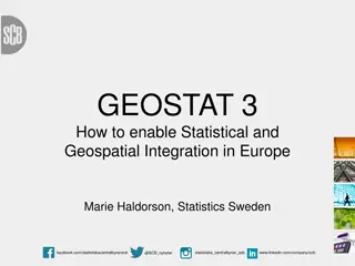
GEOSTAT.3: Statistical and Geospatial Integration in Europe
Explore the GEOSTAT project, focusing on developing the European adaptation of the ESS-SGF and its implementation in EU member states. Key objectives include testing the ESS-SGF for the 2030 Agenda and supporting EFGS initiatives. The project involves a collaborative effort by various NSIs, sub-cont
0 views • 16 slides

Geospatial and Statistical Data Integration in Rwanda: A Closer Look at RCMRD's Role
Explore the evolution of geospatial and statistical data integration in Rwanda, focusing on the initiatives led by Dr. Emmanuel Nkurunziza, General Director of RCMRD. Discover how advancements in geospatial technologies and statistical systems are shaping sustainable development in the region.
0 views • 14 slides

Cloud-based Geospatial Query Processing Using MapReduce and Voronoi Diagrams
This research paper presents a cloud-based approach for processing geospatial queries efficiently using MapReduce and Voronoi diagrams. The motivation behind the study, related works in the field, preliminary concepts of MapReduce, Voronoi diagram creation, query types, performance evaluation, and f
0 views • 30 slides
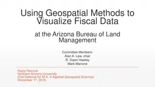
Geospatial Visualization of Fiscal Data at Arizona BLM
Enhancing operational excellence at the Bureau of Land Management (BLM) through geospatial methods to connect budget allocations and spending with field offices in Arizona. Utilizing GIS tools, data spatially represents budget planning, workload execution, and resource distribution for informed deci
0 views • 25 slides

Recent Developments in Marine Geospatial Information Management
The Baltic Sea Hydrographic Commission and related activities highlight significant developments in marine geospatial information management, including upcoming council meetings, GEBCO initiatives, and UN-GGIM endorsements of integrated marine geospatial frameworks. These efforts aim to enhance data
4 views • 8 slides

Geospatial Training Modules and Project Updates
Updates on guest speakers, module assignments, and important deadlines. Choose training modules for your project, create effective posters, and learn about geocoding and map integration. Engage in interactive quizzes to enhance your geospatial skills.
0 views • 10 slides
Regional Geospatial Data Infrastructures Coordination and Promotion Efforts
This initiative aims to coordinate and promote the development of Geospatial Data Infrastructures (SDIs) in the UN-GGIM Americas Member States. Activities include diagnosing the current status of SDIs, designing evaluation tools, sharing regional best practices, and conducting training sessions to e
0 views • 8 slides
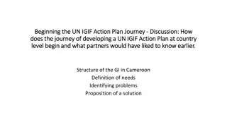
Development of UN-IGIF Action Plan in Cameroon: Addressing Geospatial Data Governance Challenges
The journey of developing a UN-IGIF Action Plan at the country level in Cameroon begins with identifying stakeholders and common strategic priorities, mobilizing support, setting up project teams, drafting action plans, and organizing workshops. The lack of coordination among geospatial information
0 views • 4 slides

Northern Utah GIS Workforce Survey 2014 Results Overview
The Northern Utah GIS Workforce Needs Survey Results for 2014 provide insights into the demographics, industry experience, survey respondents by county in Utah, and educational requirements for GIS/geospatial technicians. The survey highlights the distribution of position titles, length of experienc
1 views • 26 slides
International Hydrographic Organization HSSC-11 Report Highlights
The report from the Hydrographic Services and Standards Committee provides insights into the activities, achievements, and vision of the Defence Geospatial Information Working Group (DGIWG). Key topics include the DGIF/NGIF relationship, implications for nations, standardized mappings, model mainten
0 views • 8 slides
Geospatial Video Search and Viewable Scene Modeling
Explore the innovative research on georeferenced video search and viewable scene modeling. Learn about automatic annotation, camera direction modeling, data acquisition, and indexing for enhanced video retrieval. The study focuses on capturing the field-of-view, meta-data acquisition, and synchroniz
0 views • 15 slides
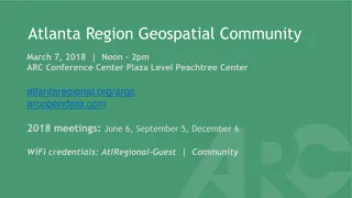
Atlanta Region Geospatial Community Meeting on March 7, 2018
The Atlanta Region Geospatial Community Meeting on March 7, 2018, will cover various topics including updates on the Atlanta Region Open Data Program, Georgia GIO, and mapping at Atlanta Public Schools. The agenda includes lightning rounds and discussions on utilizing Google Street View, closed data
0 views • 9 slides
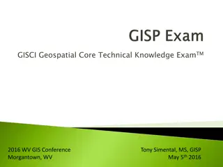
GISCI Geospatial Core Technical Knowledge Exam - Overview and FAQs
Explore key information about the GISCI Geospatial Core Technical Knowledge Exam, such as how it's structured, what's covered, exam preparation materials, passing score, exam offerings, registration details, recertification, and more. Get insights from Tony Simental, the WV State GIS Coordinator, on
1 views • 11 slides

Recent Developments in Geospatial Information Management in the Asia-Pacific Region
Key events include the Executive Board Meeting in Singapore, the 11th Plenary Meeting in India, Fourth Ministerial Conference on Space Applications in Indonesia, workshops on geospatial information sharing, and UN-GGIM-AP's contribution to the global geodesy agenda. Activities such as elections, wor
0 views • 9 slides
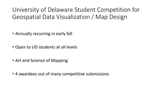
University of Delaware Student Competition for Geospatial Data Visualization
Annual student competition at University of Delaware for geospatial data visualization and map design, open to students at all levels. Winner of 2021: Loonibha Manandhar, with honorable mentions to Anthony Chan, Matthew Hardy, and James Blount. A platform for showcasing the art and science of mappin
0 views • 4 slides
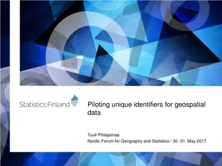
Piloting Unique Identifiers for Geospatial Data - Nordic Forum Presentation
Presentation at the Nordic Forum for Geography and Statistics on piloting unique identifiers for geospatial data by Tuuli Pihlajamaa. The agenda included terms used, background for the pilot, aims, results, and future plans. Detailed discussions on terms like URI, RDF, JHS 193, INSPIRE guidelines, a
0 views • 15 slides
Enhancing Geospatial Information Web Services in Tehran, Iran
Explore the latest in spatial web services provided by NGIAs in Tehran, Iran, at the Second UN-GGIM-AP Plenary Meeting. Discover the key features, challenges, and future works of the geospatial information platform, along with its data services, use cases, and policies. Get insights into the service
0 views • 9 slides

Spatial Analysis of Sex Trafficking and Post-Trauma Service Providers in the United States
This study delves into the spatial relationship between sex trafficking and post-trauma service providers in the continental United States. It highlights concerning statistics on human trafficking, survivors' needs, and the critical role of non-profit organizations in supporting survivors. The resea
0 views • 11 slides
Open Source Mapping for Earthquake Risk Assessment and Reduction
This study explores the use of open-source mapping tools for earthquake risk assessment and reduction, emphasizing the importance of utilizing Free and Open Source Software (FOSS) in disaster management. By leveraging freely available geospatial data and software, individuals can identify vulnerable
0 views • 18 slides
Progress Update on Portfolio Management Action Plan for National Geospatial Advisory Committee Meeting
The update entails the implementation status of the A-16 Portfolio Management Action Plan discussed at the National Geospatial Advisory Committee Meeting on June 6, 2013. Key points include GAO recommendations, team approach strategies, action plans, and the status of implementing these actions. Not
0 views • 8 slides
Assessment of Geospatial Data Readiness for SDG Monitoring in African Countries
Quick assessment conducted during the workshop in Addis Ababa, Ethiopia, revealed the utilization of geospatial data for national and regional planning among African countries. Findings indicate the availability of fundamental geospatial datasets, highlighting the importance of incorporating geoinfo
0 views • 18 slides