Standard Data File Formats for Geospatial Instruments

Standard Data File Formats for GNSS,
Total Stations, Automatic Levels, and
Relative Gravimeters
Dan Gillins, Ph.D.
, P.L.S.
Geodesist, National Geodetic Survey
May 5, 2021
1
Daniel.Gillins@noaa.gov
Outline
1.
Background on why we need standard file formats
2.
Problem statement and objectives
3.
RINEX 3 as standard for raw GNSS data
4.
Other XML-based file formats as standards
1.
GVX – GNSS vectors
2.
CVX – Classical (angles/distances)
3.
LVX – Leveling
4.
RGX – relative gravity
2
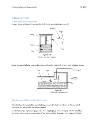
Why Standard File Formats?
•
Differing instrument manufacturers output data in varying file formats
(often proprietary, closed-source)
•
Standardization benefits:
•
Broadens use; easier to work with by others who will use the data
•
Easier to share with others
•
Reduces the need to convert from one format to another
•
Data in proprietary format can be converted to open, standard format
•
Increases likelihood critical metadata is captured and accurate; significant
figures are preserved
•
Lengthens the preservation of the data
•
Can be made machine-readable
3
Examples of Standard File Formats
•
RINEX
= Receiver Independent Exchange Format
•
v. 1 (1989) by Werner Gurtner (University of Bern); initial proposal
•
v. 2 (1990) by Gurtner and Gerald Mader (NGS); added GLONASS, SBAS, later
Galileo
•
v. 3 (2007) by Gurtner and Estey (UNAVCO); full support of all GNSS signals and
constellations
•
Aimed for the easy exchange and processing of raw GNSS data
•
GNSS carrier-phase and pseudorange (code) measurements, and time
•
LAS
= LASer format
•
Proposed by the American Society of Photogrammetry and Remote Sensing
(ASPRS) in 2003
•
Open format used for exchanging point cloud data
4
Problem Statement
NGS is developing:
1.
M-PAGES
– baseline processing engine for multi-GNSS data
•
M-PAGES provides its best solutions with RINEX 3
•
RINEX 3 is the international standard for raw GNSS data, and many IGS stations only provide
RINEX 3 files
•
But the NOAA CORS Network currently archives data in RINEX 2, and many current workflows
at NGS process RINEX 2 data files
2.
OPUS
– software for managing, processing, and adjusting survey data
•
(Note M-PAGES will become the baseline processing engine in OPUS)
•
OPUS-Projects v. 5 supports GNSS vectors, such as Real-time Kinematic (RTK) vectors
•
OPUS v. 6 will support survey data from total stations, automatic levels, and relative gravimeters
•
But there is a lack of a well-accepted, industry-wide standard file format for GNSS vectors, total
stations, levels, and gravimeters
5
Objectives
6
1.
Adopt RINEX 3 as the standard file format for raw GNSS data
•
Require submission/uploading of RINEX 3 data files to NGS
2.
Develop new standard file formats:
•
GVX: GNSS Vector Exchange Format
•
CVX: Classical Vector Exchange Format (angles, distances)
•
LVX: Leveling Vertical Exchange Format
•
RGX: Relative Gravity Exchange Format
RINEX 3
7
Background on RINEX 3
•
Originally released in 2007
•
The international scientific standard for exchanging raw GNSS data
•
Endorsed by the IGS and RTCM
•
Actively maintained and updated (current version is 3.05)
•
Supports all GNSS signals and constellations
•
Enables unambiguous use of all observables and application of modern
GNSS products (e.g., Bias-SINEX)
•
M-PAGES is designed to best support RINEX 3 data files, although it can
also process RINEX 2 data files.
–
If you want the best multi-GNSS solution, you will want to work with RINEX 3
8
RINEX 2 versus RINEX 3
RINEX 2 Observables
RINEX 3 Observables
9
RINEX 2 versus RINEX 3
RINEX 2 Observables
RINEX 3 Observables
10
NGS and RINEX 3
•
In the near future (
date to be determined
),
NGS will only support RINEX 3 for its
products and services which rely upon raw
GNSS data, with some exceptions
•
NGS will be releasing a Federal Register
Notice for notification and public commenting
11
NOAA CORS Network and RINEX 3
•
Each CORS must be capable of providing:
–
RINEX 3 file
–
Binary exchange (BINEX) file
–
Raw proprietary data file
•
NGS will archive the RINEX 3 files at each CORS
–
When necessary, NGS will convert the BINEX file to RINEX 3
–
Raw GNSS data currently stored by NGS will remain in its
earlier version of RINEX (no up-conversion)
12
For QC purposes
For QC purposes and/or
when communication
link is too slow to
upload RINEX 3
directly
What is BINEX?
•
“BINary EXchange”
•
Existed since 2000
•
Binary standard for GNSS research and operational
purposes
•
Collaborative format, partnering UNAVCO with numerous
receiver manufacturers
•
Ongoing design, aims to incorporate RINEX, SINEX,
IONEX, SP3, etc.
•
Compact and fast
13
OPUS and RINEX 3
•
NGS will recommend and encourage use of
RINEX 3 for OPUS
–
Provides the best multi-GNSS solutions
•
NGS will continue to allow use of RINEX 2 in
OPUS for legacy data and equipment
•
NGS will discontinue support of non-RINEX
data submissions to OPUS
14
Development of XML-Based
Standard File Formats
15
XML-Based Standard File Formats
16
OPUS-Projects
•
Free, web-based software
•
Online training available
•
Designed for managing campaign-style GPS surveys
•
Multiple repeat occupations of several marks
•
Ability to add GPS data from NOAA CORS Network
or IGS Network
•
Session baseline processing using PAGES
•
Customize tropospheric delay models, elevation cutoff masks, constraint
weighting
•
Network least squares adjustments of multiple sessions
•
Choice of reference frames and geoid models
•
Currently requires ≥ 2-hour static GPS observation for post-processing
17
OPUS-Projects v. 5
•
Inclusion of previously processed GNSS vectors
–
Single-base RTK vectors
–
Network RTK vectors
–
Vectors processed in other software
•
Allows QA/QC of uploaded vectors
•
Automatically “weights” uploaded vectors in a network least
squares adjustment
•
Final adjustment results can be submitted to NGS for publication
•
Released to Beta for external testing. Available at:
https://beta.ngs.noaa.gov/OPUS-Projects/OpusProjects.shtml
•
Webinar scheduled for May 20, 2021
18
G
NSS
V
ector E
X
change Format (GVX)
Website:
https://www.ngs.noaa.gov/data/formats/GVX/index.shtml
•
Detailed documentation
•
Schema (XSD)
•
Example vector file
GVX is written in Extensible Markup Language (XML)
•
Designed to store and carry data in plain text format
•
Flexible representation of arbitrary data structures
•
Extensible – new elements can be added later without breaking applications
•
Both machine-readable and human-readable
•
Schemas can be used to define “must haves” and “should haves”
19
G
NSS
V
ector E
X
change Format (GVX)
Timeline
•
Solicited internal and external feedback for GVX since 8/2019
•
Introduced to industry in 10/2019; solicited feedback
•
Addressed all comments and feedback
•
Released version 1.0 to industry in 02/2021
Some important details:
•
All start and stop times must be in GPS time
•
Distance must be in meters
•
Angles must be in decimal degrees
•
Follow IGS naming conventions for antenna names
•
Follow ISO Geodetic Register for reference systems
G
NSS
V
ector E
X
change Format (GVX)
1.
SOURCE_DATA
(
source of data file, conversion software)
2.
PROJECT_INFORMATION
(project title, agency, party chief, etc.)
3.
REFERENCE_SYSTEM
(reference frame for coordinates and orbits; IDs from ISO
Geodetic Registry)
4.
EQUIPMENT
(antenna and receiver types, serial numbers, calibration metadata,
firmware)
5.
SURVEY_SETUP
(solution type, processing software, corrector format, RTN IP
address and port, operator)
6.
POINT
(coordinates and uncertainties, point type)
7.
GNSS_VECTOR
(differential components and correlation matrix, start and stop
time, quality metrics such as mask, DOP, satellites used, orbit info.)
8.
SESSION
(intra-vector or cross-correlations matrix for simultaneous baseline
processing)
21
Industry Invited to Provide Feedback
22
•
Released GVX v. 1.0 released to industry on February 4, 2021
•
Over 30 people attended mtg
How will NGS use GVX?
23
Design for OPUS-Projects and GVX
[Adapted from Weaver et al. 2018]
GVX file
(from RTK survey
or baseline processing in
other software)
OPUS-Projects
(from static
GNSS session processing)
RTK Base or
“From” Mark
RTK Rover or
“To” Mark
Vector
Vector in GVX File
24
24
Other XML-based File Formats
•
GVX sets template for other XML standard file formats
•
CVX = classical (angles/distances)
•
LVX = leveling
•
RGX = relative gravity
•
Working with industry to adopt all of these common file
formats, and goal is to make OPUS v.6 capable of using them
•
Aim to take these files to international community for adoption
or inclusion in GeodesyML
25
Oregon Dept. of Transportation Study
•
SPR304-821 -- Simpson et al. (2021)
•
ODOT funded study by Oregon State
University
•
Updated survey standards and control
guidance for improved operations
•
RTN measurements
•
Total stations
•
Leveling
•
Integrated networks for adjustment
26
CVX: Classical Vector Exchange
1.
SOURCE_DATA
2.
PROJECT_INFORMATION
3.
REFERENCE_SYSTEM
4.
UNITS
(global definition of units in the file)
5.
CLASSICAL_EQUIPMENT
(instrument make/model, white paper
specifications, target make/model)
6.
INSTRUMENT_CORRECTIONS
(
compensator, vertical index, automatic
pointing, collimation, etc.)
7.
POINT
8.
CLASSICAL_SET
(weather, ppm, horizontal and vertical angles, distance,
sigmas, instrument faces, target offset, measurement mode, distance type)
27
LVX: Leveling Vertical Exchange
28
1.
SOURCE_DATA
2.
PROJECT_INFORMATION
3.
REFERENCE_SYSTEM
4.
VERTICAL_DATUM
(datum for heights with IDs per ISO Geodetic Registry)
5.
UNITS
6.
LEVELING_EQUIPMENT
(instrument make/model, serial number, white paper
specifications, and rod(s) make/model/material, white paper specs., calibration info.)
7.
COLLIMATION
(applied collimation value from peg test)
8.
FIELD_ACCURACY_TEST
(results of a field test on accuracy of leveling equip.)
9.
POINT
10.
LEVELING_SECTION
(elevation difference, running distance, running imbalance,
operator, start and stop time, temp. probes, maximum instrument height, weather, total
setups, leveling method, individual setups with backsight, foresight, stadia wires, and
reading mode)
(NOTE: supports electronic, optical, 3-wire, and micrometer)
Summary
•
NGS will adopt RINEX 3 for raw GNSS data
•
Other XML-based formats developed or under development
•
GVX: GNSS Vectors (released in 02/2021)
•
CVX: Classical (angles/distances)
•
LVX: Leveling
•
RGX: Relative Gravity
•
Schemas will be written for all
•
Feedback and ideas are welcome!
29
Plan to release in 2022
Questions?
•
Daniel.Gillins@noaa.gov
30
Understanding the importance of standard file formats for GNSS, total stations, automatic levels, and relative gravimeters to facilitate data exchange, processing, and preservation in the geospatial industry. Exploring the significance of RINEX and other XML-based formats, along with examples and the current challenges faced by NGS in transitioning to newer standards.

Download Presentation

Please find below an Image/Link to download the presentation.
The content on the website is provided AS IS for your information and personal use only. It may not be sold, licensed, or shared on other websites without obtaining consent from the author. Download presentation by click this link. If you encounter any issues during the download, it is possible that the publisher has removed the file from their server.
E N D
Presentation Transcript
Standard Data File Formats for GNSS, Total Stations, Automatic Levels, and Relative Gravimeters Dan Gillins, Ph.D., P.L.S. Geodesist, National Geodetic Survey May 5, 2021 Daniel.Gillins@noaa.gov 1
Outline 1. Background on why we need standard file formats 2. Problem statement and objectives 3. RINEX 3 as standard for raw GNSS data 4. Other XML-based file formats as standards 1. GVX GNSS vectors 2. CVX Classical (angles/distances) 3. LVX Leveling 4. RGX relative gravity 2
Why Standard File Formats? Differing instrument manufacturers output data in varying file formats (often proprietary, closed-source) Standardization benefits: Broadens use; easier to work with by others who will use the data Easier to share with others Reduces the need to convert from one format to another Data in proprietary format can be converted to open, standard format Increases likelihood critical metadata is captured and accurate; significant figures are preserved Lengthens the preservation of the data Can be made machine-readable 3
Examples of Standard File Formats RINEX = Receiver Independent Exchange Format v. 1 (1989) by Werner Gurtner (University of Bern); initial proposal v. 2 (1990) by Gurtner and Gerald Mader (NGS); added GLONASS, SBAS, later Galileo v. 3 (2007) by Gurtner and Estey (UNAVCO); full support of all GNSS signals and constellations Aimed for the easy exchange and processing of raw GNSS data GNSS carrier-phase and pseudorange (code) measurements, and time LAS = LASer format Proposed by the American Society of Photogrammetry and Remote Sensing (ASPRS) in 2003 Open format used for exchanging point cloud data 4
Problem Statement NGS is developing: 1. M-PAGES baseline processing engine for multi-GNSS data M-PAGES provides its best solutions with RINEX 3 RINEX 3 is the international standard for raw GNSS data, and many IGS stations only provide RINEX 3 files But the NOAA CORS Network currently archives data in RINEX 2, and many current workflows at NGS process RINEX 2 data files 2. OPUS software for managing, processing, and adjusting survey data (Note M-PAGES will become the baseline processing engine in OPUS) OPUS-Projects v. 5 supports GNSS vectors, such as Real-time Kinematic (RTK) vectors OPUS v. 6 will support survey data from total stations, automatic levels, and relative gravimeters But there is a lack of a well-accepted, industry-wide standard file format for GNSS vectors, total stations, levels, and gravimeters 5
Objectives 1. Adopt RINEX 3 as the standard file format for raw GNSS data Require submission/uploading of RINEX 3 data files to NGS 2. Develop new standard file formats: GVX: GNSS Vector Exchange Format CVX: Classical Vector Exchange Format (angles, distances) LVX: Leveling Vertical Exchange Format RGX: Relative Gravity Exchange Format 6
RINEX 3 7
Background on RINEX 3 Originally released in 2007 The international scientific standard for exchanging raw GNSS data Endorsed by the IGS and RTCM Actively maintained and updated (current version is 3.05) Supports all GNSS signals and constellations Enables unambiguous use of all observables and application of modern GNSS products (e.g., Bias-SINEX) M-PAGES is designed to best support RINEX 3 data files, although it can also process RINEX 2 data files. If you want the best multi-GNSS solution, you will want to work with RINEX 3 8
RINEX 2 versus RINEX 3 RINEX 2 Observables RINEX 3 Observables 9
RINEX 2 versus RINEX 3 RINEX 2 Observables RINEX 3 Observables 10
NGS and RINEX 3 In the near future (date to be determined), NGS will only support RINEX 3 for its products and services which rely upon raw GNSS data, with some exceptions NGS will be releasing a Federal Register Notice for notification and public commenting 11
NOAA CORS Network and RINEX 3 Each CORS must be capable of providing: RINEX 3 file Binary exchange (BINEX) file Raw proprietary data file For QC purposes and/or when communication link is too slow to upload RINEX 3 directly For QC purposes NGS will archive the RINEX 3 files at each CORS When necessary, NGS will convert the BINEX file to RINEX 3 Raw GNSS data currently stored by NGS will remain in its earlier version of RINEX (no up-conversion) 12
What is BINEX? BINary EXchange Existed since 2000 Binary standard for GNSS research and operational purposes Collaborative format, partnering UNAVCO with numerous receiver manufacturers Ongoing design, aims to incorporate RINEX, SINEX, IONEX, SP3, etc. Compact and fast 13
OPUS and RINEX 3 NGS will recommend and encourage use of RINEX 3 for OPUS Provides the best multi-GNSS solutions NGS will continue to allow use of RINEX 2 in OPUS for legacy data and equipment NGS will discontinue support of non-RINEX data submissions to OPUS 14
Development of XML-Based Standard File Formats 15
XML-Based Standard File Formats Measurement Type File Format File Type Current Status Use at NGS Reduced GNSS data (GNSS vector) GVX XML Released final version 1.0 on 2/04/2021 OPUS-Projects v.5, OPUS v.6 Differential leveling (height differences) LVX XML Under development. Version 0.3 under review OPUS v.6 Classical (angles, distances) CVX XML Under development. Version 0.3 under review OPUS v.6 Relative gravity (gravity differences) RGX XML Planned for 2022 OPUS v.6 16
OPUS-Projects Free, web-based software Online training available Designed for managing campaign-style GPS surveys Multiple repeat occupations of several marks Ability to add GPS data from NOAA CORS Network or IGS Network Session baseline processing using PAGES Customize tropospheric delay models, elevation cutoff masks, constraint weighting Network least squares adjustments of multiple sessions Choice of reference frames and geoid models Currently requires 2-hour static GPS observation for post-processing 17
OPUS-Projects v. 5 Inclusion of previously processed GNSS vectors Single-base RTK vectors Network RTK vectors Vectors processed in other software Allows QA/QC of uploaded vectors Automatically weights uploaded vectors in a network least squares adjustment Final adjustment results can be submitted to NGS for publication Released to Beta for external testing. Available at: https://beta.ngs.noaa.gov/OPUS-Projects/OpusProjects.shtml Webinar scheduled for May 20, 2021 18
GNSS Vector EXchange Format (GVX) Website: https://www.ngs.noaa.gov/data/formats/GVX/index.shtml Detailed documentation Schema (XSD) Example vector file GVX is written in Extensible Markup Language (XML) Designed to store and carry data in plain text format Flexible representation of arbitrary data structures Extensible new elements can be added later without breaking applications Both machine-readable and human-readable Schemas can be used to define must haves and should haves 19
GNSS Vector EXchange Format (GVX) Timeline Solicited internal and external feedback for GVX since 8/2019 Introduced to industry in 10/2019; solicited feedback Addressed all comments and feedback Released version 1.0 to industry in 02/2021 Some important details: All start and stop times must be in GPS time Distance must be in meters Angles must be in decimal degrees Follow IGS naming conventions for antenna names Follow ISO Geodetic Register for reference systems
GNSS Vector EXchange Format (GVX) 1. 2. 3. SOURCE_DATA (source of data file, conversion software) PROJECT_INFORMATION (project title, agency, party chief, etc.) REFERENCE_SYSTEM (reference frame for coordinates and orbits; IDs from ISO Geodetic Registry) EQUIPMENT (antenna and receiver types, serial numbers, calibration metadata, firmware) SURVEY_SETUP (solution type, processing software, corrector format, RTN IP address and port, operator) POINT (coordinates and uncertainties, point type) GNSS_VECTOR (differential components and correlation matrix, start and stop time, quality metrics such as mask, DOP, satellites used, orbit info.) SESSION (intra-vector or cross-correlations matrix for simultaneous baseline processing) 4. 5. 6. 7. 8. 21
Industry Invited to Provide Feedback Released GVX v. 1.0 released to industry on February 4, 2021 Over 30 people attended mtg 22
How will NGS use GVX? Vendor 1 data file(s) GVX file(s) OPUS-Projects (least squares adjustment of vectors) GNSS vectors from real-time survey or post- processing of static data Vendor 2 data file(s) GVX file(s) submit NGS review & publication Vendor n data file(s) GVX file(s) 23
Design for OPUS-Projects and GVX GVX file (from RTK survey or baseline processing in other software) OPUS-Projects (from static GNSS session processing) RTK Base or From Mark RTK Rover or To Mark Vector in GVX File Vector [Adapted from Weaver et al. 2018]
Other XML-based File Formats GVX sets template for other XML standard file formats CVX = classical (angles/distances) LVX = leveling RGX = relative gravity Working with industry to adopt all of these common file formats, and goal is to make OPUS v.6 capable of using them Aim to take these files to international community for adoption or inclusion in GeodesyML 25
Oregon Dept. of Transportation Study SPR304-821 -- Simpson et al. (2021) ODOT funded study by Oregon State University Updated survey standards and control guidance for improved operations RTN measurements Total stations Leveling Integrated networks for adjustment 26
CVX: Classical Vector Exchange 1. 2. 3. 4. 5. SOURCE_DATA PROJECT_INFORMATION REFERENCE_SYSTEM UNITS (global definition of units in the file) CLASSICAL_EQUIPMENT (instrument make/model, white paper specifications, target make/model) INSTRUMENT_CORRECTIONS (compensator, vertical index, automatic pointing, collimation, etc.) POINT CLASSICAL_SET (weather, ppm, horizontal and vertical angles, distance, sigmas, instrument faces, target offset, measurement mode, distance type) 6. 7. 8. 27
LVX: Leveling Vertical Exchange 1. 2. 3. 4. 5. 6. SOURCE_DATA PROJECT_INFORMATION REFERENCE_SYSTEM VERTICAL_DATUM (datum for heights with IDs per ISO Geodetic Registry) UNITS LEVELING_EQUIPMENT (instrument make/model, serial number, white paper specifications, and rod(s) make/model/material, white paper specs., calibration info.) COLLIMATION (applied collimation value from peg test) FIELD_ACCURACY_TEST (results of a field test on accuracy of leveling equip.) POINT 10. LEVELING_SECTION (elevation difference, running distance, running imbalance, operator, start and stop time, temp. probes, maximum instrument height, weather, total setups, leveling method, individual setups with backsight, foresight, stadia wires, and reading mode) (NOTE: supports electronic, optical, 3-wire, and micrometer) 7. 8. 9. 28
Summary NGS will adopt RINEX 3 for raw GNSS data Other XML-based formats developed or under development GVX: GNSS Vectors (released in 02/2021) CVX: Classical (angles/distances) LVX: Leveling RGX: Relative Gravity Schemas will be written for all Feedback and ideas are welcome! Plan to release in 2022 29
Questions? Daniel.Gillins@noaa.gov 30


")
")
")