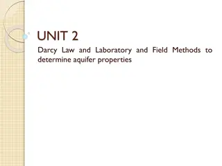
Understanding Groundwater Hydraulics and Hydrology
Explore the fundamentals of groundwater hydraulics and hydrology in this course, covering topics such as Darcy's law, aquifer testing, unsaturated flow, and more. Dive into practical applications and participate in a team project focusing on limiting hydraulic containment of contaminated aquifers. Gain hands-on experience in groundwater investigation and presentation skills.

Download Presentation

Please find below an Image/Link to download the presentation.
The content on the website is provided AS IS for your information and personal use only. It may not be sold, licensed, or shared on other websites without obtaining consent from the author. Download presentation by click this link. If you encounter any issues during the download, it is possible that the publisher has removed the file from their server.
E N D
Presentation Transcript
Introduction Groundwater Hydraulics Daene C. McKinney 1
Course Objectives Introduction to groundwater, including: Groundwater in the hydrologic cycle Characteristics of porous media Darcy's law of flow in porous media Continuity principles Well hydraulics and aquifer testing Applications of groundwater hydraulics Characteristics of unsaturated flow 2
Housekeeping Prerequisites: CE 356 Hydraulics Text: Groundwater Hydrology, Todd, David Keith, Larry W. Mays, John Wiley & Sons, 2004 Homework: Due dates on web site Excessively late (> 2 days) penalized 50% per day late Expectations: Clear presentation, No computational errors, Answers clearly marked, Units marked and used correctly Software: GroundwaterVistas (graphical interface for USGS MODFLOW) Available on CAEE Virtual Workspace 3
Housekeeping (Cont.) Grading: Exam 1: 17% Exam 2: 17% Homework: Project: 3 parts Part 1 5% Part 2 10% Part 3 19% Letter grades will be assigned as follows: A 92 100% A- 89 91% B+ 86 88% B 82 85% B- 79 81% C+ 76 78% C 70 75% C- 67 69% D+ 64 66% D 58 63% D- 55 58% F < 55% 32% 4
Projects Work in a team on a design project dealing with limiting hydraulic containment of a contaminated aquifer Real, complex groundwater issue Each team Make a video presentation of their results Deliver the final video (the presentation, model and results) Critique other teams videos Purposes of the project: Enable you to explore in-depth an aspect of groundwater Provide experience formulating, executing and presenting a groundwater investigation 5
Groundwater and Aquifers Groundwater Hydraulics Daene C. McKinney 6
Some Terminology Hydrology ( ) - water ; - study of Study of Water: properties, distribution, and effects on the Earth s surface, soil, and atmosphere Water Management Sustainable use of water resources Manipulating the hydrologic cycle Hydraulic structures, water supply, water treatment, wastewater treatment & disposal, irrigation, hydropower generation, flood control, etc. 7
Some History Qanats Subterranean tunnels used to tap and transport groundwater Originally in Persia Kilometers in length Up to 3000 years old Many still operating Ancient Persian Qanat Chinese Salt Wells 1000 years ago: Drilled wells Over 300 meters deep Bamboo to retrieve cuttings By year 1858: 1000 meters deep Called cable tool drilling today Ancient Chinese Salt Well8
Old Theories Homer (~1000 BC) from whom all rivers are and the entire sea and all springs and all deep wells have their waters Vitruvius (~80-20 BC) 8th Book on Water and Aqueducts. Rain and snow on land reappears as springs and rivers Seneca (3 BC -65 AD) You may be quite sure that it not mere rainwater that is carried down into our greatest rivers. Da Vinci (1452-1519) accurate representation of the hydrologic cycle Palissy (1509-1590). French scientist and potter - accurate representation of the hydrologic cycle 9
Old Theories (Cont.) Descartes (1596-1650) Vapors are drawn up from the earth and condensed Kircher (1615-1680) Water from the ocean is vaporized by the hot earth, rises, and condenses inside mountains. Perrault (1670): Water balance on the Seine. River flow explained by rainfall. Mariotte (1620-1684). French physicist. First recharge estimates. Leaky roof analogy. 10
Modern Theories Henri Darcy (1856) Relationship for the flow through sand filters. Resistance of flow through aquifers. Solution for unsteady flow. King (1899) Water table maps, groundwater flow, cross-section Hazen, Slichter, O. E. Meinzer (1900s) Practical applications, basing on theoretical principles of French hydrogeology C.V. Theis (1930s) Well Hydraulics Henri Darcy C.V. Theis 11
Global Water Resources TOTAL GLOBAL (Water) 2.5% OF TOTAL GLOBAL (Freshwater) 68.9% Glaciers & Permanent Snow Cover 29.9% Fresh Ground water 97.5% Salt Water 0.3% Freshwater Lakes & River Storage. Only this portion is renewable 0.9% Other including soil moisture, swamp water and permafrost 12 Groundwater Management in IWRM: Training Manual, GW-MATE, 2010
Global Water Cycle Residence time: Average travel time for water through a subsystem of the hydrologic cycle Tr = S/Q Storage/flowrate Principal sources of fresh water for human activities (44,800 km3/yr) 13
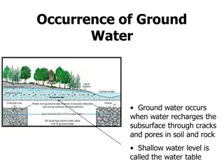
Hydrologic Cycle (Local view) Atmospheric Moisture Rain Snow Evaporation Interception Throughfall and Stem Flow Snowpack Snowmelt Watershed Boundary Pervious Impervious Surface Infiltration Our focus Evapotranspiration Soil Moisture Percolation Overland Flow Groundwater Groundwater Flow Evaporation Streams and Lakes Channel Flow Runoff 14
Water Budgets 1. Surface water budget P + Qin Qout + Qg ETs I = Ss 2. Groundwater budget I + Gin Gout - Qg ETg = Sg 3. System budget (1 + 2) P + Q + G ET = S 4. Net to groundwater G = S - P + Q + ET Q = (Qin Qout) = Net to Surface Water G = (Gin Gout) = Net to Groundwater 15
Major Aquifers of Texas Ogallala Edwards 16
Edwards Aquifer Primary geologic unit is Edwards Limestone One of the most permeable and productive aquifers in the U.S. The aquifer occurs in 3 distinct segments: Contributing zone Recharge zone Artesian zone 17
Contributing Zone of Edwards Aquifer Located north and west of the aquifer in the region referred to as the Edwards Plateau or Texas Hill Country Largest part of the aquifer spanning 4400 sq. miles Water in this region travels to recharge zone 18
Recharge Zone of Edwards Aquifer Geologically known as the Balcones fault zone It consists of an abundance of Edwards Limestone that is exposed at the surface -provides path for water to reach the artesian zone 19
Artesian Zone of Edwards Aquifer The artesian zone is a complex system of interconnected voids varying from microscopic pores to open caverns Located between two relatively less permeable layers that confine and pressurize the system Underlies 2100 square miles of land 20
The Ogallala Aquifer Approximately 170,000 wells draw water from the aquifer. Water level declines of 2-3 feet per year in some regions . Only 10% is restored by rainfall. 22
The Ogallala Aquifer Water-level Water Level Change up to 1980 Water Level Change 1980 - 1994 24
Summary Course Introduction and Housekeeping Groundwater and Aqufiers Terminology History Global Water Resources Global Water Cycle Texas Aquifers Edwards Ogallala 25


")


")


")