Understanding Runoff in Hydrology

 undefined

RUNOFF
LECTURE 10
1
RUNOFF
Runoff may be defined as that part of precipitation as well as any other flow
contributions which appear in surface streams of either perennial or seasonal nature.
It is the flow collected from a drainage basin appearing at the outlet of the basin or
catchment
The water which constitutes stream flow may reach the stream or channel by any of
the several routes from the point where it first reaches as precipitation
2
3
SOURCES OF RUNOFF
There are following sources of channel runoff
Precipitation that directly occurs on stream surface or river surface
Surface runoff/ overland flow
Interflow
Groundwater flow
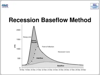
Direct Run Off
Base Flow
4
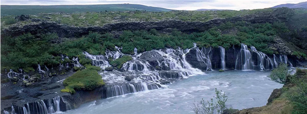
OVERLAND FLOW/ SURFACE RUNOFF
It is that water which travels over the ground surface to the channel
The channel may be any depression which may carry a rivulet of water
Such channels are numerous and the distance water must travel as surface runoff in
some cases is relatively short rarely more than hundred feet
Therefore surface runoff soon reaches a channel and if it occurs in sufficient quantity,
is an important parameter in forming the peak flood in the channel
The amount of surface runoff may be very small, since surface flow over a
permeable soil surface can only occur when the rainfall rate exceeds the local
infiltration capacity
5
OVERLAND FLOW/ SURFACE RUNOFF
In many small and moderate storms, surface runoff only occurs from impermeable
and saturated areas within the basin or from the precipitation that falls directly on
the stream surface
Except in urban areas, the extent of such areas is small part of the basin area
Hence surface runoff is the important part in stream flow only with very heavy or
high intensity storms
6
INTERFLOW
Some of the water that infiltrates soil surface may move laterally through the upper soil layers
until it enters a stream or a channel
This water is called interflow or subsurface storm flow
This water moves slower than the surface runoff and reaches the stream later
The proportion of total runoff that flows as interflow depends on the physical features of the
basin
A thin soil cover overlying a rock, hard pan or plowbed a short distance below the surface
favors substantial quantities of interflow
Whereas uniformly permeable encourages deeper percolation to ground water resulting in
less interflow
Although travelling very slow than overland flow, It may be huge in quantity especially in
storms of moderate intensity and hence may be a principle factor in the small rises in stream
7
GROUND WATER FLOW
Some precipitation percolates deep into the ground until it reaches the water table
The ground water accretion may eventually discharge into the streams as ground
water also called base flow or dry-weather flow if the water table intersects the
stream or channel
This contribution in streams doesn’t fluctuate rapidly because of its low velocity
Basins having highly permeable soils and large effluent ground water bodies show
sustained high flow throughout the year with a relatively small difference in mean
and flood flow
Basins having low permeable soils and large influent ground water bodies have
higher peak flow and average flow ratios
8
GROUND WATER FLOW
9
FACTORS AFFECTING SURFACE RUNOFF
There are to main categories of surface runoff
Related to precipitation characteristics
Related to physical characteristics of the basin
10
FACTORS AFFECTING SURFACE RUNOFF
Related to precipitation characteristics:
type of precipitation
Intensity of rainfall
Duration of rainfall
Distribution of storm intensity on basin area
Direction of storm movement
Other climatic conditions which affect evaporation and transpiration
11
FACTORS AFFECTING SURFACE RUNOFF
Related to physical characteristics of basin:
Land use
Type of soil
Area of water shed
Elevation of area
Lope of area
Orientation
Type of drainage network
12
ESTIMATION OF RUNOFF
Estimation of runoff is necessary for the following reasons
For determining the storage or yield available
For calculating inflow design floods
The runoff of a catchment can be computed daily, monthly or yearly as the need be
There are various methods of computations of runoff that can be classifies as follows:
Empirical formulae and tables
Infiltration method
Rational method
Unit hydrograph method
By estimating losses
13
EMPIRICAL FORMULAE AND TABLES
These formulae are derived considering the factors affecting
Surface runoff co-efficient method
Inglis formula
Lacey’s formula
Khosla formula
SCS Curve number method
Surface runoff co-efficient method
Runoff (cm) = co-efficient x rain fall (cm)
R = K.p
The value of co-efficient “K” depends upon the factors which affect the runoff
14
EMPIRICAL FORMULAE AND TABLES
15
EMPIRICAL FORMULAE AND TABLES
16
EMPIRICAL FORMULAE AND TABLES
R
m
= monthly runoff in cm must be
≥
0
P
m
= monthly rainfall in cm
L
m
= monthly Losses in cm
T
m
= mean monthly temperature in
o
C
17
NUMERICAL EXAMPLE
For a catchment the mean monthly rainfall and temperature are given. Calculate
annual runoff and runoff Co-efficient by khosla formula.
18
SCS CURVE NUMBER METHOD
The SCS Runoff Curve Number method is developed by the United States
Department of Agriculture (USDA) Soil Conservation Service (SCS) and is a method
of estimating rainfall excess from rainfall
The major disadvantages of the method are sensitivity of the method to Curve
Number (CN) values
The basis of the curve number method is the empirical relationship between the
retention (rainfall not converted into runoff) and runoff properties of the watershed
and the rainfall.
19
20
Soil Categories:
Category A:
Soil with very high infiltration
rates when wetted thoroughly
Category B:
Soils with moderate infiltration
rates when thoroughly wetted
Category C:
Soils with slow infiltration rates
when thoroughly wetted
Category D:
Soils with very slow infiltration
rates when thoroughly wetted
21
SCS CURVE NUMBER METHOD
Compute Surface runoff for a highly dense residential area with 65% impervious
area. The soil in area exposed to the precipitation is soil with slow infiltration rate.
Precipitation in the area is 9”.
22
BY APPLYING UNIT HYDROGRAPH METHOD
Hydrograph is a DRO hydrograph resulting due to unit effective precipitation (1cm/
1”) over the watershed
Area under unit hydrograph is always 1cm or 1” . It means volume of the
precipitation is normalized with watershed area
Unit hydrograph gives the time distribution of surface runoff due to unit effective
precipitation over the watershed
For any value of effective precipitation over the watershed, time distribution of the
surface runoff can be obtained by using ordinates of unit hydrograph
23
BY APPLYING UNIT HYDROGRAPH METHOD
24
BY APPLYING UNIT HYDROGRAPH METHOD
Procedure:
For the rainstorm compute effective precipitation
Peff= Pt – (E+I+T)
Compute time of concentration tc
Select duration of unit hydrograph
Pick the value of Qp from the unit hydrograph
Compute the Qp for given x(cm) precipitation
(Qp)x = x . (Qp)UHG
Time of concentration
: (t
c
)
it is the
time required by a drop of water
to reach at the outlet from the
farthest location of watershed
25
BY APPLYING UNIT HYDROGRAPH METHOD
Limitation:
Amount of rainfall is uniform over the whole watershed
Intensity of precipitation is uniform throughout the area
Applicable for smaller area
≤ 500 km
2
Method is applicable for tropical watersheds
26
RATIONAL FORMULA
Q
P
=Q = CIA
Runoff co-efficient depends upon surface conditions (0.05-0.95)
Assumptions:
Rainfall is uniform throughout the area
Intensity used is average intensity of storm
27
Runoff in hydrology refers to surface water flow from precipitation and other sources in drainage basins. It plays a crucial role in stream flow and peak flood formation, influenced by factors like overland flow, interflow, and groundwater flow. This article explores the sources of runoff, including surface runoff and base flow, and explains how different types of runoff contribute to stream flow dynamics.

Download Presentation

Please find below an Image/Link to download the presentation.
The content on the website is provided AS IS for your information and personal use only. It may not be sold, licensed, or shared on other websites without obtaining consent from the author. Download presentation by click this link. If you encounter any issues during the download, it is possible that the publisher has removed the file from their server.
E N D
Presentation Transcript
RUNOFF LECTURE 10 1
RUNOFF Runoff may be defined as that part of precipitation as well as any other flow contributions which appear in surface streams of either perennial or seasonal nature. It is the flow collected from a drainage basin appearing at the outlet of the basin or catchment The water which constitutes stream flow may reach the stream or channel by any of the several routes from the point where it first reaches as precipitation 2
SOURCES OF RUNOFF There are following sources of channel runoff Precipitation that directly occurs on stream surface or river surface Surface runoff/ overland flow Interflow Groundwater flow Base Flow Direct Run Off 4
OVERLAND FLOW/ SURFACE RUNOFF It is that water which travels over the ground surface to the channel The channel may be any depression which may carry a rivulet of water Such channels are numerous and the distance water must travel as surface runoff in some cases is relatively short rarely more than hundred feet Therefore surface runoff soon reaches a channel and if it occurs in sufficient quantity, is an important parameter in forming the peak flood in the channel The amount of surface runoff may be very small, since surface flow over a permeable soil surface can only occur when the rainfall rate exceeds the local infiltration capacity 5
OVERLAND FLOW/ SURFACE RUNOFF In many small and moderate storms, surface runoff only occurs from impermeable and saturated areas within the basin or from the precipitation that falls directly on the stream surface Except in urban areas, the extent of such areas is small part of the basin area Hence surface runoff is the important part in stream flow only with very heavy or high intensity storms 6
INTERFLOW Some of the water that infiltrates soil surface may move laterally through the upper soil layers until it enters a stream or a channel This water is called interflow or subsurface storm flow This water moves slower than the surface runoff and reaches the stream later The proportion of total runoff that flows as interflow depends on the physical features of the basin A thin soil cover overlying a rock, hard pan or plowbed a short distance below the surface favors substantial quantities of interflow Whereas uniformly permeable encourages deeper percolation to ground water resulting in less interflow Although travelling very slow than overland flow, It may be huge in quantity especially in storms of moderate intensity and hence may be a principle factor in the small rises in stream 7
GROUND WATER FLOW Some precipitation percolates deep into the ground until it reaches the water table The ground water accretion may eventually discharge into the streams as ground water also called base flow or dry-weather flow if the water table intersects the stream or channel This contribution in streams doesn t fluctuate rapidly because of its low velocity Basins having highly permeable soils and large effluent ground water bodies show sustained high flow throughout the year with a relatively small difference in mean and flood flow Basins having low permeable soils and large influent ground water bodies have higher peak flow and average flow ratios 8
FACTORS AFFECTING SURFACE RUNOFF There are to main categories of surface runoff Related to precipitation characteristics Related to physical characteristics of the basin 10
FACTORS AFFECTING SURFACE RUNOFF Related to precipitation characteristics: type of precipitation Intensity of rainfall Duration of rainfall Distribution of storm intensity on basin area Direction of storm movement Other climatic conditions which affect evaporation and transpiration 11
FACTORS AFFECTING SURFACE RUNOFF Related to physical characteristics of basin: Land use Type of soil Area of water shed Elevation of area Lope of area Orientation Type of drainage network 12
ESTIMATION OF RUNOFF Estimation of runoff is necessary for the following reasons For determining the storage or yield available For calculating inflow design floods The runoff of a catchment can be computed daily, monthly or yearly as the need be There are various methods of computations of runoff that can be classifies as follows: Empirical formulae and tables Infiltration method Rational method Unit hydrograph method By estimating losses 13
EMPIRICAL FORMULAE AND TABLES These formulae are derived considering the factors affecting Surface runoff co-efficient method Inglis formula Lacey s formula Khosla formula SCS Curve number method Surface runoff co-efficient method Runoff (cm) = co-efficient x rain fall (cm) R = K.p The value of co-efficient K depends upon the factors which affect the runoff 14
EMPIRICAL FORMULAE AND TABLES Inglis Formula (Bombay-Deccan catchment) ? =(? 17.8)? ? P and R are in cm 254 Numerical example: Determine runoff in cm when precipitation over a watershed area is 23cm. 15
EMPIRICAL FORMULAE AND TABLES Lacey s Formula (Gangetic Plain) ? ? = 1+304.8 (? ?) ? R & P are in cm P= mean annual precipitation F= precipitation durability factor for example for full monsoon (F=1.5) and for a complete failure of monsoon (0.5) S= catchment factor depending upon the slope and varies from 0.25 for flat regions to 3.45 for hilly areas Numerical example: Determine runoff in cm when mean annual precipitation over a watershed area is 98cm. You may assume a full monsoon and flat region. 16
EMPIRICAL FORMULAE AND TABLES Khosla Formula (Gangetic Plain) In this method, the amount of mean annual runoff is calculated by following formula: ? ? = ? 3.74 R & P are in cm T is temperature in oC A rational form of khosla formula is based on the concept that the losses are only by evaporation and transpiration and the water that infiltrates ultimately finds its way into the stream Rm = Pm Lm Lm = 0.48 Tm (For Tm >4.5oC) use tables for (Tm 4.5oC) Annual Runoff= ?? Rm = monthly runoff in cm must be 0 Pm = monthly rainfall in cm Lm = monthly Losses in cm Tm = mean monthly temperature in oC 17
NUMERICAL EXAMPLE For a catchment the mean monthly rainfall and temperature are given. Calculate annual runoff and runoff Co-efficient by khosla formula. Temperature (oC) Month Temperature (oC) Month Rainfall (cm) Rainfall (cm) Jan 12 4 July 31 32 Feb 16 4 August 29 29 March 21 2 Sept 28 16 April 27 0 Oct 29 2 May 31 2 Nov 19 1 June 34 12 Dec 14 2 18
SCS CURVE NUMBER METHOD The SCS Runoff Curve Number method is developed by the United States Department of Agriculture (USDA) Soil Conservation Service (SCS) and is a method of estimating rainfall excess from rainfall The major disadvantages of the method are sensitivity of the method to Curve Number (CN) values The basis of the curve number method is the empirical relationship between the retention (rainfall not converted into runoff) and runoff properties of the watershed and the rainfall. 19
Soil Categories: Category A: Soil with very high infiltration rates when wetted thoroughly Category B: Soils with moderate infiltration rates when thoroughly wetted Category C: Soils with slow infiltration rates when thoroughly wetted Category D: Soils with very slow infiltration rates when thoroughly wetted 21
SCS CURVE NUMBER METHOD Compute Surface runoff for a highly dense residential area with 65% impervious area. The soil in area exposed to the precipitation is soil with slow infiltration rate. Precipitation in the area is 9 . 22
BY APPLYING UNIT HYDROGRAPH METHOD Hydrograph is a DRO hydrograph resulting due to unit effective precipitation (1cm/ 1 ) over the watershed Area under unit hydrograph is always 1cm or 1 . It means volume of the precipitation is normalized with watershed area Unit hydrograph gives the time distribution of surface runoff due to unit effective precipitation over the watershed For any value of effective precipitation over the watershed, time distribution of the surface runoff can be obtained by using ordinates of unit hydrograph 23
BY APPLYING UNIT HYDROGRAPH METHOD Procedure: For the rainstorm compute effective precipitation Peff= Pt (E+I+T) Compute time of concentration tc Select duration of unit hydrograph Pick the value of Qp from the unit hydrograph Compute the Qp for given x(cm) precipitation Time of concentration: (tc) it is the time required by a drop of water to reach at the outlet from the farthest location of watershed (Qp)x = x . (Qp)UHG 25
BY APPLYING UNIT HYDROGRAPH METHOD Limitation: Amount of rainfall is uniform over the whole watershed Intensity of precipitation is uniform throughout the area Applicable for smaller area 500 km2 Method is applicable for tropical watersheds 26
RATIONAL FORMULA Runoff Coefficient Peak discharge QP =Q = CIA Area of watershed Rainfall intensity Runoff co-efficient depends upon surface conditions (0.05-0.95) Assumptions: Rainfall is uniform throughout the area Intensity used is average intensity of storm 27