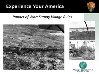
Orote Field in World War II: Battles and Remnants
Orote Field played a significant role in the World War II battles between the Japanese and Americans on Guam. The Japanese occupied Guam from December 1941 to July 1944, constructing Orote Field using Korean and Guamanian labor. American raids in 1944 destroyed the field, leading to intense anti-aircraft fire. After an invasion in July 1944, the 1st Provincial Marine Brigade fought through Agat village to the base of Orote Peninsula, overcoming Japanese resistance. The area had elaborate defenses, and American forces eventually took control. Numerous aerial actions occurred around Orote Field between American and Japanese aircraft. Explore the remnants and history of this strategic location.

Download Presentation

Please find below an Image/Link to download the presentation.
The content on the website is provided AS IS for your information and personal use only. It may not be sold, licensed, or shared on other websites without obtaining consent from the author.If you encounter any issues during the download, it is possible that the publisher has removed the file from their server.
You are allowed to download the files provided on this website for personal or commercial use, subject to the condition that they are used lawfully. All files are the property of their respective owners.
The content on the website is provided AS IS for your information and personal use only. It may not be sold, licensed, or shared on other websites without obtaining consent from the author.
E N D
Presentation Transcript
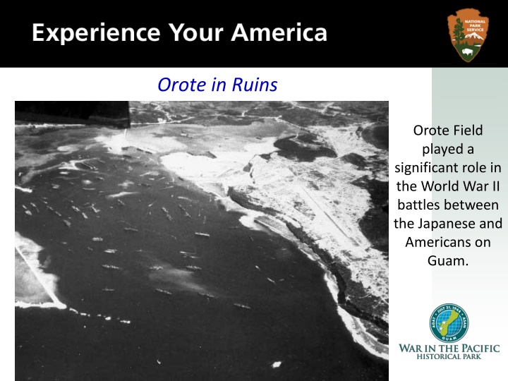
Orote in Ruins Orote Field played a significant role in the World War II battles between the Japanese and Americans on Guam.
The Japanese occupied Guam from December 13, 1941 to July 9, 1944. This is an aerial view of the Orote airfield on the Orote Peninsula and Apra Harbor During that time, the Japanese military government constructed Orote Field, a land-based airfield, using Korean and Guamanian labor.
On February 23, 1944, American carrier based airplanes attacked the field, and other American raids soon followed. This is an aerial view of Orote Peninsula. August 7, 1944. During the Battle of the Philippine Sea against the Americans, the field was used by the Japanese carrier-based airplanes to refuel and rearm.
American raids on June 19, 1944 destroyed the landing fields, the aircraft on the ground and such aircraft that managed to take off. American pilots reported extremely intense anti- aircraft fire around Orote Field. This is an aerial view, altitude about 1,000 feet of the end of Orote Peninsula airfield and town of Sumay. July 22, 1944. Fifteen Japanese airplanes crashed while attempting to land on Orote Field that day.
After the invasion on July 21, 1944, the 1st Provincial Marine Brigade, under command of Lt. General Lemuel C. Shepherd, fought its way through the village of Agat to the base of Orote Peninsula. This is Orote Peninsula where Marines have just finished cleaning out Japanese resistance. July 31, 1944.
In Agat, the Japanese had constructed an elaborate interlocking system of pillboxes, strongpoints and trenches. Regiments of the 1st Provisional Marine Brigade, the 4th and 22nd, fought their way through the area. Marines and field pieces, pulled by trucks, move across the airfield as they took it over from the Japanese. July 1944.
On June 20, 1944, numerous actions occurred in the immediate vicinity of Orote Field between American carrier airplanes and Japanese aircrafts seeking refuge at Orote Field after flying from their carriers. Japanese planes destroyed on the ground by gunfire next to Orote peninsula. July 1944.
Numerous dogfights took place in the air above Orote Field and numerous strikes by American airplanes destroyed Japanese facilities and airplanes on the ground. This was significant because it denied the Japanese the use of a crucial airfield in the battle. This is a Japanese tank forced out of action on Orote.
Shortly before midnight on July 26, 1944, the Japanese trapped on the peninsula staged a suicide attack and were completely wiped out. The advancing Marines still met heavy Japanese resistance in the vicinity of the airfield, where the Japanese fought from caves and coconut bunkers. Aerial view of the Japanese air field on the Orote Peninsula. August 7, 1944.
The peninsula was declared secure on July 29, 1944. It is estimated that the Japanese lost more than 3,000 men defending Orote Peninsula. Orote Peninsula airfield, AC- 47 at left of center. August 10, 1944.
Orote Field was used by Marine air power for close combat support missions during the liberation of Guam. This was accomplished by Marine Air Group (MAG-21) flying Corsairs from Orote Field. This photo is of the taxiway on the Orote Peninsula Airfield. October 5, 1944.
Analyzing Photographs & Prints 1) Observe 2) Reflect Identify and note details. Ask yourself the following questions: What did I notice first? What people and objects are shown? How are they arranged? What is the physical setting? What, if any, words do I see? What other details can I see? Generate and test hypotheses about the image. Why do you think this image was made? What s happening in the image? When do you think it was made? Who do you think was the audience for this image? What tools were used to create this? What can you learn from examining this image? What s missing from this image? If someone made this today, what would be different? What would be the same?
Write a caption for each of the following images that you see. OR Predict what will happen one minute after the scene shown in the following images. Now Let s Analyze!
Here Marines examine a wrecked Japanese plane at Orote. The plane was one of many damaged beyond repair by aerial bombings and naval shelling.
The Japanese airfield on Orote Peninsula was one of the prime objectives of assaulting Marines. August 1944.
Analyzing Photographs & Prints 3) Further Investigation Ask questions to lead to more observations and reflections about these photos. What do you wonder about Who? What? When? Where? Why? How? information and understanding of World War II. How would you refine or revise the way history could be taught in schools? How would you expand or alter your textbook explanations of history based on these primary sources you just looked at? Consider how these photos support or challenge
Bibliography War in the Pacific National Historical Park. Orote. nps.gov. National Park Service, n.d. Web. 2 March 2011.