Impact of War: Sumay Village Ruins
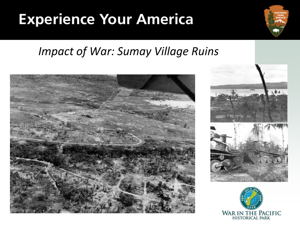
Impact of War: Sumay Village Ruins
Sumay was originally a small prehistoric Chamorro village
located on the southern edge of Apra harbor.
Ruins of a Japanese
Marine Barracks. July 31,
1944.
The harbor was a natural deep water port long before the building
of the Glass Breakwater, and as such attracted ships from Asia,
England, France, Germany, Holland, Russia, Spain, and the United
States for many hundreds of years.
Aerial view of
Sumay on Orote
peninsula and
Cabras Island in
the background.
August 7, 1944
During the 17th, 18th,
and 19th centuries
Spanish ships regularly
came to Sumay. In the
1820’s, whalers pulled
into Sumay to replenish
their supplies, and to
take a break from the
sea for a few days. The
port of Sumay is found
on the earliest maps of
the island of Guam.
In 1904, the Transpacific Telephone Cable was laid from
Hawaii to Guam, and on to Manila, Hong Kong, Shanghai,
and Yap island. The Cable station, which brought the first
telephone service to Guam, was located in Sumay.
Then in 1921, the U.S. Marine
Aviation Squadron and Marine
Barracks were established in Sumay.
Pan American Airways located their
Air Operations Building in Sumay in
1935, and it was there that the China
Clipper landed on the way from
California to Manila, and points east.
Orote Peninsula. August 8, 1944.
Two thousand people lived in Sumay in 1941.
Ruins of
Sumay.
Apra
Harbor.
August 1,
1944.
Due to the strategic location of the village of Sumay, that was the first
site of Japanese bombing on the island of Guam, December 8th, 1941.
Analyzing Photographs & Prints
1) Observe
•
Identify and note details.
•
Ask yourself the following
questions:
–
What did I notice first?
–
What people and objects are
shown?
–
How are they arranged?
–
What is the physical setting?
–
What, if any, words do I see?
–
What other details can I see?
2) Reflect
•
Generate and test hypotheses
about the image.
–
Why do you think this image was made?
–
What’s happening in the image?
–
When do you think it was made?
–
Who do you think was the audience for this
image?
–
What tools were used to create this?
–
What can you learn from examining this
image?
–
What’s missing from this image?
–
If someone made this today, what would be
different? What would be the same?
Now Let’s Analyze!
•
Write a caption for
each of the following
images that you see.
OR
•
Predict what will
happen one minute
after the scene shown
in the following
images.
Japanese Tanks found on the road to Sumay. July 1944.
Wreckage of Sumay. August 7, 1944.
Sumay is converted by the U.S. military to an unloading
depot for marine aviation supplies. August 1944.
3) Further Investigation
•
Ask questions to lead to more observations and reflections about these
photos.
•
What do you wonder about…
–
Who?
–
What?
–
When?
–
Where?
–
Why?
–
How?
Analyzing Photographs & Prints
•
How would you expand or alter your textbook
explanations of history based on these primary sources
you just looked at?
•
Consider
how these photos support or challenge
information and understanding of World War II. How
would you refine or revise the way history could be taught
in schools?
Bibliography
War in the Pacific National Historical
Park.
Sumay Village
.
nps.gov
. National
Park Service, n.d. Web. March 2011.
Five-State Govenment Documents Conference
August 2006
Left Photo: Aerial view of the ruins of the town of Sumay on the Orote Peninsula. The end of the runway at the Japanese airfield is in the upper right. August 8, 1944. (National Archives 80-G-239718).
Sumay Village, a historic Chamorro settlement located in Apra Harbor on the island of Guam, was a hub for international ships and telecommunications before being heavily impacted by war. The village saw Japanese bombings in 1941 and was left in ruins by the military actions during World War II. The images showcase the remnants of Sumay and its strategic significance in history.

Download Presentation

Please find below an Image/Link to download the presentation.
The content on the website is provided AS IS for your information and personal use only. It may not be sold, licensed, or shared on other websites without obtaining consent from the author.If you encounter any issues during the download, it is possible that the publisher has removed the file from their server.
You are allowed to download the files provided on this website for personal or commercial use, subject to the condition that they are used lawfully. All files are the property of their respective owners.
The content on the website is provided AS IS for your information and personal use only. It may not be sold, licensed, or shared on other websites without obtaining consent from the author.
E N D
Presentation Transcript
Sumay was originally a small prehistoric Chamorro village located on the southern edge of Apra harbor. Ruins of a Japanese Marine Barracks. July 31, 1944.
The harbor was a natural deep water port long before the building of the Glass Breakwater, and as such attracted ships from Asia, England, France, Germany, Holland, Russia, Spain, and the United States for many hundreds of years. During the 17th, 18th, and 19th centuries Spanish ships regularly came to Sumay. In the 1820 s, whalers pulled into Sumay to replenish their supplies, and to take a break from the sea for a few days. The port of Sumay is found on the earliest maps of the island of Guam. Aerial view of Sumay on Orote peninsula and Cabras Island in the background. August 7, 1944
In 1904, the Transpacific Telephone Cable was laid from Hawaii to Guam, and on to Manila, Hong Kong, Shanghai, and Yap island. The Cable station, which brought the first telephone service to Guam, was located in Sumay. Then in 1921, the U.S. Marine Aviation Squadron and Marine Barracks were established in Sumay. Pan American Airways located their Air Operations Building in Sumay in 1935, and it was there that the China Clipper landed on the way from California to Manila, and points east. Orote Peninsula. August 8, 1944.
Two thousand people lived in Sumay in 1941. Ruins of Sumay. Apra Harbor. August 1, 1944. Due to the strategic location of the village of Sumay, that was the first site of Japanese bombing on the island of Guam, December 8th, 1941.
Analyzing Photographs & Prints 1) Observe 2) Reflect Identify and note details. Ask yourself the following questions: What did I notice first? What people and objects are shown? How are they arranged? What is the physical setting? What, if any, words do I see? What other details can I see? Generate and test hypotheses about the image. Why do you think this image was made? What s happening in the image? When do you think it was made? Who do you think was the audience for this image? What tools were used to create this? What can you learn from examining this image? What s missing from this image? If someone made this today, what would be different? What would be the same?
Write a caption for each of the following images that you see. OR Predict what will happen one minute after the scene shown in the following images. Now Let s Analyze!
Sumay is converted by the U.S. military to an unloading depot for marine aviation supplies. August 1944.
Analyzing Photographs & Prints 3) Further Investigation Ask questions to lead to more observations and reflections about these photos. What do you wonder about Who? What? When? Where? Why? How? information and understanding of World War II. How would you refine or revise the way history could be taught in schools? How would you expand or alter your textbook explanations of history based on these primary sources you just looked at? Consider how these photos support or challenge
Bibliography War in the Pacific National Historical Park. Sumay Village. nps.gov. National Park Service, n.d. Web. March 2011.


![[PDF⚡READ❤ONLINE] In Ruins: A Journey Through History, Art, and Literature](/thumb/20543/pdf-read-online-in-ruins-a-journey-through-history-art-and-literature.jpg)