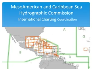
Hydrographic Commission on Antarctica - Survey and Charting Progress


IHO Hydrographic Commission on Antarctica (HCA)
HCA-15, Niteroi, Brazil, 26 – 28 June 2018
National Report by
Japan


Survey and charting progress in Antarctica since HCA-14
(June 2016)
HCA-15, Niteroi, Brazil, 26 – 28 June 2018
•
New charts produced (INT, national, ENC)
•
Areas Surveyed
•
Data Provision
New charts produced (ENC)
June 2016
“Approach” ENCs based on INT9047, Cell size
:
30
´
Cell No.
:
JP40P0TS, Area
:
69-30S - 69-00S 39-00E - 39-30E
Cell No.
:
JP40P0TU, Area
:
69-30S - 69-00S 39-30E - 40-00E
Cell No.
:
JP40PKES, Area
:
69-00S - 68-30S 39-00E - 39-30E
Cell No.
:
JP40PKEU, Area
:
69-00S - 68-30S 39-30E - 40-00E
Aug 2016
“General Navigation” ENCs based on INT9045 , Cell size
:
4
°
Cell No.
:
JP20ODCG, Area
:
70-00S - 66-00S 36-00E - 40-00E
“Coastal Navigation” ENCs based on INT9046 , Cell size
:
1
°
Cell No.
:
JP30ODCO, Area
:
70-00S - 69-00S 38-00E - 39-00E
Cell No.
:
JP30ODCS, Area
:
70-00S - 69-00S 39-00E - 40-00E
Cell No.
:
JP30PKEO, Area
:
69-00S - 68-00S 38-00E - 39-00E
Cell No.
:
JP30PKES, Area
:
69-00S - 68-00S 39-00E - 40-00E
“Harbour” ENCs based on INT9047 Plan , Cell size
:
15
´
Cell No.
:
JP50PAME, Area 69-15S - 69-00S 39-30E - 39-45E
Cell No.
:
JP50PKEU, Area 69-00S - 68-45S 39-30E - 39-45E
HCA-15, Niteroi, Brazil, 26 – 28 June 2018
New charts produced (INT and national paper charts)
July 2016
INT9046 (published as national paper charts “W3941”)
Title ONGUL ISLANDS TO SKARVSNES
Area
:
68-52S, 69-28S, 38-47E and 39-55E Scale 1:100,000
HCA-15, Niteroi, Brazil, 26 – 28 June 2018
Areas Surveyed
Due to damage of multibeam sonar of Japanese
icebreaker “Shirase”, Japan has not been able to conduct
hydrographic surveys in Antarctic region since 2014.
JHOD has made efforts to ensure budget to repair the
multibeam sonar in cooperation with the ministry* which
is in charge of Antarctic projects.
*
Ministry of Education, Culture, Sports, Science and Technology
The multibeam sonar would be repaired in 2019
hopefully.
HCA-15, Niteroi, Brazil, 26 – 28 June 2018
Planned Activities 2018-19
HCA-15, Niteroi, Brazil, 26 – 28 June 2018
•
new charts
No plans at this
stage
•
new surveys
No plans in 2018
Red rectangles in
the right figure
during
Dec. 2019-
Mar. 2020.
:
Planned survey
(Dec. 2019-Mar. 2020)
Lützow-holm bay
32 deg E
56 deg E
70 deg S
64 deg S
Data provision
•
Japan has developed online system to provide oceanographic and
bathymetric data.
http://www.jodc.go.jp/jodcweb/JDOSS/index.html
HCA-15, Niteroi, Brazil, 26 – 28 June 2018
•
Marine data such as bathymetry, tide,
salinity, DO and temperature in
Antarctica can be downloaded.
--- >
The data will also contribute to
GEBCO Seabed2030.
Bathymetry
http://jdoss1.jodc.go.jp/vpage2017/JAREdepth.html
Tide at “Showa” station of Japan
http://jdoss1.jodc.go.jp/vpage/tide.html
Salinity, DO and Temperature
http://jdoss1.jodc.go.jp/vpage/scalar.html
Report on survey and charting progress in Antarctica, including new charts produced since HCA-14 in June 2016. Covers areas surveyed, data provision, and planned activities for 2018-2019.

Download Presentation

Please find below an Image/Link to download the presentation.
The content on the website is provided AS IS for your information and personal use only. It may not be sold, licensed, or shared on other websites without obtaining consent from the author. Download presentation by click this link. If you encounter any issues during the download, it is possible that the publisher has removed the file from their server.
E N D
Presentation Transcript
IHO Hydrographic Commission on Antarctica (HCA) National Report by Japan International Hydrographic Organization Organisation Hydrographique Internationale HCA-15, Niteroi, Brazil, 26 28 June 2018
Survey and charting progress in Antarctica since HCA-14 (June 2016) New charts produced (INT, national, ENC) Areas Surveyed Data Provision International Hydrographic Organization Organisation Hydrographique Internationale HCA-15, Niteroi, Brazil, 26 28 June 2018
New charts produced (ENC) June 2016 Approach ENCs based on INT9047, Cell size 30 Cell No. JP40P0TS, Area 69-30S - 69-00S 39-00E - 39-30E Cell No. JP40P0TU, Area 69-30S - 69-00S 39-30E - 40-00E Cell No. JP40PKES, Area 69-00S - 68-30S 39-00E - 39-30E Cell No. JP40PKEU, Area 69-00S - 68-30S 39-30E - 40-00E Aug 2016 General Navigation ENCs based on INT9045 , Cell size 4 Cell No. JP20ODCG, Area 70-00S - 66-00S 36-00E - 40-00E Coastal Navigation ENCs based on INT9046 , Cell size 1 Cell No. JP30ODCO, Area 70-00S - 69-00S 38-00E - 39-00E Cell No. JP30ODCS, Area 70-00S - 69-00S 39-00E - 40-00E Cell No. JP30PKEO, Area 69-00S - 68-00S 38-00E - 39-00E Cell No. JP30PKES, Area 69-00S - 68-00S 39-00E - 40-00E Harbour ENCs based on INT9047 Plan , Cell size 15 Cell No. JP50PAME, Area 69-15S - 69-00S 39-30E - 39-45E Cell No. JP50PKEU, Area 69-00S - 68-45S 39-30E - 39-45E International Hydrographic Organization Organisation Hydrographique Internationale HCA-15, Niteroi, Brazil, 26 28 June 2018
New charts produced (INT and national paper charts) July 2016 INT9046 (published as national paper charts W3941 ) Title ONGUL ISLANDS TO SKARVSNES Area 68-52S, 69-28S, 38-47E and 39-55E Scale 1:100,000 International Hydrographic Organization Organisation Hydrographique Internationale HCA-15, Niteroi, Brazil, 26 28 June 2018
Areas Surveyed Due to damage of multibeam sonar of Japanese icebreaker Shirase , Japan has not been able to conduct hydrographic surveys in Antarctic region since 2014. JHOD has made efforts to ensure budget to repair the multibeam sonar in cooperation with the ministry* which is in charge of Antarctic projects. *Ministry of Education, Culture, Sports, Science and Technology The multibeam sonar would be repaired in 2019 hopefully. International Hydrographic Organization Organisation Hydrographique Internationale HCA-15, Niteroi, Brazil, 26 28 June 2018
Planned Activities 2018-19 new charts No plans at this stage new surveys No plans in 2018 Red rectangles in the right figure during Dec. 2019- Mar. 2020. 64 deg S L tzow-holm bay Planned survey (Dec. 2019-Mar. 2020) 70 deg S 32 deg E 56 deg E International Hydrographic Organization Organisation Hydrographique Internationale HCA-15, Niteroi, Brazil, 26 28 June 2018
Data provision Japan has developed online system to provide oceanographic and bathymetric data. http://www.jodc.go.jp/jodcweb/JDOSS/index.html Marine data such as bathymetry, tide, salinity, DO and temperature in Antarctica can be downloaded. --- > The data will also contribute to GEBCO Seabed2030. Bathymetry http://jdoss1.jodc.go.jp/vpage2017/JAREdepth.html Tide at Showa station of Japan http://jdoss1.jodc.go.jp/vpage/tide.html Salinity, DO and Temperature http://jdoss1.jodc.go.jp/vpage/scalar.html International Hydrographic Organization Organisation Hydrographique Internationale HCA-15, Niteroi, Brazil, 26 28 June 2018
")

")
")