
Overview of Physical Geography and Resources in Latin America
Latin America spans 7,000 miles from the U.S.-Mexico border to Tierra del Fuego and includes diverse geographic features such as the Andes Mountains, grassy plains like Llanos and Pampas, and major river systems like the Orinoco and Amazon. The region is rich in natural resources including mineral d
7 views • 21 slides
Geography of Europe: Features and Significance
Delve into the geographic features of Europe through maps and explanations, understanding the importance of locations such as rivers, seas, and mountains. Discover the impact of geography on economy, culture, and development, while learning about terms like peninsulas, plains, plateaus, straits, and
2 views • 27 slides
Georgia's Diverse Geography and Physical Features
Georgia's geography is characterized by its unique physical features, including mountains to the north and the largest swamp in North America to the south. This state boasts a varied landscape comprising five distinct geographic regions: Blue Ridge Mountains, Valley and Ridge, Appalachian Plateau, P
0 views • 50 slides
Georgia Studies Test Prep Essentials for 8th Grade
Explore Georgia's physical features and regions, such as the Blue Ridge Mountains and Coastal Plain. Learn about the economic opportunities each region offers, the impact of climate on Georgia's development, and historical significance. Test your knowledge with questions on geographic regions and th
1 views • 65 slides

Evolution of Data Processing Systems in Geographic Information Science
Data processing systems in Geographic Information Science have evolved from manual, analogue methods to advanced software and hardware components. The incorporation of Geographic Information Systems (GIS) has revolutionized the handling and analysis of geo-referenced data, making tasks like data cap
3 views • 20 slides
Geographic Objects in GIS
Geographic objects play a crucial role in GIS by being easily distinguished and named based on parameters like location, shape, size, and orientation. These objects are studied collectively to understand their interactions and relationships, aiding in tasks such as navigation systems and route optim
5 views • 13 slides

Geographic Information System in Sud Nouvelle Calédonie
The province of Sud Nouvelle Calédonie utilizes an open-source-based Geographic Information System (GIS) to serve its territorial administration, with a focus on applications such as land administration, environment, agriculture, and urban planning. The system is supported by a team of engineers, g
0 views • 15 slides

2nd Grade National Geographic: Weather, Tools, and Natural Disasters
Dive into the fascinating world of weather phenomena with 2nd-grade National Geographic resources. From predicting weather using clouds to learning about thunderstorms, hurricanes, and tornadoes, this educational journey also covers weather tools and being prepared for natural disasters.
0 views • 15 slides
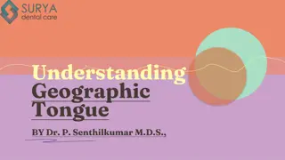
what is Geographic Tongue and how does it look
Geographical tongue is an non-contagious condition that provides an atypical, map-like structure to the tongue. A detailed note on this problem is given here. For More Info Visit: \/\/ \/what-is-geographic-tongue\/
0 views • 11 slides

what is Geographic Tongue and how does it look
Geographical tongue is an non-contagious condition that provides an atypical, map-like structure to the tongue. A detailed note on this problem is given here. For More Info Visit: \/\/ \/what-is-geographic-tongue\/
0 views • 11 slides
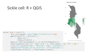
Geographic Data Visualization in R and QGIS for Malawi Health Analysis
Utilizing R and QGIS, this project focuses on visualizing sickle cell and HIV percentages by district in Malawi, mapping health facility locations, creating Voronoi polygons, and displaying malaria cumulative incidence data. Various geographic data visualization techniques are applied to provide ins
0 views • 8 slides

Feature Engineering in Machine Learning
Feature engineering involves transforming raw data into meaningful features to improve the performance of machine learning models. This process includes selecting, iterating, and improving features, converting context to input for learning algorithms, and balancing the complexity of features, concep
1 views • 28 slides
Integrating Geographic Data with BI Dashboards for Strategic Insights
Explore the transformative potential of integrating geographic data into BI dashboard tool for strategic insights in our latest blog. Dive deep into the process\u2014from defining precise objectives and meticulous data collection to expert dashboard
0 views • 13 slides
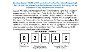
Geographic Distribution Using 3-Digit ZIP Codes
Massachusetts has approximately 685 5-digit ZIP codes assigned by the USPS, which can be aggregated into 18 3-digit ZIP codes for geographic analysis. The distribution of Emergency Department visit volumes varies across these 3-digit ZIP code boundaries, reflecting different regional characteristics
1 views • 4 slides

Discover Sri Lanka: Culture, People, and Geography
Dive into the diverse world of Sri Lanka, exploring its rich culture, ethnic groups, and unique geographic features. Learn about the nicknames of Sri Lanka, its distinctive shape on the map, and the warm greetings of its people. Uncover the history and traditions that make Sri Lanka the Pearl of the
0 views • 33 slides

Industrial Potentials of Zabljak Municipality: A Overview of Resources and Opportunities
Zabljak, a municipality in northwestern Montenegro, boasts vast industrial potentials in forestry, wood processing, mineral resources, and more. With rich natural resources such as forests and minerals, Zabljak presents opportunities for economic development, particularly in the tourism sector. The
0 views • 18 slides
GAC Working Group on Geographic Names Protection in New gTLD Expansion
The GAC Working Group is focused on improving protections for geographic names in future gTLD expansions. They aim to develop practical options and rules to reduce uncertainties for governments, communities, and applicants using geographic or community names. The group seeks to engage local communit
3 views • 27 slides
Exposing the Myth of Misinformation Through Geography and GIS
Geography and Geographic Information Systems play a crucial role in debunking the myths of misinformation. Dr. Barry Wellar discusses the impact of misinformation, highlighting the importance of geographic data in transforming information and knowledge. The presentation delves into the reasons behin
0 views • 17 slides

Mrs. Carter's Social Studies Class Agenda - February 24-28, 2020
Explore Canada's assessment standards and Australia's geographic features in Mrs. Carter's social studies class agenda for the week of February 24-28, 2020. Topics include NAFTA, Australia's landmarks, climate study, and more. Engage in activities, tests, and projects related to global geography and
0 views • 9 slides

Tongue Disorders: Ankyloglossia, Black Hairy Tongue, Geographic Tongue
Ankyloglossia, also known as tongue-tied, is a congenital anomaly affecting tongue mobility. Black hairy tongue is the lengthening of papillae on the tongue surface, often temporary and resolve without treatment. Geographic tongue presents as white patches and is usually asymptomatic. Treatment opti
0 views • 10 slides
Business Process Management Conference 2014 Program Highlights
The BPM 2014 conference program features keynotes on Cognitive Computing and learning organizations, along with paper sessions covering various topics such as User Centered Process Approaches, Process Analytics, and Declarative Processes. The event includes tutorials, demos, submission statistics, g
0 views • 7 slides
Geographic Information Systems: GIS in Statistics and INSPIRE Reporting Obligations
This document outlines the agenda and practical details for a GIS workshop focusing on statistical production and data processing related to geographic information systems. It includes sessions on population gridded data production, automation processes, and practical exercises. Participants from va
2 views • 5 slides
Geographic Data Analysis in Health Statistics Conference
The 2010 National Conference on Health Statistics explored the use of restricted data at the National Center for Health Statistics Research Data Center. The presentation delved into the types of data requested, including small geographic areas, sensitive information, mortality files, and genetic dat
0 views • 45 slides
Open Data Interface (ODI) Project Overview and Components
Open Data Interface (ODI) is a database system developed in 2008 for ingesting, processing, storing, and retrieving space environment data. The project involves a server, client, and various components for data manipulation and integration. Current contractors include DH Consultancy and Solar Analyt
0 views • 15 slides
Impact of Geography and Religion on African Society
African society was heavily influenced by geographic features such as diverse climates, terrains, and the Bantu migrations, which spread language, technology, and farming techniques. Additionally, religion, specifically animism, shaped beliefs and practices. The question posed at the end challenges
0 views • 8 slides
Overview of the U.S. Federal Statistical System and Census Geography
The U.S. Federal Statistical System comprises 13 principal statistical agencies responsible for collecting and analyzing data across various sectors. The system includes agencies like the Bureau of Economic Analysis, Bureau of Labor Statistics, and U.S. Census Bureau. Geographic identifiers (GEOIDs
0 views • 94 slides

Geographic Concepts Explained with Visuals
Explore various geographic concepts such as time zones, latitude, albedo, environmental spheres, and interactions between spheres through informative images and descriptions. Topics include longitude measurements, Tropic of Cancer location, hemispheres identification, time zone differences, environm
0 views • 34 slides

Meeting the Challenge of Diabetes in China: Prevalence, Trends, and Geographic Variances
This comprehensive study examines the prevalence, trends, and geographic variances of diabetes in China compared to the United States. With a focus on diabetes and prediabetes rates, the analysis spans over two decades, highlighting the significant burden of the disease in the Chinese population. Th
1 views • 24 slides
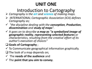
Unveiling the Art and Science of Cartography
Cartography is the intricate discipline of creating maps that visually communicate geographical information. A map serves as a symbolized image of reality, representing selected features on Earth's surface. This summary delves into the goals of cartography, the essential components of a well-designe
0 views • 65 slides
Geographic Coordinates: Importance and Significance
Explore the significance of geographic coordinates in oceanography and ecosystems. Learn why wind plays a crucial role in various oceanographic disciplines. Discover how latitude and longitude are utilized to pinpoint locations on Earth's surface, whether using degrees, minutes, seconds or decimal d
0 views • 31 slides

Lifeline Health Insurance Plans Overview
Lifeline health insurance plans offer comprehensive coverage for individuals and families. The Classic plan provides coverage for up to 4 lacs while the Supreme plan offers coverage up to 50 lacs. Key features include inpatient care, pre and post-hospitalization expenses, day-care procedures, Ayush
0 views • 20 slides
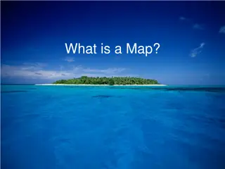
Essential Rules and Tips for Creating Quality Maps
Understanding what a map is, the rules of mapping, key features that should be included on maps (BOLTS), and essential tips for creating tasteful and easy-to-read maps. Guidelines include labeling in pencil first, horizontal labeling for human features, following natural directions for physical feat
0 views • 14 slides
Early Years Outcomes Prerequisite Skills for Geography in National Curriculum
The document outlines early years outcomes crucial for geography in the national curriculum, spanning from 30-50 months to ELG. It highlights skills like observing, questioning, understanding growth, showing care, recognizing similarities and differences, and more in young learners, preparing them f
0 views • 10 slides
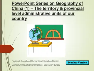
Geography of China: Territory and Administrative Units Overview
Explore the geography of China with a focus on its territory, provincial administrative units, and geographic location. Learn about the vast landmass, national borders, and key geographical features such as latitudes and coastal areas. This presentation serves as a foundational resource for understa
0 views • 16 slides
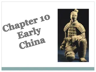
Ancient China: Birth of Civilization and Shang Dynasty
People in ancient China settled along the Huang He and the Chang Jiang rivers, utilizing the fertile soil for agriculture. The region's geographic features, including mountains and deserts, limited interactions with other civilizations. Myths and legends surround the early history, with Y the Great
0 views • 18 slides

Geographic Features: From Oceans to Volcanoes
Discover the diverse range of geographic features, from vast oceans and intricate coral reefs to winding rivers and dense forests. Learn about intriguing formations like peninsulas, isthmuses, and straits, and delve into natural wonders like sinkholes and wetlands. From coastal regions to volcanic l
0 views • 29 slides

Submarine Cable Resiliency Report Update - September 2016
This update presents the final findings of Working Group 4A on Submarine Cable Resiliency, focusing on the importance of coordinating federal, state, and local agencies to mitigate risks to submarine cable infrastructure. The report highlights the critical role of regulatory coordination and geograp
0 views • 11 slides
Submarine Cable Resiliency Update and Recommendations
Working Group 4A provides updates on the status of submarine cable resiliency, highlighting the risks to infrastructure due to lack of coordination across agencies and clustering of cable routes. The group aims to enhance regulatory coordination and promote geographic diversity to ensure network res
0 views • 7 slides
Discovering Alabama's Geography: A 4th Grade History Lesson
Explore the geographic regions of Alabama and learn about its history, economy, and political landscape in this 4th-grade history lesson. Students will identify the state's border states, major geographic provinces, and natural resources through thematic maps and interactive activities.
0 views • 19 slides
Geographic Support System Initiative (GSS-I) Overview
The Geographic Support System Initiative (GSS-I) aims to enhance address data quality through partnerships with tribal, state, county, and local governments. This program involves acquiring, verifying, and geocoding address data, with a focus on improving address coverage and spatial accuracy. Reeng
0 views • 20 slides