Geography of Europe: Features and Significance
Delve into the geographic features of Europe through maps and explanations, understanding the importance of locations such as rivers, seas, and mountains. Discover the impact of geography on economy, culture, and development, while learning about terms like peninsulas, plains, plateaus, straits, and channels. Enhance your knowledge about key locations in Europe and why they matter in a societal context.

Download Presentation

Please find below an Image/Link to download the presentation.
The content on the website is provided AS IS for your information and personal use only. It may not be sold, licensed, or shared on other websites without obtaining consent from the author.If you encounter any issues during the download, it is possible that the publisher has removed the file from their server.
You are allowed to download the files provided on this website for personal or commercial use, subject to the condition that they are used lawfully. All files are the property of their respective owners.
The content on the website is provided AS IS for your information and personal use only. It may not be sold, licensed, or shared on other websites without obtaining consent from the author.
E N D
Presentation Transcript
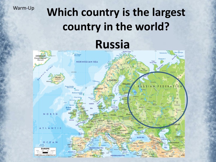
Warm-Up Which country is the largest country in the world? Russia
What does a political map show? Boundaries of different countries
Check your Political Map of Europe ____ Belgium ____ France ____ Germany ____ Italy ____ Poland ____ Russia ____ Spain ____ Ukraine ____ United Kingdom
Opening: Why does location matter? SS6G8 The student will locate selected features of Europe. a. Locate on a world and regional political- physical map: the Danube River, Rhine River, English Channel, Mediterranean Sea, European Plain, the Alps, Pyrenees, Ural Mountains, Iberian Peninsula, and Scandinavian Peninsula.
Why does location matter? location affects a society s economy, culture, and development.
Standard SS6G8 The student will locate selected features of Europe. a. Locate on a world and regional political- physical map: the Danube River, Rhine River, English Channel, Mediterranean Sea, European Plain, the Alps, Pyrenees, Ural Mountains, Iberian Peninsula, and Scandinavian Peninsula.
Vocabulary Terms - Organizer What is a peninsula? A piece of land surrounded on three sides by water and connected to a larger mass of land What is a plain? A large area of flat or gently rolling land with little forest areas What is a plateau? An elevated plain, usually with at least one steeply dropping or rising side. What is a strait? A narrow stretch of water that connects 2 larger bodies of water. What is a channel? A length of water wider than a strait, joining two larger areas of water, especially two seas
Peninsula Think Florida Think Italy Think Baja California Think Iberian Peninsula
Channel The English Channel
Plains North European Plain in Europe and the Great Plains of North America
Before the advent of modern transportation, the many waterways were vital to the growth of Europe. Water surrounds almost the entire continent. The southern coast of Europe borders the warm waters of the Mediterranean Sea. (Color blue and label) Crossroads for 3 continents (Europe, Africa, & Asia)
English Channel Waterway between Great Britain and France. It is 150 miles wide at its widest and only 21 miles wide at its narrowest. (Label and color blue) The Chunnel is an undersea rail tunnel Linking the United Kingdom and the rest Of Europe. It is 31.4 miles long.
Europe has an extensive river system. Major Rivers Rhine River Danube River Volga River These rivers allowed for movement of goods, people, & ideas throughout the continent in the past.
Rhine River (Color Blue and label) Longest and one of the Most impt. rivers in Europe. Navigable (deep & wide) for carrying trade goods inland. Flows north though Germany to the North Sea.
Danube River (Color Blue and label) Flows threw 10 different European countries. One of the most impt. commerical waterways on the continent. 2nd longest river in Europe Begins in Germany s Black Forest and ends in the Black Sea.
Landforms of Europe Europe is sometimes called a continent of peninsulas. This is because several large peninsulas, or bodies of land surrounded by water on three sides, form the European continent.
Iberian Peninsula (Color Orange/Peach) Includes: Spain & Portugal 2nd largest peninsula in Europe Lies west of France
Scandinavian Peninsula (Color Orange/Peach) Includes: Norway & Sweden & Northern Finland Rich in timber, iron, and copper
Landforms of Europe Along the jagged shorelines of the Scandinavian Peninsula are fjords. A fjord is a long, narrow, deep inlet of the sea located between steep cliffs. These were carved by glaciers during the last ice age.
Landforms of Europe Much of Europe is covered with mountains. All of the peninsulas we just saw contain mountain ranges. The highest mountains in Europe are the Alps. Draw brown peaks to show location of mts.
The Alps Major Tourist Destination
Pyrenees Mountains separate the countries Spain and France and the Iberian Peninsula from the rest of Europe (draw brown peaks for the Pyrenees)
The Ural Mountains divide the continent of Europe from Asia. (Draw brown peaks) The people on the western side of the Urals have more of a European culture, whereas those on the eastern side have a more Asiatic culture.
Not all of Europe is mountainous. A large region called the Great or North European Plain stretches from the coast of France to the Ural Mountains making it one of the largest level land areas on earth. This land is good for farming. Most people live on the plains. Color the plains green and label
The North European Plain is home to some of the world s best farmland. It also contains many rivers, which made it a great place to live in the days before modern transportation & grocery stores. A plain is a large, flat area of land, usually with few or little forest cover.