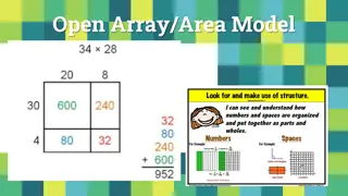
Geographic Distribution Using 3-Digit ZIP Codes
Massachusetts has approximately 685 5-digit ZIP codes assigned by the USPS, which can be aggregated into 18 3-digit ZIP codes for geographic analysis. The distribution of Emergency Department visit volumes varies across these 3-digit ZIP code boundaries, reflecting different regional characteristics. When using 3-digit ZIP codes, it's crucial to consider overlapping boundaries and variations in volume distribution across counties. This overview provides insights into the geographic distribution implications of utilizing 3-digit ZIP codes in analyzing healthcare data in Massachusetts.

Download Presentation

Please find below an Image/Link to download the presentation.
The content on the website is provided AS IS for your information and personal use only. It may not be sold, licensed, or shared on other websites without obtaining consent from the author.If you encounter any issues during the download, it is possible that the publisher has removed the file from their server.
You are allowed to download the files provided on this website for personal or commercial use, subject to the condition that they are used lawfully. All files are the property of their respective owners.
The content on the website is provided AS IS for your information and personal use only. It may not be sold, licensed, or shared on other websites without obtaining consent from the author.
E N D
Presentation Transcript
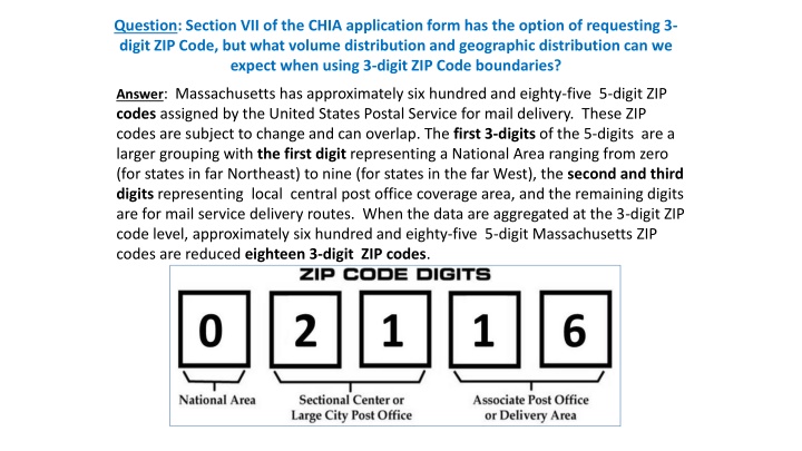
Question: Section VII of the CHIA application form has the option of requesting 3- digit ZIP Code, but what volume distribution and geographic distribution can we expect when using 3-digit ZIP Code boundaries? Answer: Massachusetts has approximately six hundred and eighty-five 5-digit ZIP codes assigned by the United States Postal Service for mail delivery. These ZIP codes are subject to change and can overlap. The first 3-digits of the 5-digits are a larger grouping with the first digit representing a National Area ranging from zero (for states in far Northeast) to nine (for states in the far West), the second and third digits representing local central post office coverage area, and the remaining digits are for mail service delivery routes. When the data are aggregated at the 3-digit ZIP code level, approximately six hundred and eighty-five 5-digit Massachusetts ZIP codes are reduced eighteen 3-digit ZIP codes.
Question: Section VII of the CHIA application form has the option of requesting 3-digit ZIP Code, but what volume distribution and geographic distribution can we expect when using 3-digit ZIP Code boundaries? (continued) Answer: The map below shows the FY2016 Massachusetts ED Visit volume by 3-digit ZIP Code and County. The eighteen 3-digit ZIP Code boundaries represent a smaller aggregation than the 12 Massachusetts Counties. Geographic coverage in larger less urban 3-digit ZIP Code areas of the Cape, Berkshire and part of Franklin County have lower ED Visit volume. Several small counties on the Cape share the same 3-digit ZIP Code. The Suffolk County 3-digit ZIP Code areas have the highest ED Visit volume. FY2016 Massachusetts Outpatient Emergency Department Visit Volume by 3-digit ZIP Code and County
Question: Section VII of the CHIA application form has the option of requesting 3-digit ZIP Code, but what volume distribution and geographic distribution can we expect when using 3-digit ZIP Code boundaries? (continued) Answer: Both FY2016 Hospital Inpatient Discharge Volume and FY2016 Observation Stay 3-digit ZIP volume mirror a geographic distribution of the FY2016 ED Visit data with less volume from the Cape, Berkshire and a part of Franklin County. When using 3-digit ZIP codes, it is important to keep in mind, while they roughly align some political boundaries, you will see more shared overlapping between ZIP code boundaries and political boundaries. Compare county and ZIP code boundaries in maps below. FY2016 Inpatient Hospital Discharge Volume by 3-digit ZIP Code and County FY2016 Outpatient Observation Stay Volume by 3-digit ZIP Code and County
Question: Section VII of the CHIA application form has the option of requesting 3-digit ZIP Code, but what volume distribution and geographic distribution can we expect when using 3-digit ZIP Code boundaries? (continued) Answer: As with 3-digit ZIP Codes, 5-digit ZIP Codes cut across multiple political boundaries. ZIP Codes generally do not show any respect for state, municipal, county, or census statistical area boundaries. They are administrative units for mail carrier routes that intertwine across political geographic boundaries like spaghetti, and are subject to continuous alteration or elimination based on mail volume. In the 5-digit ZIP code map below, the visible red lines indicate 5-digit ZIP code boundaries which cross Municipal and are shared. In the 3-digit ZIP Code map, there is a closer alignment with Municipal boundaries but sharing still visible in Western Massachusetts, Central Massachusetts and on the Cape. Massachusetts 5-digit ZIP Code Boundary overlaid on Municipal Boundaries Massachusetts 3-digit ZIP Code Boundary overlaid on Municipal Boundaries