Understanding Grid References for Map Navigation

Learn about grid references on maps, including northings and eastings, how to find specific locations using grid references, and practice exercises with answers provided. Enhance your map-reading skills with this informative guide.

Download Presentation

Please find below an Image/Link to download the presentation.
The content on the website is provided AS IS for your information and personal use only. It may not be sold, licensed, or shared on other websites without obtaining consent from the author. Download presentation by click this link. If you encounter any issues during the download, it is possible that the publisher has removed the file from their server.
E N D
Presentation Transcript
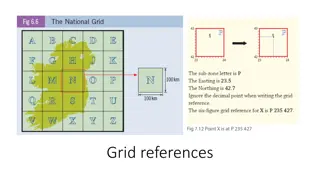
Ordnance Survey Maps The horizontal lines that run across a map are called northings - they increase in value as they go up the map from the bottom. The vertical lines that run across a map are called eastings - they increase in value as they go across the map from left to right.
4 figure grid reference It is straightforward to find a specific place using a grid reference. Grid references are easy if you can remember that you always have to go along the corridor before you go up the stairs. - To find the number of a square first use the eastings to go along the corridor until you come to the bottom left-hand corner of the square you want. Write this two-figure number down. - Then use the northing to go up the stairs until you find the same corner. Put this two-figure number after your first one and you now have the four-figure grid reference.
38 A A= 21,37 37 21 22
36 A= 13,35 A 35 B B= 12,34 34 12 13 14
4 Figure Grid References Exercise 31 = ____, ____ 30 = ____, ____ 29 = ____, ____ 28 = ____, ____ 27 03 04 05 06 07
Exercise Answers = 04,29 = 03,27 = 06,28 = 06,30