Understanding Map Projections and Coordinate Systems in QGIS

Map projections are essential for representing the Earth's surface on a flat plane, with various distortions depending on the projection used. QGIS provides tools to work with different projections like UTM, Lambert Azimuthal Equal Area, and more. Mixing projections in QGIS can lead to errors in data visualization.

Download Presentation

Please find below an Image/Link to download the presentation.
The content on the website is provided AS IS for your information and personal use only. It may not be sold, licensed, or shared on other websites without obtaining consent from the author. Download presentation by click this link. If you encounter any issues during the download, it is possible that the publisher has removed the file from their server.
E N D
Presentation Transcript
QGIS TRAINING Projections and coordinate systems
Projections and coordinate systems Projected, Geographic, datum
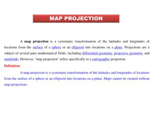
The Earth is not flat (contrary to your computer monitor/marine chart) Map Projection A map projection is any method of representing the surface of a sphere or other three-dimensional body on a plane. Map projections are necessary for creating maps. All map projections distort the surface in some fashion. Depending on the purpose of the map, some distortions are acceptable and others are not; therefore different map projections exist in order to preserve some properties of the sphere-like body at the expense of other properties. (Wikipedia) The most common projection, used for satellite imagery, is Universal Transverse Mercator (UTM)
Projections South_Pole_Lambert_Azimuthal_Equal_Area Asia_South_Albers_Equal_Area_Conic
Universal Transverse Mercator (UTM) Definitions Map projection valid from 84 N to 80 S Earth divided into 60 zones (6 wide in longitude), North or South hemisphere Coordinates are expressed as Northing and Easting in meters Example : Wallis & Futuna Wallis & Futuna intersects UTM Zones 1 and 60 South Satellite images for Wallis and Futuna islands will be in UTM 1 South
Universal Transverse Mercator (UTM) Tonga Tonga intersects UTM Zones 1 and 2 South Most images will be in UTM 1 South Samoa Samoa intersects UTM Zones 1 and 2 South Images will be in UTM 2 South
World Geographic Reference System Definitions The world geographic reference systems in an unprojected system where longitude and latitude in degrees are used as XY in a regularly spaced grid. That system induces lots of deformations on high latitudes but is commonly used to display larges zones spanning several UTM zones (the whole Pacific for example)
Mixing projections in Quantum GIS Mixing raster projections will likely produce strange results (layer not displayed or at the wrong place)
Mixing projections in Quantum GIS You can tick Enable on the fly CRS transformation to display to reproject rasters and vector layers when needed
The Earth is not a perfect sphere and gravity is not uniform Definitions In geodesy, a reference ellipsoid is a mathematically-defined surface that approximates the geoid, the truer figure of the Earth (mean sea level)
Geodetic datum Definitions A geodetic datum is a reference from which measurements are made. In surveying and geodesy, a datum is a set of reference points on the Earth's surface against which position measurements are made and (often) an associated model of the shape of the Earth (reference ellipsoid) to define a geographic coordinate system. (Wikipedia)
WGS 84 and other datums WGS 84 The World Geodetic System of 1984 (ESPG 4326) is the reference system used by satellites and GPS. Satellite images are generally provided in UTM projection and WGS 84 datum. This standard is now replacing most local grids and coordinate systems. Charts and topographic maps Old charts and topographic maps can sometimes have different projections (Transverse Mercator Vanuatu) and datums : WGS72 (ESPG 4322), Bellevue (ESPG 4714), Santo 1965 (ESPG 4730) It is especially important to check the projection and datum when digitizing a map/chart or when retrieving positions marked on a chart. In some tests a WGS 72 point wrongly interpreted as WGS 84 the position error is around 17 m, but for Bellevue datum, the error would be 925 m ! GPS should be setup to use WGS 84 datum but remember that old maps and charts are likely to use another datum
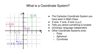
Coordinate Reference Systems Projection and datum constitute the Coordinate Reference System (CRS) of the layer. Each vector and raster layer has its own CRS, in addition to the project s CRS Earth without water


")
")