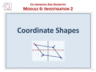
Understanding Coordinate Systems in Mathematics and Astronomy
Coordinate systems such as Cartesian, Polar, and Celestial serve as frameworks for locating points in space. They include dimensions like x, y, z axes in Cartesian, Latitude and Longitude on Earth, and various systems for astronomical observations. Different coordinate systems cater to specific purposes, from simple point plotting to complex astronomical calculations.

Download Presentation

Please find below an Image/Link to download the presentation.
The content on the website is provided AS IS for your information and personal use only. It may not be sold, licensed, or shared on other websites without obtaining consent from the author. Download presentation by click this link. If you encounter any issues during the download, it is possible that the publisher has removed the file from their server.
E N D
Presentation Transcript
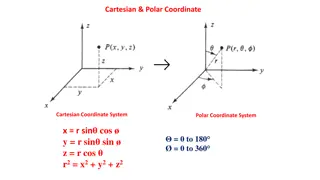
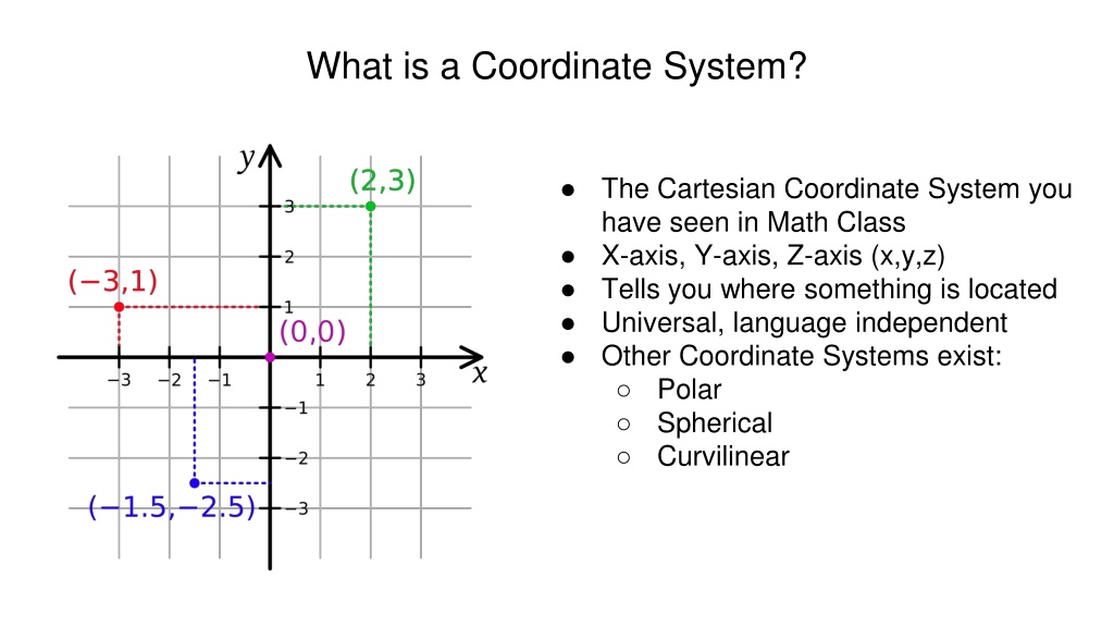
What is a Coordinate System? The Cartesian Coordinate System you have seen in Math Class X-axis, Y-axis, Z-axis (x,y,z) Tells you where something is located Universal, language independent Other Coordinate Systems exist: Polar Spherical Curvilinear
Latitude and Longitude (Lat, Lon) To the left Based on Great Circles E is center of the sphere CDE is a Great Circle AB is a small circle P is the Zenith (North Pole) To the right Lat/Lon are Great Circles Starting from the Equator, N/S are Latitude Starting from Greenwich, England, E/W are Longitude
Celestial Coordinate Systems Locate objects in space Many different Coordinate Systems exist based on equator location and purpose Assume fixed Earth and rotating sky Are somewhat analogous to Lat/Lon Types of Celestial Coordinate Systems: Horizontal Coordinate System Equatorial Coordinate System Ecliptic Coordinate System Galactic Coordinate System SuperGalactic Coordinate System
Horizontal Coordinate System Based on the Observer (you) The Equator is the Horizon Straight up from you is the Zenith Meridian is where you are facing Lat Coor. are measured from the Horizon and are called Altitude Lon Coor. are measured from Meridian and are called Azimuth Primary use: Star-Gazing
Equatorial Coordinate System Based on the Earth s Equator (Geocentric) or Sun s Equator (Heliocentric) The Zenith is the North Rotational Pole (Axis) Meridian is pointed towards Vernal Equinox at a specific time (J2000.0, B1950.0) Lat Coor. are measured from the Equator and are called Declination (Dec) Lon Coor. are measured from the Meridian and are call Right Ascension (RA) Primary use: Astronomy
Ecliptic Coordinate System Based on the Ecliptic Plane centered at either the Earth (geocentric) or Sun (heliocentric) Zenith is the Ecliptic pole (rotational axis of the Earth-sun system) Meridian is pointed towards Vernal Equinox at a specific time (J2000.0, B1950.0) Lat Coor. are measured from the Ecliptic Plane and are called Ecliptic Latitude Lon Coor. are measured from the Meridian and are call Ecliptic Longitude Primary use: Tracking the Zodiac
Galactic Coordinate System Based on the Sun as it sits in the Galactic Plane Zenith is based on height from the Galactic Plane as seen from Earth Meridian points from the Sun to the Galactic Center Lat Coor. are measured from the Galactic Plane and are called Galactic Latitude Lon Coor. are measured from the Meridian and are call Galactic Longitude Primary Use: Astronomy
SuperGalactic Coordinate System Based on the Galactic Center Zenith is based on height from the Galactic Plane as seen from Earth Meridian points from the Sun to the Galactic Center Lat Coor. are measured from the SuperGalactic Plane and are called SuperGalactic Latitude Lon Coor. are measured from the Galactic/SuperGalactic Intersection and are call Galactic Longitude Primary Use: Galaxies and Clusters
HAWC Significance Maps Race Calculations RA can be written as Hours (HRS), minutes (min) and seconds (s) but can also be written as a Decimal. To convert from HRS, min, s to a Decimal use the following equation: (HRS +(min/60)+(s/3600))x 15 For example the Crab Nebula has a RA of 5 HRS 34 min 32 s The conversion looks like: (5+(34/60)+(32/3600))x15 = 83.63
HAWC Significance Maps Race Calculations Declination (Dec) is the degree along the celestial sphere where the celestial equator is zero and the celestial pole is 90 degrees in the Northern Hemisphere. In the Southern Hemisphere the degrees go from zero to -90 degrees. Dec can be written as degrees ( ) minutes ( ) and seconds ( ) or as a Decimal. To convert from Degrees, minutes, seconds to Decimal use the following equation: (Degree + (minute/60)+ (seconds/3600) For example, the Crab Nebula has a Dec of 22 0 52 The conversion looks like: (22+(0/60)+(52/3600))= 22.01