Passive Microwave and Upcoming GPM Activities
Passive Microwave and Upcoming
GPM Activities
Science Advisory Committee Meeting
26 – 28 August, 2014
National Space Science and Technology Center, Huntsville, AL


Relevance to SPoRT and Our Partners
Relevance to SPoRT and Our Partners
1


•
A partnership has existed between SPoRT – NRL – NHC for 3 to 4
years.
•
SPoRT transitioned NRL products into NHC’s NAWIPS decision
support system. NHC desired this capability to ease their need of
using their long standing use of NRL web page for the products;
while very useful, having the data in NAWIPS provided extra
benefits.
•
Provides information in data sparse regions, mainly over water
bodies. Also can give details for precipitation structure, type, and
intensity when and where conventional IR cannot.
•
In the past year SPoRT has expanded these capabilities to other
National Centers.
Current Users and Applications
–
NHC, TAFB, SAB, CPHC
•
Hurricane monitoring (eye location/existence, ice/rain extent and inferred intensity)
•
Precipitation extent, rate, and type (stratiform / convective)
•
Precipitation in data voids, cyclone location and intensity
Potential Users and Applications
–
Coastal WFOs
•
Precipitation extent, rate, and type in radar-void areas
–
Alaska WFOs and RFC
•
Sea ice formation, movement, and melt
•
Sea Ice extent and edge
–
WFOs in General
•
Snow melt, snow cover extent and depth
•
Land surface temperatures in snow free adjacent areas
–
SPoRT
•
Sea Surface Temperatures - Inclusion into the SPoRT SST Composite
Forecast Challenges for Passive
Forecast Challenges for Passive
Microwave Observations
Microwave Observations
2
Current Products Disseminated
Current Products Disseminated
Historically, SPoRT has processed passive microwave data from NRL
1B --- Level 1B, swath brightness temperatures
1C --- Level 1C, intercalibrated swath brightness temperatures (not applicable)
2A --- Level 2A, swath precipitation rates (other products also available)
RGB’s --- Level 1B and 1C PCT’s at 37GHz and 89GHz (SPoRT)
Current latencies in hours (from satellite overpass to the end user):
3
Latencies are
approximate,
differences mostly
attributable to
distribution sizes
(granules -> orbits)
Product Generation Process
Product Generation Process
4
•
Constant query for data via ftp from NRL (soon from GSFC)
•
Level 1 and 2 products are geo-located to a common projection
•
RGB products are generated
•
Data sent to the LDM for distribution to forecast offices and
images to the SPoRT web page for internal monitoring and the
public
•
Data products for AWIPS-II, N-AWIPS, and soon in the SPoRT Web
Mapping Service (WMS)
The GPM Constellation
The GPM Constellation
GPM Core (NASA)
GMI
DPR
GPM Constellation
Partner Instruments
ATMS (NASA/NOAA)
MHS (NOAA)
AMSR2
SSMIS
SAPHIR
5
Near-Future Products
Near-Future Products
GPM Constellation will allow for passive microwave products from twelve instruments
(eleven which we will utilize), providing a greater number of overpasses per day
1B --- Level 1B, swath brightness temperatures
1C --- Level 1C, intercalibrated swath brightness temperatures
2A --- Level 2A, swath precipitation rates (other products also available)
RGB’s --- Level 1B and 1C PCT’s at 37GHz and 89GHz (SPoRT)
Latency in hours ---
Green
: From GSFC now,
Gold
: From NRL now,
Blue
: From GSFC, U/C
6
Latencies are
approximate,
differences mostly
attributable to
distribution sizes
(granules -> orbits)
* to be determined,
likely a small fraction
later than the 1C
products
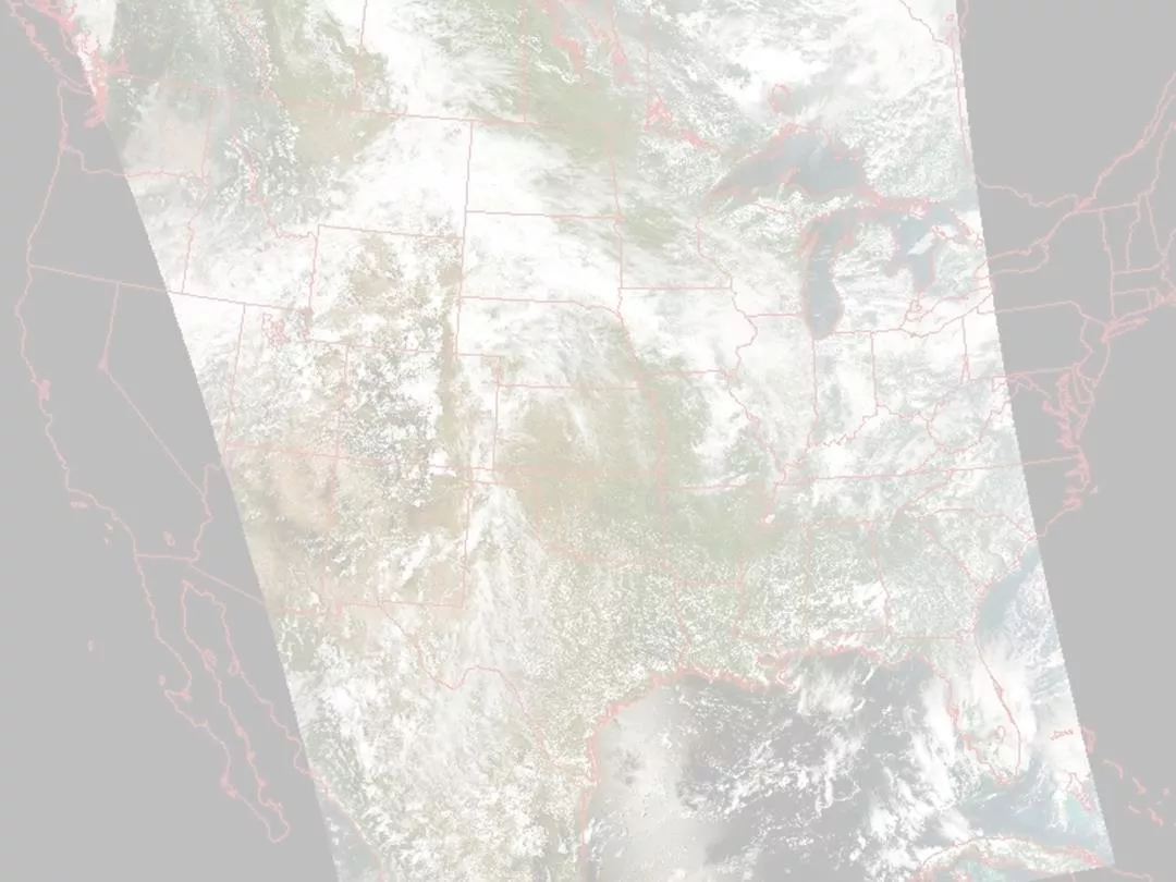
Early GMI Applications
Early GMI Applications
7
89GHz RGB from GPM of Hurricane Iselle in E.
Pacific as viewed from NHC NAWIPS display
Forecaster Feedback
•
Mark DeMaria (NHC)
commented that the inclusion of
passive microwave data into the
NHC/Tropical Proving Ground
was one of the most broadly
accepted and welcomed data
sets.
•
Forecaster at CPHC on Hurricane
Iselle (Aug 2014): “We've
definitely been looking at the
GMI imagery on NAWIPS and
through the NRL TC webpage”.
Summary
8
•
Continuing and adding partnerships
•
Migrating to use of the GPM Constellation
•
Disseminating products in N-AWIPS, AWIPS-II, and WMS
•
Largest impact to date at NHC and CPHC
•
Promotes use of NOAA & NASA microwave imagery/data
GPM Data Release Schedule
GPM Data Release Schedule
•
June 16th – GMI Level 1 Brightness Temperature swath data.
•
July 14th – GMI Level 2 Precipitation Rate swath data. This includes
precipitation rates estimated using the Goddard Profiling algorithm
(GPROF14).
•
Early September – DPR Level 2 precipitation rate data will be released via
PPS and JAXA. This includes three-dimensional swath data from the DPR Ka-
and Ku-band radars.
•
Mid-September - The DPR-GMI Level 2 combined product will be released.
•
December 2014 – NASA’s Level 3 Integrated Multi-Satellite Retrievals for
GPM (IMERG) will be released with all available data. This gridded product
will have a resolution of 0.1 degrees and updated every 30 minutes from
60⁰N-60⁰S.
This will be discussed further in the M&DA session.
A
The Passive Microwave and Upcoming GPM Activities Science Advisory Committee Meeting provided insights on forecast challenges, current products, and the product generation process related to passive microwave observations. The meeting discussed relevance to SPoRT and partner agencies, forecast challenges for current and potential users, and the dissemination of historical and current passive microwave data for various applications.

Uploaded on Mar 06, 2025 | 0 Views
Download Presentation

Please find below an Image/Link to download the presentation.
The content on the website is provided AS IS for your information and personal use only. It may not be sold, licensed, or shared on other websites without obtaining consent from the author.If you encounter any issues during the download, it is possible that the publisher has removed the file from their server.
You are allowed to download the files provided on this website for personal or commercial use, subject to the condition that they are used lawfully. All files are the property of their respective owners.
The content on the website is provided AS IS for your information and personal use only. It may not be sold, licensed, or shared on other websites without obtaining consent from the author.
E N D
Presentation Transcript
Passive Microwave and Upcoming GPM Activities Science Advisory Committee Meeting 26 28 August, 2014 National Space Science and Technology Center, Huntsville, AL
1 Relevance to SPoRT and Our Partners A partnership has existed between SPoRT NRL NHC for 3 to 4 years. SPoRT transitioned NRL products into NHC s NAWIPS decision support system. NHC desired this capability to ease their need of using their long standing use of NRL web page for the products; while very useful, having the data in NAWIPS provided extra benefits. Provides information in data sparse regions, mainly over water bodies. Also can give details for precipitation structure, type, and intensity when and where conventional IR cannot. In the past year SPoRT has expanded these capabilities to other National Centers.
2 Forecast Challenges for Passive Microwave Observations Current Users and Applications NHC, TAFB, SAB, CPHC Hurricane monitoring (eye location/existence, ice/rain extent and inferred intensity) Precipitation extent, rate, and type (stratiform / convective) Precipitation in data voids, cyclone location and intensity Potential Users and Applications Coastal WFOs Precipitation extent, rate, and type in radar-void areas Alaska WFOs and RFC Sea ice formation, movement, and melt Sea Ice extent and edge WFOs in General Snow melt, snow cover extent and depth Land surface temperatures in snow free adjacent areas SPoRT Sea Surface Temperatures - Inclusion into the SPoRT SST Composite
3 Current Products Disseminated Historically, SPoRT has processed passive microwave data from NRL 1B --- Level 1B, swath brightness temperatures 1C --- Level 1C, intercalibrated swath brightness temperatures (not applicable) 2A --- Level 2A, swath precipitation rates (other products also available) RGB s --- Level 1B and 1C PCT s at 37GHz and 89GHz (SPoRT) Current latencies in hours (from satellite overpass to the end user): Instrument Level-1B Level-1C Level-2A RGBs Notes Latencies are approximate, differences mostly attributable to distribution sizes (granules -> orbits) TMI 2.5 n/a 2.7 2.7 AMSR-E now n/a AMSR2 2.0 n/a n/a 2.2 SSM/I 2.0 n/a 2.2 2.2 F16, F17, F18 SSMIS 2.0 n/a 2.2 2.2
4 Product Generation Process Constant query for data via ftp from NRL (soon from GSFC) Level 1 and 2 products are geo-located to a common projection RGB products are generated Data sent to the LDM for distribution to forecast offices and images to the SPoRT web page for internal monitoring and the public Data products for AWIPS-II, N-AWIPS, and soon in the SPoRT Web Mapping Service (WMS)
5 The GPM Constellation GPM Core (NASA) GMI DPR GPM Constellation Partner Instruments ATMS (NASA/NOAA) MHS (NOAA) AMSR2 SSMIS SAPHIR
6 Near-Future Products GPM Constellation will allow for passive microwave products from twelve instruments (eleven which we will utilize), providing a greater number of overpasses per day 1B --- Level 1B, swath brightness temperatures 1C --- Level 1C, intercalibrated swath brightness temperatures 2A --- Level 2A, swath precipitation rates (other products also available) RGB s --- Level 1B and 1C PCT s at 37GHz and 89GHz (SPoRT) Latency in hours --- Green: From GSFC now, Gold: From NRL now, Blue: From GSFC, U/C Instrument Level-1B Level-1C Level-2A RGBs Notes * * Short-term availability TMI n/a 1.5 Latencies are approximate, differences mostly attributable to distribution sizes (granules -> orbits) * * AMSR2 n/a 1.5 * * F16, F17, F18 SSMIS n/a 1.0 * * NOAA-18, NOAA-19, METOP-A, METOP-B MHS n/a 1.5 * ATMS n/a 1.5 n/a * to be determined, likely a small fraction later than the 1C products No plans to use (183 GHz only) SAPHIR n/a 2.0 n/a n/a GMI 0.5 0.7 1.0 0.8
7 Early GMI Applications Forecaster Feedback Mark DeMaria (NHC) commented that the inclusion of passive microwave data into the NHC/Tropical Proving Ground was one of the most broadly accepted and welcomed data sets. Forecaster at CPHC on Hurricane Iselle (Aug 2014): We've definitely been looking at the GMI imagery on NAWIPS and through the NRL TC webpage . 89GHz RGB from GPM of Hurricane Iselle in E. Pacific as viewed from NHC NAWIPS display
8 Summary Continuing and adding partnerships Migrating to use of the GPM Constellation Disseminating products in N-AWIPS, AWIPS-II, and WMS Largest impact to date at NHC and CPHC Promotes use of NOAA & NASA microwave imagery/data
A GPM Data Release Schedule June 16th GMI Level 1 Brightness Temperature swath data. July 14th GMI Level 2 Precipitation Rate swath data. This includes precipitation rates estimated using the Goddard Profiling algorithm (GPROF14). Early September DPR Level 2 precipitation rate data will be released via PPS and JAXA. This includes three-dimensional swath data from the DPR Ka- and Ku-band radars. Mid-September - The DPR-GMI Level 2 combined product will be released. December 2014 NASA s Level 3 Integrated Multi-Satellite Retrievals for GPM (IMERG) will be released with all available data. This gridded product will have a resolution of 0.1 degrees and updated every 30 minutes from 60 N-60 S. This will be discussed further in the M&DA session.