Pandora Advanced Validation Capabilities for NO2 Monitoring
Pandora advanced validation capabilities for NO2 monitoring involve measurement techniques such as Total and Tropospheric columns of NO2 through direct sun and MAX-DOAS methods, with emphasis on spatial coverage dependent on various factors. The system provides real-time near-surface concentrations, total tropospheric columns, and profiles of NO2, HCHO, O3, SO2, and H2O. Pandora utilizes sophisticated inversion algorithms for MAX-DOAS interpretation, considering aerosol/cloud impact and optimal estimation using radiative transfer calculations. Further validation and complex measurement strategies are deemed necessary, especially under high emission scenarios. Various in-situ instruments and experiments are employed to validate the spatial coverage and measurements.

Uploaded on Oct 02, 2024 | 2 Views
Download Presentation

Please find below an Image/Link to download the presentation.
The content on the website is provided AS IS for your information and personal use only. It may not be sold, licensed, or shared on other websites without obtaining consent from the author.If you encounter any issues during the download, it is possible that the publisher has removed the file from their server.
You are allowed to download the files provided on this website for personal or commercial use, subject to the condition that they are used lawfully. All files are the property of their respective owners.
The content on the website is provided AS IS for your information and personal use only. It may not be sold, licensed, or shared on other websites without obtaining consent from the author.
E N D
Presentation Transcript
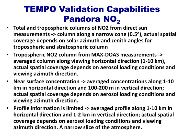
TEMPO Validation Capabilities Pandora NO2 Total and tropospheric columns of NO2 from direct sun measurements -> column along a narrow cone (0.5o), actual spatial coverage depends on solar azimuth and zenith angles for tropospheric and stratospheric column Tropospheric NO2 column from MAX-DOAS measurements -> averaged column along viewing horizontal direction (1-10 km), actual spatial coverage depends on aerosol loading conditions and viewing azimuth direction. Near surface concentration -> averaged concentrations along 1-10 km in horizontal direction and 100-200 m in vertical direction; actual spatial coverage depends on aerosol loading conditions and viewing azimuth direction. Profile information is limited -> averaged profile along 1-10 km in horizontal direction and 1-2 km in vertical direction; actual spatial coverage depends on aerosol loading conditions and viewing azimuth direction. A narrow slice of the atmosphere.
Pandora TEMPO validation capabilities Three products will be available from the MAX-DOAS data: Real time near surface concentrations Total tropospheric columns Profile information of NO2, HCHO, O3, SO2, H2O Fast azimuthal scans can provide areal view with a diameter of 2-20 km Deploying multiple Pandoras at the same location will increase temporal resolution
Pandora Inversion Algorithms for MAX-DOAS interpretation Aerosols/clouds impact light path retrieval of trace gases depends on correct aerosol/cloud representation 1. Real time 2. Intensity fitting SCD: NO2, HCHO, O3, SO2, H2O and O2O2 Combination of different elevation angle measurements (1, 2, 15, 20, 30, 90o) Near surface concentrations, tropospheric total columns, some profile information Optimal estimation using on-line radiative transfer calculations (VLIDORT) Aerosol Ext. Coef. Profile, SSA, ASY factor, Surface Albedo Trace gas profiles
Pandora Validation PANDORA MAX-DOAS data need further validation (spatial averaging, trace gas spatial gradients, aerosol loading) DISCOVER-AQ demonstrated that the real situation is more complicated than expected. Not well represented by model studies More complex measurement strategies are needed to validate Pandora near surface NO2 concentrations and profiles, especially during high emission periods with large temporal and special heterogeneity. Need to account for azimuthal inhomogeneity and different profile shapes
Pandora validation: Tethered Balloon at 400m better designed experiments are needed to understand and validate MAX-DOAS spatial coverage: NO2 Sonde instrument NO2 Sonde instrument In-situ at 200 m - multiple in-situ measurements - long pass DOAS - mobile measurements In-situ at 150 m In-situ at 100 m In-situ at 50 m In-situ mobile In-situ at surface, 1 km away from Pandora In-situ 3 km away from Pandora In-situ near the Pandora LP-DOAS and mobile: Up to 10 km travel along the view direction
Near surface O3 volume mixing ratios at Moody Tower (preliminary)