MACHC & NOAA Collaborative Oceanographic Project
An overview of the joint effort between the MACHC and NOAA, focusing on hydrographic data collection and analysis in the Meso-American and Caribbean Sea regions. The report highlights the role of the Naval Meteorology and Oceanography Command and National Geospatial-Intelligence Agency in this project, with detailed findings from December 2017.
Download Presentation

Please find below an Image/Link to download the presentation.
The content on the website is provided AS IS for your information and personal use only. It may not be sold, licensed, or shared on other websites without obtaining consent from the author. Download presentation by click this link. If you encounter any issues during the download, it is possible that the publisher has removed the file from their server.
E N D
Presentation Transcript
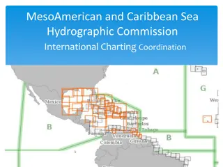
United States of America Meso-American and Caribbean Sea Hydrographic Commission (MACHC) National Oceanic and Atmospheric Administration Naval Meteorology and Oceanography Command National Geospatial-Intelligence Agency December 2017
U.S. Hydrographic Leadership NOAA o U.S. National Hydrographer & Director, Office of Coast Survey and U.S. Rear Admiral Shep Smith o Deputy Director, Office of Coast Survey Katie Ries NGA o Chief Hydrographer John Lowell o Director Maritime Safety Office Captain Brian Conon Navy o Commander Naval Meteorological and Oceanography Command (CNMOC) Oceanographer of the Navy, Hydrographer of the Navy, and Navigator of the Navy Rear Admiral John Okon o Deputy Hydrographer of the Navy Stanley Harvey
Main Achievements o Nautical Information System (NIS) Data Base Load Completed o National Charting Plan o New NOAA CAT B Cartography Program o International Chart Adequacy Workshop o MSI Training Course (Barbados) o Capacity Building Efforts in Haiti o Post-Hurricane Assistance Disaster Response Website
Post-Hurricane Assistance U.S. NGA Disaster Response Site- http://nga.maps.arcgis.com/apps/MapAndAppGallery/index.html?appid=85c45e0712 93405ba0926b75d740f83e
Main Challenges/Obstacles o Challenging Post Hurricanes (Harvey, Irma, and Maria) Assistance https://www.nga.mil/Pages/default.aspx o SeaBed 2030 http://seasket.ch/OwJiQE0h0k o New Survey Prioritization Model
Update on C-55 Hydrographic Surveys-U.S. portion of the MACHC Region A B C Depths < 200m 13% 55% 32% Depths > 200m 59% 41% .05% Charts published by the U.S. in the MACHC region (See Report) Purpose/Scale A B C Offshore passage/Small 100% 100% 100% Landfall and Coastal passage/Medium 100% 100% 100% Approaches and Ports/Large 100% 100% 100% Percentage of Group A showing depths in metres <1.0% Percentage of Group A referenced to a satellite datum 100% Coverage of charts published by the U.S. in the MACHC region Purpose/Scale A B C Offshore passage/Small 100% 100% 100% Landfall and Coastal passage/Medium 100% 100% 100% Approaches and Ports/Large 100% 100% 100% Percentage of Group A showing depths in metres 3.0% Percentage of Group A referenced to a satellite datum 100%
Non-U.S. Regional Chart Coverage Four New Paper Chart Editions Distribution Chart 24502 27085 24465 24462 Chart Title Edition Date March 2017 April 2017 July 2017 August 2017 Barranquilla, Colombia Bahia de la Habana, Cuba Sint Anna Baai and Schottegat, Curacao, Netherland Antilles Curacao, Netherland Antilles LIM DIS LIM DIS LIM DIS LIM DIS One new INT Chart to be Produced in 2018 INT No. Nat No. Producing Agency Title Projected Availability 4021 26025 NGA Eastern Cuba to Puerto Rico FY2018 Two New ENCs in Progress Cell Title Posted Name US3HTI01 Haiti Coast In Progress US511060 Puerto de Haina, Dominican Republic In Progress
Plans that affect the Region o Fourth International Chart Adequacy Workshop July 2018 For interest in 2018 course, contact: Dr. Shachak Pe eri at shachack.peeri@noaa.gov o Tide and Water Levels Training Planned for late 2018 - Contact Peter Stone at Peter.Stone@noaa.gov
Capacity Building Activities 2017 o International Chart Adequacy Workshop July 2017 in Silver Spring, MD (12 Nations) For interest in 2018 course, contact: Dr. Shachak Pe eri at shachack.peeri@noaa.gov o MSI training in FY 2017 in Barbados MSI Coordinator Peter Doherty at: Peter.M.Doherty@nga.mil Other Training Opportunities o The International Hydrographic Science Applications Program (CAT A) at the University of Southern Mississippi Course Identifier: MASL# PP-169265 Contact US Naval Attach at US Embassy
Other Opportunities (continued) o The International Hydrographic Management and Engineering Program (CAT B) Course Identifier: MASL# PP-169265 - Contact US Naval Attach at US Embassy o CAT A certified hydrographic programs University of New Hampshire Contact: Andy Armstrong at: andy.armstrong@noaa.gov. o U.S. Navy standing by with a Fleet Survey Team in response to recent Hurricanes Support safety of Navigation Analyzed Imagery Contact: Naval Attach at US Embassy
Capacity Building Activities o Technical Visit to Haiti Assess Current Capacity and Capability Support efforts to become full Member of IHO
Lessons Learned oThe Disaster Response website, while useful, could be improved with more interactive options (http://nga.maps.arcgis.com/apps/MapA ndAppGallery/index.html?appid=85c45e 071293405ba0926b75d740f83e)
Thank you! (Wish we were here!)
