NOAA Hurricane Forecasting Models Overview
The NOAA hurricane forecasting models include HWRF, POM, HYCOM, HMON, covering regions like the Pacific, Indian Ocean, North Atlantic, and Gulf of Mexico. These models utilize a combination of climatology data, feature models, and real-time RTOFS inputs for initialization and forecasting. Various configurations and components such as dynamic cores, data assimilation, physics packages, and post-processing techniques are employed to improve accuracy in hurricane prediction.

Download Presentation

Please find below an Image/Link to download the presentation.
The content on the website is provided AS IS for your information and personal use only. It may not be sold, licensed, or shared on other websites without obtaining consent from the author.If you encounter any issues during the download, it is possible that the publisher has removed the file from their server.
You are allowed to download the files provided on this website for personal or commercial use, subject to the condition that they are used lawfully. All files are the property of their respective owners.
The content on the website is provided AS IS for your information and personal use only. It may not be sold, licensed, or shared on other websites without obtaining consent from the author.
E N D
Presentation Transcript
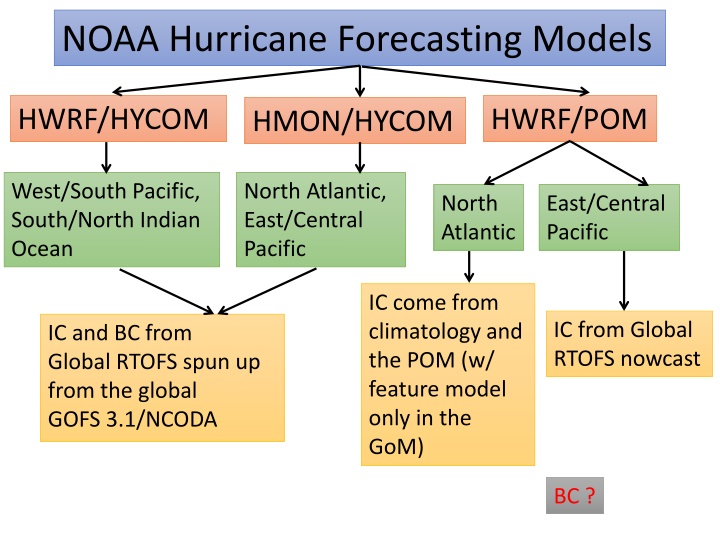
NOAA Hurricane Forecasting Models HWRF/POM HWRF/HYCOM HMON/HYCOM West/South Pacific, South/North Indian Ocean North Atlantic, East/Central Pacific North Atlantic East/Central Pacific IC come from climatology and the POM (w/ feature model only in the GoM) IC from Global RTOFS nowcast IC and BC from Global RTOFS spun up from the global GOFS 3.1/NCODA BC ?
NOAA Hurricane Forecasting Models HMON/HYCOM HWRF/POM HWRF/HYCOM North Atlantic East Pacific West Pacific Central Pacific North Indian South Indian South Pacific
NOAA Hurricane Forecasting Models HMON/HYCOM HWRF/POM HWRF/HYCOM West/South Pacific, South/North Indian Ocean North Atlantic, East/Central Pacific North Atlantic East/Central Pacific IC come from climatology and the POM (w/ feature model only in the GoM) IC from Global RTOFS nowcast IC and BC from Global RTOFS spun up from the global GOFS 3.1/NCODA
Avichel asked us not to share outside MARACOOS until official release FY2018 HWRF/HMON Configuration (maintain diversity for future) Note: Items in Red are different HWRF HMON Dynamic core Non-hydrostatic, NMM-E Non-hydrostatic, NMM-B Nesting 13.5/4.5/1.5 km; 77 /18 /6 ; 75 vertical levels; Full two- way moving 18/6/2 km; 75 /12 /8 ; 51 vertical levels; Full two- way moving Data Assimilation and Initialization Vortex relocation & adjustment, Self-cycled hybrid EnKF-GSI with inner core DA (TDR) Modified vortex relocation & adjustment, no DA Physics Updated surface (GFDL), GFS-EDMF PBL, Updated Scale- aware SAS, NOAH LSM, Modified RRTM, Ferrier Surface (GFDL), GFS-EDMF PBL, Scale-aware SAS, NOAH LSM, RRTM, Ferrier Coupling MPIPOM/HYCOM, RTOFS/GDEM, WaveWatch-III HYCOM, RTOFS/NCODA, No waves Post-processing NHC interpolation method, Updated GFDL tracker NHC interpolation method, GFDL tracker NEMS/NUOPC No Yes with moving nests Computation cost for forecast job 81 nodes in 98 mins 26 nodes in 95 mins
Global RTOFS day 1 day -2 day 0 IC from Global GOFS 3.1/NCODA 0Z 6Z 12Z 18Z 0Z Forcing EMC GDAS Forcing GFS IC, BC IC Regional HMON/HYCOM HWRF/HYCOM IC IC IC
Hurricane Forecasting Models by Regions Gulf of Mexico HWRF/POM: initialized from climatology and/or feature models. HMON/HYCOM: initialized from RTOFS. RTOFS Initializes from GOFS 3.1/NCODA 2 days prior (initial conditions ) forced by EMC GDAS (Global data assimilation system) forcing.
HWRF runs in 7 individual basins West Pacific, South Pacific, Southern Indian Ocean, Northern Indian Ocean. In all these basins HWRF is Coupled to HYCOM using IC/BC from global RTOFS NHC (National Hurricane Center) basins: HWRF Coupled to POM In the North Atlantic. Initial conditions come from climatology and feature model. Feature model only for the GOM but not the Gulf Stream. Eastern Pacific and Central Pacific. IC come from global RTOFS JTWC (joint typhoon weather center) basins:
HMON runs only in NHC basins global RTOFS HMON is coupled to HYCOM. IC come from Global RTOFS forcing In the different basins, HYCOM is a subset of the global RTOFS. Regional HYCOM uses initial conditions (IC) and boundary conditions (BC) from global global RTOFS initialized from GOFS3.1/NCODA Validations to the global RTOFS are done daily in the EMC website: https://polar.ncep.noaa.gov/global/ It is HYCOM, the same as GOFS 3.1 but uses GDAS
Michael and provide us with output so the three models can be compared vs glider data The output provided by Hyun-Sook is the 5th cycle The experimental system is HWRF/HYCOM in NHC basins Hyun-Sook will run experimental HWRF/HYCOM for
Front Eddy Analysis It is only done in GOM NHC gives NCEP the location of the Loop Current and warm core rings based on SST and SSH. This information is sent daily The locations of Loop Currents and warm core rings go into POM and modifies the climatology of temperature and salinity (subsurface profiles). This modified climatology becomes the IC for POM There are Netcdf files that are created with the modified climatology: pom.ts_initial.nc pom.uv_initial.nc (geostrophy) pom.el_initial.nc (initial elevation)
(There are files). You should have them. They came with runs from HWRF/HYCOM with FV3 If the Loop Current and warm core file are not provided, then POM initializes from climatology