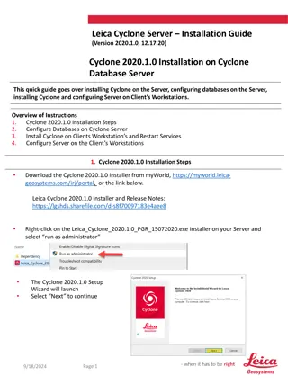
Enhancements to COAMPS Tropical Cyclone Forecasting Methods


A
p
p
l
i
c
a
t
i
o
n
a
n
d
I
m
p
r
o
v
e
m
e
n
t
s
t
o
C
O
A
M
P
S
-
T
C
Richard M. Hodur
1
, J. Doyle
2
, E. Hendricks
2
, Y. Jin
2
, J. Moskaitis
2
, K. Sashegyi
2
, J. Schmidt
2
1
Innovative Employee Solutions/Science Applications International Corporation,
Monterey, CA
2
Naval Research Laboratory, Monterey, CA
2013 IHC/Tropical Cyclone Research Forum
College Park, MD
4-8 March 2013
A
p
p
l
i
c
a
t
i
o
n
a
n
d
I
m
p
r
o
v
e
m
e
n
t
s
t
o
C
O
A
M
P
S
-
T
C
O
u
t
l
i
n
e
•
Current Methodology
•
Synthetic Observations
•
Real-Time Run Methodology
•
Proposed New Methodology
•
New Synthetics
•
Dynamic Initialization
•
Conclusion and Future Plans
Synthetic TC Observations
Purpose
Create observations of the TC circulation, making up for the lack of real-time in-
situ observations
C
u
r
r
e
n
t
M
e
t
h
o
d
o
l
o
g
y
•
Fixed radii @ 0.5°, 1°, 2°, 3°, 4°, and 6°
•
8 profiles per radial ring
•
u-, v-, T, z values at each point
•
Modified Rankine vortex
•
9 levels from 1000 to 400 mb
•
Fixed vertical profile/No vertical tilt
•
Current storm motion included
•
Large-scale shear added
TC Synthetics for Ernesto 2012
TC Analysis with NAVDAS
Sandy:
2012102500 Analysis
Relocate TC/Grid
Assimilate TC synthetics
and all other real-time
observations
NAVDAS:
NRL Atmospheric Variational Data Assimilation System
First-Guess Field
Final Analysis
Cold Start
Global Analyses
NAVDAS
120-h Forecast
Global Forecast
Fields - LBC
Observations
TC Synthetics
SST Analysis
COAMPS Real-Time Run Methodology
P
e
r
f
o
r
m
e
d
i
n
2
0
0
8
-
2
0
0
9
@
A
F
D
S
R
C
,
2
0
1
0
-
2
0
1
3
@
N
a
v
y
D
S
R
C
Observations and
TC Synthetics are
used together in
NAVDAS to
generate the initial
fields for the model
Warm Start
6-h Forecast
Fields
A 2-d ocean SST
analysis (NCODA) is
used to produce
the SST field that is
held constant
during each
forecast
Cold Start
Global Analyses
NAVDAS
120-h Forecast
Global Forecast
Fields - LBC
Observations
TC Synthetics
SST Analysis
COAMPS Real-Time Run Methodology
P
e
r
f
o
r
m
e
d
i
n
2
0
0
8
-
2
0
0
9
@
A
F
D
S
R
C
,
2
0
1
0
-
2
0
1
3
@
N
a
v
y
D
S
R
C
The first time the
system is run for a
TC, a cold start is
done, so global
fields are used for
the first-guess
fields and for the
lateral boundary
conditions
Warm Start
6-h Forecast
Fields
NAVDAS
120-h Forecast
Global Forecast
Fields - LBC
Observations
TC Synthetics
SST Analysis
COAMPS Real-Time Run Methodology
Warm Start
After the first time
that COAMPS-TC is
run for a system,
warm starts are
done and the
global model fields
are used only to
supply the lateral
boundary
conditions
COAMPS-TC Areas
•
Triple nested grids: 45/15/5 km
•
Inner grids:
•
Move with the TC
•
121x121 (15 km), 181x181 (5 km)
•
Multiple storms in any basin are run
separately
Synthetic TC Observations: New
Purpose
Create a new set of observations of the TC circulation that can be adapted for
different sized storms
P
r
o
p
o
s
e
d
N
e
w
M
e
t
h
o
d
o
l
o
g
y
•
Variable positioning of the radial rings:
•
One ring for the RMW (observed or first-guess)
•
User-defined density (# of rings, # of synthetics
per ring, and ring spacing)
•
User-defined radii of outer-ring
•
Any number of profiles per radial ring
•
u-, v-, T, z values
•
Modified Rankine vortex
•
7 levels from 1000 to 400 mb
•
Fixed vertical profile/No vertical tilt
•
Current storm motion included
•
Large-scale shear added
TC Synthetics
for Ernesto
05L/2012
TC Synthetics
for invest area
98W/2013
Pre-Retro Test Cases
9
9
C
a
s
e
s
f
r
o
m
2
0
1
0
,
2
0
1
1
,
a
n
d
2
0
1
2
COAMPS-TC Track Forecasts
Old vs. New TC Synthetics
Ernesto (2012/05L)
Old Synthetics
New Synthetics
The new synthetics led to improved track forecasts for
Ernesto, particularly in it’s early stages
COAMPS-TC Track Forecasts
Old vs. New TC Synthetics
Katia (2011/12L)
The new synthetics led to improved track forecasts for
Katia, particularly during recurvature
Effect of Synthetic Observations on
COAMPS-TC Track Forecast Errors
Old
(‘control’, blue)
vs. New
(‘b’, green)
TC Synthetics
The average
track error over
all storms was
lower using the
new synthetics
for all forecast
times.
Effect of Synthetic Observations on
COAMPS-TC Intensity Forecast Errors
Old
(‘control’, blue)
vs. New
(‘b’, green)
TC Synthetics
The average
intensity error
over all storms
was lower using
the new
synthetics
during the 30-
102 h time
period.
Initial “spin-down”
Cold Start
Global Analyses
NAVDAS
120-h Forecast
Global Forecast
Fields - LBC
Observations
TC Synthetics
SST Analysis
COAMPS Real-Time Run Methodology
P
e
r
f
o
r
m
e
d
i
n
2
0
0
8
-
2
0
0
9
@
A
F
D
S
R
C
,
2
0
1
0
-
2
0
1
3
@
N
a
v
y
D
S
R
C
Reminder
This is the method
that is currently
used for running
COAMPS-TC
Warm Start
6-h Forecast
Fields
Cold Start
Global Analyses
NAVDAS
120-h Forecast
Global Forecast
Fields - LBC
Observations
Remove TC Vortex
Insert TC Vortex
12-h DI Forecast
SST Analysis
COAMPS Proposed Run Methodology
T
C
D
I
/
D
I
:
T
r
o
p
i
c
a
l
C
y
c
l
o
n
e
D
y
n
a
m
i
c
I
n
i
t
i
a
l
i
z
a
t
i
o
n
/
D
y
n
a
m
i
c
I
n
i
t
i
a
l
i
z
a
t
i
o
n
Hendricks et al. (2011)
WAF
, Zhang et al. (2012)
WAF,
Hendricks et al. (2013)
MWR
, submitted
TCDI
DI
Warm Start
6-h Forecast
Fields
Effect of TCDI/DI on COAMPS-TC
Track Forecast Errors
Old
(‘control’, blue)
vs. TCDI/DI
(‘c’, green)
The average
track error over
all storms was
unchanged
using the
TCDI/DI
methodology
for all forecast
times.
Effect of TCDI/DI on COAMPS-TC
Intensity Forecast Errors
Old
(‘control’, blue)
vs. TCDI/DI
(‘c’, green)
The average
intensity error
over all storms
was lower using
TCDI/DI during
the 6-54 h time
period.
Also, the initial
spin-down was
eliminated.
Cold Start
Global Analyses
NAVDAS
120-h Forecast
Global Forecast
Fields - LBC
Observations
New TC Synthetics
12-h DI Forecast
SST Analysis
COAMPS Proposed Run Methodology
N
S
/
D
I
:
N
e
w
S
y
n
t
h
e
t
i
c
s
/
D
y
n
a
m
i
c
I
n
i
t
i
a
l
i
z
a
t
i
o
n
Warm Start
6-h Forecast Fields
Conclusion and Future Plans
COAMPS-TC
•
Real-time applications (2008-2012)
•
New synthetics:
•
Improved track forecasts
•
Improved intensity forecasts
•
TCDI/DI:
•
No change to track forecasts
•
Improved intensity forecasts
•
Eliminates initial spin-down
•
Next steps:
•
New synthetics
•
DI
•
2013 retro cases and real-time forecasts
A
p
p
l
i
c
a
t
i
o
n
a
n
d
I
m
p
r
o
v
e
m
e
n
t
s
t
o
C
O
A
M
P
S
-
T
C
Richard M. Hodur
1
, J. Doyle
2
, E. Hendricks
2
, Y. Jin
2
, J. Moskaitis
2
, K. Sashegyi
2
, J. Schmidt
2
1
Innovative Employee Solutions/Science Applications International Corporation,
Monterey, CA
2
Naval Research Laboratory, Monterey, CA
2013 IHC/Tropical Cyclone Research Forum
College Park, MD
4-8 March 2013
This presentation discusses the application of new methodologies in COAMPS for improving tropical cyclone forecasting. It covers synthetic TC observations, analysis with NAVDAS, and the real-time run methodology for generating initial fields in the model. The incorporation of observations and TC synthetics enhances the accuracy of forecasts, demonstrating advancements in storm prediction techniques.

Download Presentation

Please find below an Image/Link to download the presentation.
The content on the website is provided AS IS for your information and personal use only. It may not be sold, licensed, or shared on other websites without obtaining consent from the author. Download presentation by click this link. If you encounter any issues during the download, it is possible that the publisher has removed the file from their server.
E N D
Presentation Transcript
Application and Improvements to Application and Improvements to COAMPS COAMPS- -TC TC Richard M. Hodur1, J. Doyle2, E. Hendricks2, Y. Jin2, J. Moskaitis2, K. Sashegyi2, J. Schmidt2 1Innovative Employee Solutions/Science Applications International Corporation, Monterey, CA 2Naval Research Laboratory, Monterey, CA 2013 IHC/Tropical Cyclone Research Forum College Park, MD 4-8 March 2013
Application and Improvements to Application and Improvements to COAMPS COAMPS- -TC Outline TC Current Methodology Synthetic Observations Real-Time Run Methodology Proposed New Methodology New Synthetics Dynamic Initialization Conclusion and Future Plans
Synthetic TC Observations Purpose Create observations of the TC circulation, making up for the lack of real-time in- situ observations Current Methodology Current Methodology Fixed radii @ 0.5 , 1 , 2 , 3 , 4 , and 6 8 profiles per radial ring u-, v-, T, z values at each point Modified Rankine vortex 9 levels from 1000 to 400 mb Fixed vertical profile/No vertical tilt Current storm motion included Large-scale shear added TC Synthetics for Ernesto 2012
TC Analysis with NAVDAS Sandy: 2012102500 Analysis Relocate TC/Grid Assimilate TC synthetics and all other real-time observations First-Guess Field Final Analysis NAVDAS: NRL Atmospheric Variational Data Assimilation System
COAMPS Real-Time Run Methodology Performed in 2008-2009 @ AF DSRC, 2010-2013 @ Navy DSRC Cold Start Global Analyses Observations and TC Synthetics are used together in NAVDAS to generate the initial fields for the model Observations NAVDAS TC Synthetics Warm Start 6-h Forecast Fields A 2-d ocean SST analysis (NCODA) is used to produce the SST field that is held constant during each forecast 120-h Forecast SST Analysis Global Forecast Fields - LBC
COAMPS Real-Time Run Methodology Performed in 2008-2009 @ AF DSRC, 2010-2013 @ Navy DSRC Cold Start Global Analyses The first time the system is run for a TC, a cold start is done, so global fields are used for the first-guess fields and for the lateral boundary conditions Observations NAVDAS TC Synthetics 120-h Forecast SST Analysis Global Forecast Fields - LBC
COAMPS Real-Time Run Methodology Warm Start After the first time that COAMPS-TC is run for a system, warm starts are done and the global model fields are used only to supply the lateral boundary conditions Observations NAVDAS TC Synthetics Warm Start 6-h Forecast Fields 120-h Forecast SST Analysis Global Forecast Fields - LBC
COAMPS-TC Areas Western North Pacific: 281x151 Western North Atlantic: 281x151 Central and East North Pacific: 321x151 Arabian Sea and Bay of Bengal: 281x151 Triple nested grids: 45/15/5 km Inner grids: Move with the TC 121x121 (15 km), 181x181 (5 km) Multiple storms in any basin are run separately SW Pacific and South Indian Ocean: 521x151
Synthetic TC Observations: New Purpose Create a new set of observations of the TC circulation that can be adapted for different sized storms Proposed New Methodology Proposed New Methodology Variable positioning of the radial rings: One ring for the RMW (observed or first-guess) User-defined density (# of rings, # of synthetics per ring, and ring spacing) User-defined radii of outer-ring Any number of profiles per radial ring u-, v-, T, z values Modified Rankine vortex 7 levels from 1000 to 400 mb Fixed vertical profile/No vertical tilt Current storm motion included Large-scale shear added TC Synthetics for Ernesto 05L/2012 TC Synthetics for invest area 98W/2013
Pre-Retro Test Cases 99 Cases from 2010, 2011, and 2012 TC Name Start End # of cases 07L 11L 09L 12L 14L 17L 05L 09L 18L 19L Earl Igor Irene Katia Maria Philippe Ernesto Isaac Sandy Tony 2010082600 2010091012 2011082212 2011083000 2011090700 2011092812 2012080200 2012082112 2012102300 2012102300 2010090112 2010091512 2011082512 2011090512 2011091212 2011100312 2012080500 2012082600 2012102700 2012102412 14 11 7 14 12 11 7 10 9 4
COAMPS-TC Track Forecasts Old vs. New TC Synthetics Ernesto (2012/05L) Old Synthetics New Synthetics The new synthetics led to improved track forecasts for Ernesto, particularly in it s early stages
COAMPS-TC Track Forecasts Old vs. New TC Synthetics Katia (2011/12L) Old Synthetics New Synthetics The new synthetics led to improved track forecasts for Katia, particularly during recurvature
Effect of Synthetic Observations on COAMPS-TC Track Forecast Errors Old ( control , blue) vs. New ( b , green) TC Synthetics The average track error over all storms was lower using the new synthetics for all forecast times.
Effect of Synthetic Observations on COAMPS-TC Intensity Forecast Errors Old ( control , blue) vs. New ( b , green) TC Synthetics The average intensity error over all storms was lower using the new synthetics during the 30- 102 h time period. Initial spin-down
COAMPS Real-Time Run Methodology Performed in 2008-2009 @ AF DSRC, 2010-2013 @ Navy DSRC Cold Start Global Analyses Reminder This is the method that is currently used for running COAMPS-TC Observations NAVDAS TC Synthetics Warm Start 6-h Forecast Fields 120-h Forecast SST Analysis Global Forecast Fields - LBC
COAMPS Proposed Run Methodology TCDI/DI: Tropical Cyclone Dynamic Initialization/Dynamic Initialization Hendricks et al. (2011) WAF, Zhang et al. (2012) WAF, Hendricks et al. (2013) MWR, submitted Cold Start Global Analyses Observations NAVDAS Warm Start 6-h Forecast Fields Remove TC Vortex TCDI Insert TC Vortex ?? ??= ?(? ??) 120-h Forecast 12-h DI Forecast DI SST Analysis Global Forecast Fields - LBC
Effect of TCDI/DI on COAMPS-TC Track Forecast Errors Old ( control , blue) vs. TCDI/DI ( c , green) The average track error over all storms was unchanged using the TCDI/DI methodology for all forecast times.
Effect of TCDI/DI on COAMPS-TC Intensity Forecast Errors Old ( control , blue) vs. TCDI/DI ( c , green) The average intensity error over all storms was lower using TCDI/DI during the 6-54 h time period. Also, the initial spin-down was eliminated.
COAMPS Proposed Run Methodology NS/DI: New Synthetics/Dynamic Initialization Cold Start Global Analyses Observations NAVDAS New TC Synthetics ?? ??= ?(? ??) 12-h DI Forecast Warm Start 6-h Forecast Fields 120-h Forecast SST Analysis Global Forecast Fields - LBC
Conclusion and Future Plans COAMPS-TC Real-time applications (2008-2012) New synthetics: Improved track forecasts Improved intensity forecasts TCDI/DI: No change to track forecasts Improved intensity forecasts Eliminates initial spin-down Next steps: New synthetics DI 2013 retro cases and real-time forecasts
Application and Improvements to Application and Improvements to COAMPS COAMPS- -TC TC Richard M. Hodur1, J. Doyle2, E. Hendricks2, Y. Jin2, J. Moskaitis2, K. Sashegyi2, J. Schmidt2 1Innovative Employee Solutions/Science Applications International Corporation, Monterey, CA 2Naval Research Laboratory, Monterey, CA 2013 IHC/Tropical Cyclone Research Forum College Park, MD 4-8 March 2013