Collaborative Project with La Perla Neighborhood: Mapping for Empowerment
Explore the collaborative efforts between Worcester Polytechnic Institute (WPI) and La Perla community in Puerto Rico, focusing on mapping initiatives to empower residents. The project aims to build relationships, engage in dialogue, and create mapping resources for software applications in La Perla. Learn about the history, challenges, and goals of this meaningful partnership.

Uploaded on Oct 06, 2024 | 0 Views
Download Presentation

Please find below an Image/Link to download the presentation.
The content on the website is provided AS IS for your information and personal use only. It may not be sold, licensed, or shared on other websites without obtaining consent from the author. Download presentation by click this link. If you encounter any issues during the download, it is possible that the publisher has removed the file from their server.
E N D
Presentation Transcript
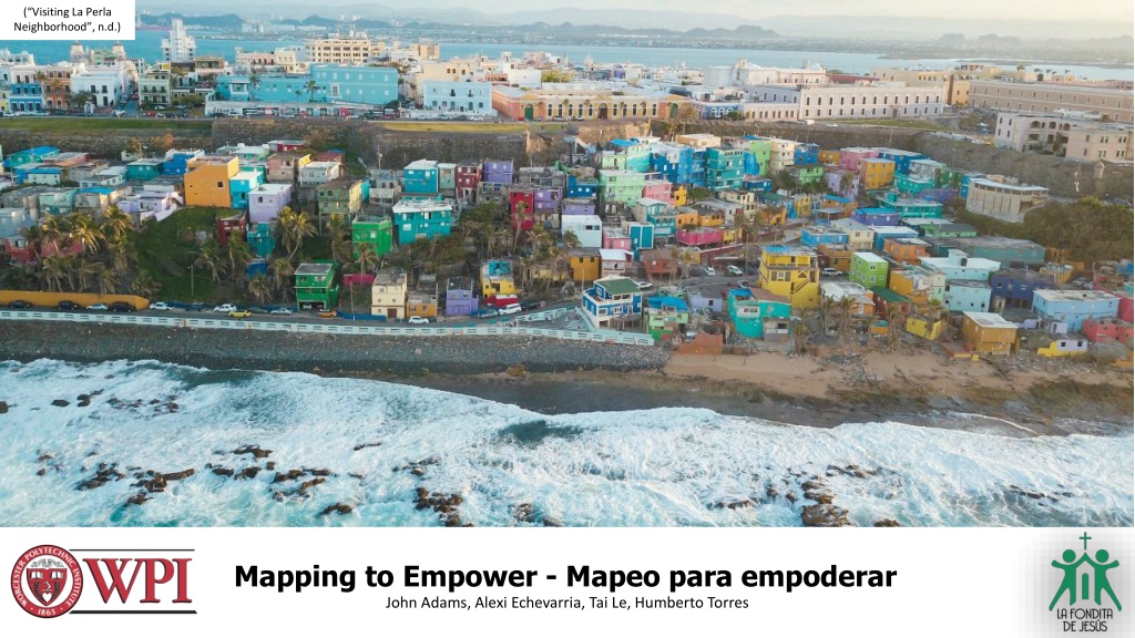
(Visiting La Perla Neighborhood , n.d.) Mapping to Empower - Mapeo para empoderar John Adams, Alexi Echevarria, Tai Le, Humberto Torres
Agenda for Today - Agenda para hoy INTRODUCE OUR TEAM/WPI - PRESENTAR NUESTRO EQUIPO/WPI WHAT HAVE WE BEEN DOING - QU HEMOS ESTADO HACIENDO? WHY MAPPING? - POR QU MAPEAR? 2
Not possible without: Lourdes Diaz Pab n Lourdes Lopez Scott Jiusto Leslie Dodson The entire community of La Perla Our friends and families
WPI Worcester Polytechnic Institute (WPI) has been collaborating with Puerto Rico for more than 30 years, carrying out all kinds of projects to help the communities of the island. This is the first project that students from WPI are working with La Fondita de Jes s and La Perla. We hope that these partnerships continue, and future student groups can further the work we have started.
(Concepcion, 2023) La Perla Through the Years 5
Timeline of La Perla Houses painted in bright colors Founded as a slaughterhouse shanty town "Slum Clearance" attempts to displace residents "Despacito" music video in La Perla Populated mostly by slaves Population dips from 4500 to 1200 Hurricane Maria 18th Century 19th Century 1940s 2010 2015 2017 Present More people began to immigrate from the countryside 2011 - Drug raid displaces 114 residents 3 Sectors General distrust of official governments Stigma grew/formed due to marginalized population Arts to fight for rights ~ 200 Households 6
Our 3 Main Goals 1 2 3 Build Talk Create Build a foundational relationship with La Fondita and La Perla Talk with community members and explore mapping ideas Create maps and guides for mapping software 7
What have we been doing - Qu hemos estado haciendo?
Why Mapping? - Por qu mapear? Visual way to show and represent information - Forma visual de mostrar y representar informaci n Identifies assets in the community - Identifica activos en la comunidad Highlights areas for oppurtunity - reas destacadas para la oportunidad Bring people together - re nen a las personas
(48 Hours in Boston , 2017) https://www.localguidesconnect.com/t5/Travel-and-Advice/48-Hours-in-Boston-with-a-custom-map/m-p/156441
Art & Mural Map - Interactive map that highlights the beaty of La Perla through art, murals, and tourist attractions
Sectors Map Interactive map that highlights the three main sectors of La Perla Lucila Silva Guaipao San Miguel
Evacuation Route Map Interactive map that begins to organize possible driving and walking evacuation routes from different areas in La Perla
Conclusion Training Session 2 Facilitator Guides Journey Book 4 Map Templates
"To work with communities in vulnerable situations is to enter spaces of deep introspection, contemplation, and all of the transformative aspects that facilitate real personal and professional growth." - Lourdes Diaz Pab n, Equity and Social Justice Coordinator, Corporacion La Fondita De Jes s 18
5 10 Minute Break Next Up: Our Google My Map Training Workshop


")