Understanding Latitudes and Longitudes on a Globe
Exploring latitudes and longitudes, this module delves into the concept of latitudes as horizontal lines on a globe, with the Equator dividing the Earth into hemispheres, and longitudes as vertical lines known as Meridians. Learn about the Prime Meridian, time zones, standard time, and more to enhance your understanding of global coordinates and time measurement.

Download Presentation

Please find below an Image/Link to download the presentation.
The content on the website is provided AS IS for your information and personal use only. It may not be sold, licensed, or shared on other websites without obtaining consent from the author. Download presentation by click this link. If you encounter any issues during the download, it is possible that the publisher has removed the file from their server.
E N D
Presentation Transcript
Globe: Latitudes and Longitudes Geography Class-6 Module-2 Module-2 Geography Class-6
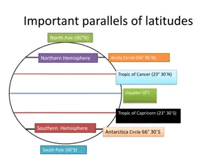
Revision of module 1 Globe is a true model of the Earth. Latitudes are imaginary lines that run horizontally across the Globe. The Equator is of 0 latitude and divides the Earth into the Northern and Southern Hemispheres. Depending on the amount of heat and light received from the sun, the Earth is divided into the Torrid, Temperate and Frigid Zones.
Topics to be covered Longitudes Prime Meridian Grid Longitude and Time Local and Standard time Indian Standard Time(IST) Difference between IST and GMT Answer the following
Longitudes An imaginary lines that runs vertically across the surface of the Earth. These lines also known as the Meridians of longitude. The distance between these lines are measured in degrees of longitude. Each degree is further divided into minutes and minutes into seconds. There are 360 meridians of longitudes.
0longitude The longitude of a place is followed by the letter E for east and W for west The Prime Meridian Passes through Greenwich Divides the Earth into The Eastern and Western Hemispheres
Grid :The pattern of latitudes and longitudes drawn on the Earth to help us to locate places. Longitude and Time: The best means of measuring time is by the movement of the earth, the Moon and the Planets. The Sun regularly rises and sets every day which is the best time keeper throughout the world. In calculating time, there are two important terms, a) local time and b) standard time.
Local Time: The places situated on the same longitude will have the same time which is known as local time. It is calculated by the shadow cast by the Sun.
Standard Time: The local time of a place depends on the meridians of longitude that passes through it. There are several longitudes passing through each and every country. It would be confusion, if each place in the country followed its local time. Therefore, every country chooses a Central Meridian whose local time is accepted across the entire nation. The time of chosen Meridian is called standard time.
Indian Standard Time (IST): In India, there will be a difference of 1 hour and 45 minutes in the local time of Gujarat(west) and Assam(east). Therefore, it is necessary to adopt the local time of some Central Meridian as the standard time for the country. In our country, 82 30 E is taken as the standard meridian . The local time at this meridian is taken as the standard time for the whole nation. It is also known as the Indian Standard Time.
Do you know what is the time difference between IST and GMT? India is located east of Greenwich, IST is five hours and thirty minute ahead of GMT.
Answer the following:- Which is the Standard Meridian of India? What do you mean by Prime Meridian? What do you mean by Grid? Differentiate between latitude and longitude. Activity :- a) Locate 82 30 E longitude on the Indian map. b) Draw a circle . Let the Prime meridian divide it into two equal halves. Color and label the eastern and western hemispheres.


:")
:")