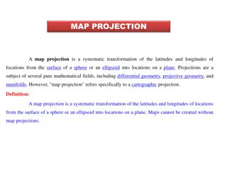
Understanding Map Projections: Types and Applications
Map projection is a systematic transformation of latitudes and longitudes from a curved surface to a flat plane. There are various classifications based on construction methods, tangent surface position, view point of light, and qualities like equal area and equi-distance. Zenithal Polar Equidistanc
0 views • 9 slides
Understanding Latitudes and Longitudes on a Globe
Exploring latitudes and longitudes, this module delves into the concept of latitudes as horizontal lines on a globe, with the Equator dividing the Earth into hemispheres, and longitudes as vertical lines known as Meridians. Learn about the Prime Meridian, time zones, standard time, and more to enhan
0 views • 13 slides
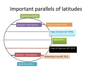
Understanding Earth's Parallels and Meridians: A Geographical Overview
Explore the significance of latitudes and longitudes, including important lines such as the Equator, Tropics, Arctic Circle, Prime Meridian, and International Date Line. Discover the latitudinal and longitudinal extent of India and the location of Delhi Public School in Srinagar. Gain insights into
0 views • 7 slides
Understanding Earth's Geography: A Visual Presentation for Grades IV & V
Explore the wonders of the Earth with this engaging visual presentation designed for grades IV & V. Learn about globes, continents, oceans, important latitudes, longitudes, and key features of the Earth's surface. Discover the North Pole, South Pole, Equator, Northern Hemisphere, Southern Hemisphere
0 views • 14 slides
Understanding Globe: Latitudes and Longitudes in Geography
The globe, a true model of the Earth, represents the planet's shape and features. Learn about latitudes, equator, important parallels, and the heat zones of the Earth. Discover the merits and demerits of using a globe, its different sizes, and uses. Understand how latitudes and longitudes help in lo
0 views • 12 slides

Efficient File Handling Techniques in Python
Explore efficient file handling techniques in Python, such as using 'with' keyword to automatically close files, iterating over lines in a file, splitting lines into fields, and performing operations on CSV files. Learn how to work with a CSV file containing Starbucks data to find the maximum and mi
0 views • 24 slides