Impact of Location, Climate, and Resources on Europe: Case Study of UK
The United Kingdom's location, climate, and natural resources significantly influence where people reside, their livelihoods, and trading activities. The UK, comprising Great Britain and Northern Ireland, benefits from a mild climate due to the Gulf Stream. Its diverse topography, from highlands to
0 views • 20 slides
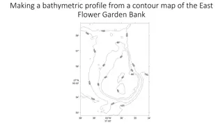
Bathymetric Profiles Using Contour Maps
Learn how to create a bathymetric profile from a contour map of East Flower Garden Bank. By following specific steps and using graph paper, you can analyze the steepness of underwater features such as the bank, distinguishing between gentle and steep slopes based on contour lines' spacing and depths
7 views • 10 slides
Natural Vegetation and Wildlife Sanctuaries in India
The natural vegetation in India varies based on climatic and topographical factors, leading to diverse flora such as Evergreen Rain Forests, Monsoon Deciduous Forests, and Desert ecosystems. The Himalayas showcase vegetation changes with altitude, while factors like soil and topography influence veg
3 views • 39 slides
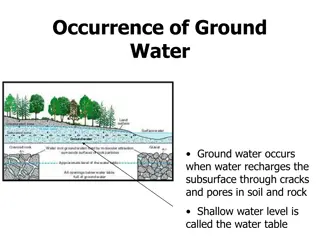
Groundwater: Occurrence, Recharge, and Movement
Groundwater occurs when water seeps into the subsurface through cracks and pores in rocks and soil, forming the water table. Recharge happens naturally through processes like precipitation and snowmelt, as well as artificially through methods like recharge wells and water spread over land. The movem
2 views • 8 slides
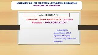
Soil Formation: Factors and Processes Explained
Soil formation is a complex process influenced by factors like parent material, topography, climate, organisms, and time. This article delves into the fundamentals of soil evolution, discussing how soils are formed from weathered rock materials and the role of pedogenesis. Factors affecting soil for
1 views • 28 slides
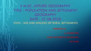
Size and Spacing of Rural Settlements in Geography Research
This presentation delves into the significant influence of size and spacing on the distribution pattern of rural settlements. It explores how factors like population size, areal size, topography, soil fertility, and more impact the density and distribution of settlements, categorizing them based on
3 views • 15 slides
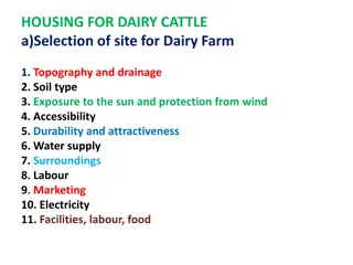
Essential Factors for Selecting a Dairy Cattle Farm Site
Selecting the ideal site for a dairy farm involves considering various factors such as topography, soil type, sun exposure, water supply, accessibility, and more. Understanding the requirements for housing, feeding, and milking facilities is crucial for successful dairy cattle farming.
3 views • 17 slides
Geography and Five Regions of Wisconsin: Key Points and Natural Features
Wisconsin's geography is influenced by the Great Lakes and the Mississippi River, affecting population distribution based on topography, soil, and climate. The state's historical reliance on soil resources for fur trade, lumber, farming, and manufacturing is evident. Varied regions like the Driftles
3 views • 9 slides
City of Signal Hill Stormwater Quality Program Overview
The City of Signal Hill, known for its unique geographic characteristics and historical oil production legacy, is proactive in implementing stormwater quality programs. The city addresses MS4 and TMDL requirements, demonstrating regional leadership in environmental initiatives. With a population of
1 views • 42 slides

CCBC Accessible Housing Service Overview
CCBC Accessible Housing Service in Caerphilly County Borough provides unified housing services catering to various tenures. Challenges include deprivation and topography. The service deals with housing options, strategy, and allocations, focusing on Welsh Housing Quality Standards. Private Sector Ho
0 views • 36 slides

Multibeam Data Analysis for Seabed Characterization at Deception Island, Antarctic
This work explores the morphological and sedimentary characterization of the seabed at Deception Island, Antarctic, through the analysis of multibeam bathymetric data and geological samples. The study identifies ravines, depressions, and volcanic structures as key features, revealing a seabed predom
0 views • 7 slides

Sustainable Development in Ghana: Environmental Challenges and Opportunities
Ghana faces environmental challenges such as erosion, deforestation, and water scarcity, but also has abundant natural resources like gold and oil. The country's diverse climate and topography present both risks and opportunities for sustainable development.
2 views • 13 slides
Root Surface Modifications in Periodontal Therapy
Periodontal therapeutic modalities focus on root surface modifications due to periodontitis, which involves physical, chemical, and cytotoxic changes. Successful outcomes depend on factors like clot stability, cell migration, attachment, proliferation, and debridement. Analyzing cementum properties
0 views • 6 slides
Erosion and Deposition Processes in Geology
Explore the dynamic forces of erosion and deposition in geology, from the constructive and destructive processes to weathering, erosion agents, rates of erosion, sorting of sediment, deposition, and different depositional environments where sediments settle. Delve into how factors like weather, clim
0 views • 12 slides
Hydrographic Surveying in Geomatics Engineering
Hydrographic surveying is a specialized field within geomatics engineering focused on mapping the water floor to produce nautical charts or bathymetric maps. These surveys play a crucial role in navigation, pipeline routing, cable installation, and more, providing essential data for various applicat
0 views • 19 slides

Surgical Needles and Their Uses
Surgical needles come in various shapes and sizes, each designed for specific purposes based on tissue type, wound topography, and needle characteristics. The sharpest needles are made of stainless steel and have tapered points with smooth cutting edges. Eyed needles require threading, creating a la
0 views • 14 slides

High-Resolution 3D Seafloor Topography Enhancement Using Kalman Filtering
Proposing a Kalman Filter approach to refine seafloor topography estimation by integrating various geophysical data types. The method allows for producing regional bathymetry with higher resolution, truncating unnecessary observations, and reducing the matrix dimensions in the inverse problem. Inclu
0 views • 9 slides
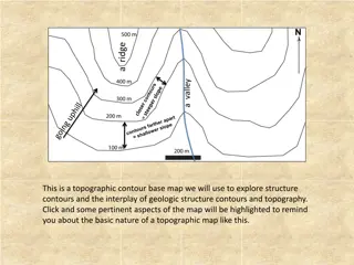
Topographic Contour Maps for Geologic Exploration
A topographic contour base map is a valuable tool for exploring geologic structures and their interplay with topography. By analyzing strike angles, parallel lines, and structure contours, one can determine the orientation, strike, and dip of geologic features. This information can be used to map ou
0 views • 4 slides
Watersheds and Their Importance
A watershed is an essential area of land that directs rainfall and snowmelt to various bodies of water, forming a connected water system. Water in a watershed flows from high points to lower points via rivers, streams, and lakes, eventually reaching the ocean. Watersheds can vary in size and topogra
0 views • 20 slides

FIDOL Factors in Odour Nuisance Evaluation
Factors extracted from a presentation by Marzio Invernizzi and Laura Capelli on odour nuisance include Frequency, Intensity, Duration, Offensiveness, and Location (FIDOL). Frequency of odour exposure is influenced by emission sources, weather conditions, and topography. Intensity is evaluated throug
0 views • 8 slides

Inspiring Educational Berlin Tour for Schools - Equity Adventures
Join Equity for an educational trip to Berlin that offers inspiring learning experiences for young students in years 7 and 8. Explore key historical sites like the Wannsee mansion, Topography of Terror, and Checkpoint Charlie while delving into the rich cultural heritage of the city. With over 80 ye
0 views • 7 slides
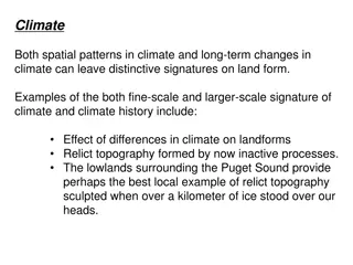
Distinctive Signatures of Climate on Land Form
Climate can leave unique imprints on land forms, both at fine and large scales. Examples include relict topography shaped by past climates and the influence of climate zonation on the Andes' shape. Erosional processes and glacial activities also play significant roles in shaping Earth's surface feat
0 views • 40 slides
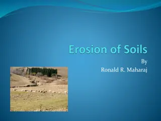
Soil Erosion: Causes, Effects, and Prevention
Soil erosion, the physical removal of topsoil by agents like water, wind, and gravity, poses significant environmental challenges. Erosion affects soil quality, moisture levels, and leads to off-site issues such as sedimentation and pollution. Different types of erosion, including wind, water, and g
0 views • 21 slides
European Union's Copernicus Programme: Eyes on Earth
Copernicus is the European Union's Earth Observation Programme that provides crucial information services through satellite data and in situ observations. The program includes various satellites like Sentinel-1 for all-weather radar imaging, Sentinel-2 for multispectral optical observations, Sentine
0 views • 37 slides
Dating Topography of the Sierra Nevada, California with Apatite (U-Th)/He Ages
Utilizing apatite (U-Th)/He ages, this study explores the topography of the Sierra Nevada in California. By analyzing age variations between ridges and valleys, researchers estimate the timing of incision and total relief of the mountain range. Results suggest minimum age of river incision as 70-80
0 views • 8 slides
Factors Influencing Watershed Management Explained by Mr. Anil Swami
Mr. Anil Swami, an Assistant Professor specializing in Rainfed Agriculture & Watershed Management, discusses the factors affecting watershed management. These factors are categorized into watershed characteristics, climatic characteristics, land use patterns, social status, and organization. Watersh
0 views • 18 slides
Landforms and Topography: An Illustrated Guide
Explore the world of landforms and topography with detailed descriptions and images. Learn about key concepts such as relief, plains, mountain ranges, and plateaus. Understand how elevation, relief, and landforms shape the landscape around us.
0 views • 10 slides
Ocean Surface Topography Science Team Meeting on Precise Orbit Determination
The Ocean Surface Topography Science Team Meeting delved into the precise orbit determination of the Jason-3 satellite, focusing on miscentering observations and the benefits of yaw flips. The meeting discussed previous approaches, the context of the satellite's orientation, goals for monitoring per
0 views • 12 slides
Overview of 2014 NCEP Production Suite Review on Global Modeling
The 2014 NCEP Production Suite Review highlighted the significant implementation of the 13 km Global Forecast System (GFS). This major update involved substantial enhancements in resolution, observations, analysis, and physics, impacting various NCEP models and centers. The improved 13 km GFS brough
0 views • 20 slides
UNESCO Stampriet TBA Project Data Availability Report February 2014
This report by Jürgen Kirchner provides information on the availability of data related to the UNESCO Stampriet TBA project, ranging from physiography and climate to hydrogeological characteristics and socio-economic aspects. It discusses temperature, precipitation, evapotranspiration, land use/lan
0 views • 35 slides

Broadband Array Processing of SH-wave Data Using Superarrays
Broadband array processing of SH-wave data using superarrays at High Lava Plains (HLP) with a flexible array of 118 broadband stations deployed between 2006-2009. The processing involves transverse component displacement seismograms aligned and normalized to unity on direct-S, and Vespagrams analysi
0 views • 15 slides
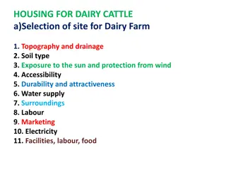
Selecting Ideal Site for Dairy Farm: Key Considerations and Structures
Choosing the right site for a dairy farm involves assessing factors like topography, soil type, sun exposure, and more. Understanding housing requirements, such as space for cattle and essential structures like milking barns, calving pens, and isolation sheds, is crucial for efficient dairy farming
0 views • 17 slides
Soil Erosion: Causes, Types, and Prevention
Soil erosion is a significant environmental issue with detrimental impacts such as topsoil loss, nutrient depletion, increased costs, and pollution. This article delves into the types of erosion - including sheet, rill, gully, and stream bank erosion - highlighting their characteristics and effects.
0 views • 18 slides
Challenges and Solutions for Electrification in Off-Grid Areas of Myanmar
Myanmar is in the midst of a significant policy transformation to enhance development across all sectors, including energy. The country aims to increase electrification from 30% to 100% by 2030, facing challenges due to its vast off-grid areas and economic feasibility issues. Implementing proper pla
0 views • 17 slides
Location and Topography of Pakistan: A Comprehensive Overview
Pakistan's geographical location in South Asia, surrounded by China, India, Afghanistan, and Iran, with diverse landforms and physical features. Detailed information on its latitude, longitude, area, coastline, highest and lowest points, and importance as the "Gate Way To Central Asia.
0 views • 22 slides
Ice Flow and Glacial Processes in Landscapes
Delve into the intricate world of ice flow and glacial processes, exploring topics such as the movement of ice sheets, effects of glacial erosion on topography, basal melt in ice sheets, and the formation of eskers. Discover the reasons behind U-shaped glacier-carved valleys, the role of water table
0 views • 40 slides

Nguyen Manh Duong: Maritime Safety Professional Achievements
Nguyen Manh Duong, a maritime safety professional from Vietnam, has a strong career background in aids to navigation management, inspection of nautical charts, and issuance of Notices to Mariners. His achievements include completing various training programs in technical aspects of maritime boundari
0 views • 8 slides
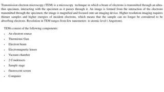
Transmission Electron Microscopy (TEM)
Transmission Electron Microscopy (TEM) is a powerful microscopy technique that uses a beam of electrons to create high-resolution images of ultra-thin specimens. It provides detailed information on topography, morphology, composition, and crystalline structure. Sample preparation for TEM is crucial,
0 views • 10 slides
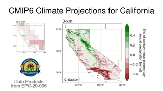
Climate Projections and Data Evaluation for California
Detailed information on CMIP6 climate projections for California, evaluation of global climate models, summaries of data on the C-DAWG website, large set of CMIP6 downscaled climate projection data, and improvements in the LOCA2-Hybrid approach. The LOCA2-Hybrid method offers higher resolution train
0 views • 15 slides

Stick Diagrams in VLSI Circuit Design
Stick diagrams in VLSI design help visualize the layout of components on silicon by capturing topography and layer information through color codes or monochrome encoding. They serve as an interface between symbolic circuits and actual layouts, facilitating the planning of layout and routing while de
0 views • 27 slides