Mastering Surveying with Prismatic Compass
Learn the art of determining positions on Earth's surface using a prismatic compass. Explore its parts, functions, and application in surveying, enabling precise measurements and mapping. Enhance your skills in angular and linear distance measurements with this comprehensive guide.
2 views • 21 slides

Prismatic Compass Survey: A Comprehensive Guide
A prismatic compass is a vital tool in surveying, used to determine bearings, traverse lines, and included angles. This guide covers the principles of compass surveying, the components needed, and the method of compass traversing. Detailed images showcase the prismatic compass, its stand, measuring
0 views • 11 slides

Understanding the Basic Principles of Surveying for Building and Structural Projects
Surveying plays a crucial role in ensuring accurate positioning and alignment of structures such as buildings, bridges, and roads. This article delves into the definition of surveying, stages in the surveying process including reconnaissance, field work and measurement, and office work. Understandin
1 views • 60 slides

Electromagnetic Surveying Methods and Applications
Electromagnetic surveying, conducted by Dr. Laurent Marescot, utilizes various methods like resistivity, induced polarization, and high-frequency techniques for exploration and investigation purposes. The electromagnetic method involves generating primary fields and detecting secondary fields to ana
2 views • 55 slides

How to get free solar panels from the government 2024 in Massachusetts USA ?
NES G or New England Solar and Green Inc. evolved from Guntlow & Associates, Inc. where for almost 30 years we have been providing engineering and design services in the building industry.\nBest Solar Power Panels,G&A was established in 1989 by Vincent Guntlow, a professional civil engineer who is r
4 views • 15 slides

Aeolian Landforms: Shaping Earth's Surface Through Wind Action
Geomorphic processes, including aeolian processes, play a significant role in modifying the earth's surface. This article delves into how wind erosion and deposition create unique landforms such as ventifacts and yardangs. Understanding the transportation methods and topographic effects of wind eros
0 views • 22 slides
Engineering Considerations in Applied Geomorphology and Land Use Planning
Engineering works in geomorphology and land use planning involve evaluating geologic factors for projects like road construction in varied terrains such as karst regions, glacial terrains, and areas with considerable relief. Factors like soil composition, drainage, and topographic conditions play cr
2 views • 24 slides
Geodetic Surveying and Triangulation System Overview
Geodetic surveying involves determining precise positions on the Earth's surface, while triangulation is a method that uses interconnected triangles for accurate measurements. The principles of the triangulation system aim to establish horizontal points for various surveys and assist in determining
2 views • 23 slides

Reliable Land Survey Services in Ontario
Konanorth.com offers precise and trustworthy land surveying services in Ontario. For all of your surveying requirements, put your trust in our knowledge and accuracy.\n\n\/\/ \/construction-survey-layouts
5 views • 1 slides

Effective Study Methods: SQ3R Reading Technique by Modibo SANGARE, M.D., Ph.D.
SQ3R method, introduced by Francis Robinson, emphasizes Survey, Question, Read, Recite, and Review steps for effective reading. This method advocates careful surveying before reading, questioning while surveying, and active reading techniques to enhance comprehension. It focuses on structured readin
0 views • 28 slides
Understanding Chain Surveying: Principles and Operations
Chain surveying is a method used for small, flat areas while traversing is preferred for larger, undulated terrains. Principles involve dividing areas into triangles for accurate plotting, with well-conditioned triangles being ideal. Operations such as chaining, ranging, and offsetting are essential
2 views • 23 slides
Understanding the Essentials of Surveying Classification
Surveying is the art and science of determining relative positions on the earth's surface. This presentation delves into why classification of surveying is crucial, discussing the various parts of classification based on instruments, methods, purposes, and nature of the field. Through categorization
4 views • 53 slides
Understanding Cadastral Mapping Components and Data Sources
Cadastral mapping involves geodetic control networks, parcel identification, and various overlays like zoning and floodplains. City maps are categorized into base, derived, and thematic maps. Data sources include spatial and non-spatial data for property assessment. Layers in cadastral maps cover to
1 views • 16 slides
Understanding Differential Leveling in Surveying
Differential leveling is a crucial aspect of surveying that involves determining the elevation of points with respect to a reference datum. This process includes various key elements such as benchmark, back sight, fore sight, and change points. By utilizing methods like the Height of Instrument and
1 views • 12 slides
Understanding Cadastre and Cadastral Surveying
Cadastre is a system containing land information, while cadastral surveying involves defining property boundaries and land ownership rights. Cadastral surveys subdivide land parcels for ownership and document property ownership with geometric descriptions. Real property ownership denotes the authori
2 views • 17 slides

Understanding Contour Surveying in Land Assessment
Contour surveying involves determining the elevation of points on the ground to create contour maps, aiding in land assessment and design work. The process includes defining contour lines, establishing vertical and horizontal controls, determining contour intervals, and employing methods for surveyi
2 views • 19 slides

Insights into ePlan Implementation and Collaboration in Surveying Expo 2016
In Surveying Expo 2016, discussions revolved around common issues with Plans of Subdivision, ePlan updates, Subdivision Branch status focusing on retirement of Neil Coupar, and ePlan implementation progress since May 2013. Additionally, a collaborative project with the University of Melbourne aimed
1 views • 30 slides
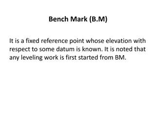
Understanding Bench Marks in Surveying
Bench Marks (B.M) serve as fixed reference points with known elevations, essential for starting any leveling work. They can be categorized into GTS, Permanent, Temporary, and Arbitrary types, each serving specific purposes in surveying projects.
1 views • 8 slides
Understanding Surveying Principles and Instruments
Surveying involves determining and recording earth features' relative positions, utilizing instruments like total stations, digital levels, and GPS for linear, angular, and height measurements. Different types of surveys include traverse, triangulation, and plane table. Advantages of digital levels
5 views • 26 slides
Study Guide for Surveying and Leveling Course
This study guide provides an overview of topics covered in a Surveying and Geomatics course, including definitions, instruments, ranging methods, scales, and verniers. It delves into the art and science of surveying for determining positions on Earth's surface, as well as the principles and practice
0 views • 9 slides

Understanding Electronic Distance Measurement in Surveying
Electronic Distance Measurement (EDM) is a precise method for measuring distances between two points using electromagnetic waves. It offers speed and accuracy, especially useful for long or inaccessible distances. EDM, a type of surveying instrument, measures phase changes in energy waves traveling
0 views • 7 slides

Introduction to Plane Table Surveying in Civil Engineering
Plane table surveying is a graphical and cost-effective method used for surveying small-scale areas. This method involves simultaneous plotting of the survey while in the field, ensuring accuracy and efficiency. Key principles, instruments, setting up procedures, advantages, disadvantages, and commo
1 views • 37 slides

Understanding Surveying Fundamentals
Learn the basic definitions of surveying, including concepts like plan transformation, map representation, angles, and the shape of the Earth's surface. Explore terms such as spheroid, meridian, horizontal plane, vertical line, and more.
0 views • 17 slides

Evolution of Geomagnetic Methods in Applied Geophysics and Their Diverse Applications
Explore the rich history of geomagnetic methods from ancient Chinese lodestone use to modern magnetic surveying technologies. Learn about the principles of magnetics surveying, applications in locating metal objects, mapping near-surface features, mineral exploration, and geological bedrock mapping.
9 views • 36 slides

Understanding Land Records and Surveying Practices
Explore topics such as re-locating section corners, working with corner data in GIS, and the importance of accurate survey control in managing GIS systems. Learn about the challenges surveyors face in maintaining section corners and the significance of finding original markers. Discover educational
0 views • 17 slides
Urban Poor Basic Sanitation Site Surveying Guidelines
Guidelines for conducting a site survey in urban areas to prepare the final design for basic sanitation facilities for the urban poor. The process involves site selection, surveying techniques, and data collection methods, including boundary marking, raster leveling, module arrangement, and levellin
0 views • 13 slides
Understanding Hydrographic Surveying in Geomatics Engineering
Hydrographic surveying is a specialized field within geomatics engineering focused on mapping the water floor to produce nautical charts or bathymetric maps. These surveys play a crucial role in navigation, pipeline routing, cable installation, and more, providing essential data for various applicat
0 views • 19 slides
Overview of Compass Surveying and Prismatic Compass in Engineering Technology Research
Explore the world of compass surveying and the prismatic compass in engineering technology research. Learn about the instruments used, principles of surveying, and the parts of a prismatic compass. Discover how these tools are essential for area calculation and accurate measurements in various engin
0 views • 22 slides
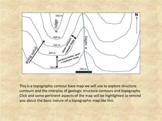
Understanding Topographic Contour Maps for Geologic Exploration
A topographic contour base map is a valuable tool for exploring geologic structures and their interplay with topography. By analyzing strike angles, parallel lines, and structure contours, one can determine the orientation, strike, and dip of geologic features. This information can be used to map ou
0 views • 4 slides

High-Tech Survey Methods for Continuous Cadastral Map Generation
Generation of cadastral maps through advanced survey techniques using ortho-images, DGPS/GNSS, and ETS. The process involves obtaining boundary vectors from ortho-images, surveying obscured areas with DGPS/GNSS and ETS, and integrating datasets in a GIS environment. The objective is to create contin
0 views • 14 slides
Basics of Compass Surveying and Magnetic Bearings
Compass surveying involves the use of compasses to determine directions and bearings during surveying activities. This method utilizes tools like prismatic compasses and magnetic needles to establish true and magnetic meridians, as well as arbitrary and grid meridians. Understanding concepts like wh
0 views • 17 slides
Estimation and Quantity Surveying Presentation by Prof. Balraj Marjara
This presentation covers topics related to estimation and quantity surveying, including brief and detailed specifications, rate analysis, materials, surface preparation, mortar and bedding, white glazed tiles, and more. It provides detailed guidelines for laying tiles, preparing surfaces, and choosi
0 views • 7 slides
WASHINGTON SURVEYING AND RATING BUREAU - Fire Protection Grading and Evaluation
The Washington Surveying and Rating Bureau assigns Protection Class gradings to communities based on fire protection capabilities, influencing insurance pricing. The evaluation covers water supplies, fire department services, emergency communications, and more. Detailed assessments of current and ne
0 views • 13 slides
Understanding Cut Slope Design and Topographic Surveying
Geotechnical engineers and engineering geologists play crucial roles in designing earth structures based on geological data. This involves assessing and forecasting hazards, making slope design recommendations, and more. The process includes topographic surveys, rock mass characterization, photogram
0 views • 11 slides

Understanding Topographic Maps and Watersheds
Exploring the concept of watersheds and learning how to read topographic maps through questions and diagrams. Understand the elevation, steepness, and heights of hills A and B. Enhance knowledge on contour lines and their significance in identifying terrain features. Practical exercises for better c
0 views • 5 slides

Understanding Push-to-Web and Address-Based Online Surveying
Push-to-web surveying entails contacting samples offline and prompting them to complete online questionnaires, capitalizing on cost efficiency, convenience, and modern design elements. Various push-to-web designs employ different contact approaches, incorporating multiple reminders for optimal respo
0 views • 27 slides

On-Site Conveyor Surveying and Parts Auditing Program
Enhance the efficiency of your Dorner conveyor system with the Parts Auditing and On-Site Conveyor Surveying Program. Expert technicians conduct thorough surveys to recommend necessary spare parts and maintenance, reducing downtime and maximizing productivity. Qualify for free preventative maintenan
0 views • 5 slides
Quantity Surveying for Concrete Works: Blinding and Foundation Estimates
This course covers quantity surveying techniques for blinding concrete under foundations and estimating concrete needed for various structural elements like foundations, columns, and walls. Dr. Ala'a Alshdiefat provides detailed calculations and examples for calculating blinding concrete and foundat
0 views • 25 slides

Hydrographic Surveying in Saint Vincent and the Grenadines
Saint Vincent and the Grenadines face challenges in hydrographic surveying due to lack of trained personnel, equipment, and compliance with international obligations. Efforts are being made through regional projects to develop hydrographic services and improve nautical chart production.
0 views • 10 slides

The Importance of Women Empowerment in Engineering and Surveying Industries
Women power is crucial for the success of the NEB as it addresses prevalent issues such as gender stereotypes, salary gaps, and lack of role models in engineering and surveying fields. Initiatives like the CLGE Women in Surveying project aim to empower women through education, entrepreneurship, and
0 views • 14 slides