Understanding Topographic Maps and Watersheds
Exploring the concept of watersheds and learning how to read topographic maps through questions and diagrams. Understand the elevation, steepness, and heights of hills A and B. Enhance knowledge on contour lines and their significance in identifying terrain features. Practical exercises for better comprehension provided.
Uploaded on Sep 22, 2024 | 0 Views
Download Presentation

Please find below an Image/Link to download the presentation.
The content on the website is provided AS IS for your information and personal use only. It may not be sold, licensed, or shared on other websites without obtaining consent from the author. Download presentation by click this link. If you encounter any issues during the download, it is possible that the publisher has removed the file from their server.
E N D
Presentation Transcript
WHAT IS A WATERSHED
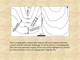
Answer the questions about the How to Read a Topographic Map diagram 1. Which is higher, hill A or hill B? _____________________________________________ 2. Which is steeper, hill A or hill B? ____________________________________________ 3. How many feet of elevation are there between contour lines? ____________________ 4. How high is hill A? __________________ Hill B? _______________________ Answer the questions about the How to Read Topographic Map diagram 1. Which is higher, hill A or hill B? Hill B 2. Which is steeper, hill A or hill B? Hill B Remind team mates that the closer the contour lines, the more steep the hill. DO: Have students identify on the map where the steepest slopes are? Ask students why this information may be helpful when going hiking. 3. How many feet of elevation are there between contour lines? 10 feet, do the exercise below. DO: The line on the map are contour line. Ask team mates to trace with their fingers around the 40-foot contour line on the map. Then ask them to look at the picture of the hill and draw their fingers around the 40-foot contour line. Do the same thing for the 20-foot line. Each contour line is 10 feet apart. 4. How high is hill A? __~ 42 feet_________ Hill B? __~ 54 feet______________
