
Alameda Hospital Seismic Planning and Financial Committee Meeting Summary
The Alameda Hospital Seismic Planning and Finance Committee met to review capital cost estimates, consider various seismic options, and assess financial projections. The Joint Planning Committee (JPC) collaborated to evaluate maintaining the current footprint, reconfiguring the hospital, and optimiz
0 views • 23 slides
Relational Database Design and Mapping Techniques
Explore the process of mapping Entity-Relationship (ER) and Enhanced Entity-Relationship (EER) models to relational databases. Learn about relational model concepts, mapping algorithms, and the goals and steps involved in the mapping process. Discover how to preserve information, maintain constraint
3 views • 42 slides
Enhancing Geotechnical Investigation Methods in Ghana for Foundation Design of Large Structures
Enhancing the standard of geotechnical investigation field testing in Ghana is crucial to ensure appropriate use of equipment like DCP for designing foundations of large structures. Objectives include assessing site suitability, obtaining design inputs, anticipating construction challenges, and esti
0 views • 31 slides
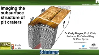
Subsurface Structures of Pit Craters Through Seismic Reflection
Discover the technique of seismic reflection imaging to unveil the subsurface structures of pit craters on Earth and Mars. Follow the analysis of seismic data to map pit craters and their connections to geological features like dykes and fault jogs, shedding light on the formation processes of these
1 views • 11 slides

Mapping Robot using ROS, Lidar with Raspberry Pi & MATLAB
Turtle.bot is a popular product for home service robots, utilizing SLAM and navigation technologies. It features gyro, Kinect sensors, Lidar, and a laptop for mapping. The robot localizes and navigates using ROS in Raspberry Pi connected with MATLAB. ROS (Robot Operating System) is a set of software
0 views • 17 slides
National Labor Mapping Application User Roles and Access Overview
This detailed overview outlines the implementation plan, user roles, and access benefits of the National Labor Mapping Application. Users are assigned specific roles with established access through domain usernames, enhancing security measures. Different user roles such as VISN Coordinators, Site Te
1 views • 14 slides
Integrated Reservoir Characterization in Semliki Basin, Albertine Graben
Quantitative reservoir characterization using rock physics, seismic, and geological constraints is crucial for hydrocarbon prospect evaluation. This study by Nakajigo Joan explores the integration of these disciplines in the Semliki Basin to improve reservoir property delineation and reduce uncertai
0 views • 24 slides

Mapping Methodology for Establishing ESCO Relations
Learn how to set up teams, collect resources, compare classifications, and establish mapping relations for ESCO implementation projects. Get insights on using computer-assisted suggestions, updating mapping tables, and selecting mapping projects. Explore techniques for navigating classifications, br
1 views • 21 slides
Seismic Source Parameters in Earthquake Dynamics
The seismic source parameters in earthquake dynamics involve describing a fault as a discontinuity causing displacements, requiring a complex treatment of forces. The Earth's equilibrium necessitates a specific system of forces to explain displacements along faults. The seismic moment tensor, consis
4 views • 32 slides
Texture Mapping in Computer Graphics
Delve into the world of texture mapping as a solution to the smoothness of polygons in computer graphics. Learn how to create textured scenes using techniques such as bump mapping and environmental mapping. Discover the process of representing textures, working with curved surfaces, and mapping onto
2 views • 24 slides
Introduction to Data Analysis in Geophysics with Seismic Analysis Code - SAC Lab 2.1
Explore the world of geophysics data analysis using the SAC Lab 2.1 code. Learn about seismic analysis, Fourier transform analysis, spectral analysis, color tracing, integration, differentiation, and more. The SAC online documentation provides valuable resources for users to delve deeper into this f
0 views • 45 slides

Innovative LiDAR Cave Mapper for Cavers
Develop a portable and cost-effective LiDAR cave mapper to assist freelance cavers in mapping caves efficiently. The project aims to create a device that is affordable, DIY-style, and open-source, making cave mapping more accessible and accurate. The team from FAMU-FSU College of Engineering strives
0 views • 22 slides
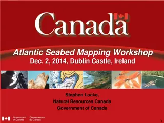
Atlantic Seabed Mapping Workshop Summary
Workshop held in Dublin Castle on Dec 2, 2014, discussed current and future plans for seabed mapping in the Atlantic. Key topics included navigational charting, initiatives by various organizations, challenges of disjointed mapping efforts, and proposed actions to address issues. Recommendations inc
1 views • 5 slides
Career Path Presentation of Christopher Madugo at Pacific Gas and Electric
Christopher Madugo's career path at Pacific Gas and Electric involves a strong focus on seismic hazard assessment for utility infrastructure. With expertise in fault characterization and geohazard sensitivity, he has contributed significantly to projects like the Panama Canal Expansion. In-house at
0 views • 12 slides
Determining OBS Clock Drift Using Seismic Interferometry
Determining clock errors in Ocean Bottom Seismometers (OBSs) is crucial for accurate seismic data recording. This study presents a method using ambient seismic noise and seismic interferometry to correct clock drift in OBSs. The program developed employs Python/Fortran to analyze seismic data direct
0 views • 10 slides
Surface Wave Dispersion in Seismic Exploration
Surface wave dispersion, explored by James Crane and Bolu Owolana, plays a crucial role in seismic studies. This phenomenon, involving waves spreading at varying speeds, helps evaluate subsurface characteristics based on wavelength. By studying surface waves, researchers can determine velocity, dens
0 views • 14 slides
Federation of Digital Broad-Band Seismograph Networks: Advancing Global Seismic Monitoring
The Federation of Digital Broad-Band Seismograph Networks (FDSN) was established in 1985 to enhance seismic monitoring capabilities worldwide. FDSN collaborates with national institutions, coordinates new station locations, and promotes standardization of seismic instruments. Despite lacking inter-g
0 views • 21 slides
Federation of Digital Broad-Band Seismograph Networks (FDSN) Overview
FDSN, founded in 1985, coordinates digital broad-band seismic networks globally to enhance seismic monitoring and research. It promotes site selection, data exchange, and instrument standardization, facilitating the installation of seismic stations across various scales to support earthquake studies
0 views • 15 slides
Seismic Site Characterization in Metropolitan Vancouver
The Greater Vancouver area faces high seismic risk due to its population density and critical infrastructure. Ground shaking during large earthquakes depends on various factors including the earthquake source, material properties, and site conditions. Efforts are being made to map seismic hazards, u
0 views • 13 slides
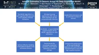
Azimuth Estimation in Seismic Arrays via Deep Augmented MUSIC
This study introduces DA-MUSIC, a hybrid approach combining traditional MUSIC algorithm with deep learning for robust Direction of Arrival (DOA) estimation in seismic arrays. The methodology improves resolution and handles broadband signals effectively. Utilizing non-synthetic seismic data collected
0 views • 4 slides
Leveraging Open Data for Global Seismic Discoveries
Geophysicists Woodward and Hafner highlight the transformative power of open data from distributed geophysical networks, emphasizing its role in advancing scientific research, enhancing operational capabilities, and contributing to the mission of ending nuclear explosions. They underscore the value
0 views • 9 slides
Evaluation of Dynamic Properties and Seismic Performance of Reinforced Ground Using Renewable Materials
Improvement of seismic performance through improved dynamic properties of ground using renewable materials like cement and biopolymer is crucial for reducing earthquake-induced structural damage. This study conducted resonant column tests to assess the enhanced dynamic properties of soil and utilize
0 views • 9 slides
Engineering Seismology & Seismic Hazard Assessment Lectures Overview
This content provides detailed information on the Rose School Lectures 2013 by Sinan Akkar and D. M. Boore focusing on Engineering Seismology & Seismic Hazard Assessment. It includes course schedules, instructor details, contact information, and online software used. Topics covered range from hazard
0 views • 10 slides
Power Mapping: A Visual Tool for Advocates to Influence Change
Power mapping is a visual tool used by advocates to identify key individuals to target in order to effect change. It involves mapping the community around an issue or campaign, identifying decision-makers, adversaries, and influential stakeholders. By following important steps and asking relevant qu
0 views • 10 slides

Enhanced Algorithm for Internal Multiple Attenuation in Seismic Imaging
This research discusses the development of an improved algorithm for internal multiple attenuation in seismic imaging. The focus is on addressing the challenges in onshore and offshore regions close to a 1-D earth model. The algorithm aims to enhance the efficiency and accuracy of data processing in
0 views • 61 slides

Comprehensive Integration of 4D Seismic & Production Data for Norne Reservoir Management
This presentation by Nan Cheng of Statoil in 2013 focuses on the integration of 4D seismic and production data for reservoir management at the Norne Oil Field in Norway. Covering topics such as field structure, zones, official reserves, production profiles, and subsea development solutions, it provi
0 views • 17 slides
GEBCO Technical Sub-Commission on Ocean Mapping (TSCOM) Overview
Technical Sub-Commission on Ocean Mapping (TSCOM) is a key component of the GEBCO program, established in 2006 to provide expertise in seafloor mapping and discuss emerging technologies. TSCOM serves as an authoritative source for bathymetric and hydrographic data and offers ongoing advice to associ
0 views • 12 slides
Virtual Network Mapping: A Graph Pattern Matching Approach
Virtual Network Mapping (VNM) involves deploying virtual network requests in data center networks in response to real-time demands. It facilitates the deployment of virtual networks on physical machines by mapping virtual nodes and links onto substrate nodes and paths, ensuring constraints are met.
0 views • 15 slides
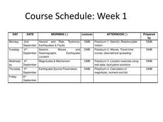
Earthquake and Hazard Assessment Course Schedule
This course covers a comprehensive study on earthquakes, faults, ground motions, seismic assessments, hazard maps, and more. Week by week lectures, practical sessions, and examinations are planned to provide in-depth knowledge on seismic activities and their impacts.
0 views • 4 slides
Innovative Seismic Software and Services for Geophysics Applications
Celebrating 20 years of providing seismic software, dataloggers, and sensors, this company was founded by the original IRIS PASSCAL programming team. With expertise in micro-seismic monitoring and a focus on wide-band, low-power, and portable solutions, they offer sensors with various specifications
0 views • 5 slides
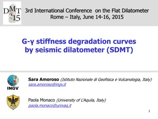
Insights into Soil Stiffness Degradation Using Seismic Dilatometer Data
This content discusses the analysis of soil stiffness degradation curves using data collected from the Flat Dilatometer and Seismic Dilatometer tests. Researchers Sara Amoroso and Paola Monaco present methods for deriving in situ G- decay curves and evaluating shear strain data in various soil types
0 views • 18 slides
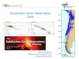
Monitoring Chile's Geological and Volcanic Activity: Subduction Zone Observatory and IPOC Network
Chile's Subduction Zone Observatory, led by Sergio Barrientos at the National Seismological Center, University of Chile, focuses on observing seismic and geological events with cutting-edge technology and networks. The IPOC Chile Volcanological Network monitors around 40 volcanoes, utilizing various
0 views • 4 slides
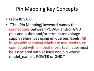
Pin Mapping and Interconnect in IBIS 6.0
Pin Mapping in IBIS 6.0 defines the connections between POWER/GND pins and buffer/terminator voltage supplies using unique bus labels. Interconnects between VDD pins and buffer supply terminals are crucial, with all pins associated with a named supply being shorted together. Draft 9 Interconnects an
0 views • 6 slides
Mercator Mapping: A Key Tool for Information System Management
Mercator is a web application designed for managing the mapping of an organization's information system, allowing for a comprehensive representation of its components and connections with the outside world. Mapping is crucial for controlling, protecting, and defending the information system, as well
0 views • 21 slides
Aging Infrastructure & Seismic Improvements Project Overview
The project application for approval outlines the need for aging infrastructure and seismic improvements, utilizing the GC/CM contracting procedure. The initiative involves funding aspects, project scheduling complexities, team management details, and the rationale behind choosing GC/CM for the proj
0 views • 15 slides
Evaluation of Rock Permeability Variations Using Seismic Velocity Changes
Assessment of fractured rock permeability variations through seismic velocity changes using a coupled simulation of flow, mechanics, and fracture. The study discusses motivation, problem statement, challenges, existing approaches, advantages of the proposed approach, state-of-the-art, mathematical a
0 views • 27 slides
Enhancing Curriculum Development through Mapping for Schools
Curriculum mapping in schools involves using electronic tools to input, track, and analyze data related to curriculum, enabling stakeholders to meet standards, align content, collect real-time data on instruction, and reflect on practices for continuous improvement. Software programs like Rubicon At
1 views • 15 slides
Enhancing Disaster Preparedness with Indonesia's Seismic Monitoring Network
Indonesia's Digital Seismic Network, operated by the Indonesian Agency for Meteorology, Climatology, and Geophysics (BMKG), comprises 164 stations strategically located across the country. The network provides critical seismic data for the Seismic Integration System of InaTEWS, supporting real-time
0 views • 11 slides
Importance of Maps and GIS in Census Mapping: A Case Study from Nepal
Census mapping plays a crucial role in ensuring accurate population counts and territorial delineation. This case study from Nepal highlights the significance of Geographic Information Systems (GIS) in producing high-quality maps for census operations, data collection, analysis, and dissemination. T
0 views • 12 slides
Reservoir Modeling Using Gaussian Mixture Models
In the field of reservoir modeling, Gaussian mixture models offer a powerful approach to estimating rock properties such as porosity, sand/clay content, and saturations using seismic data. This analytical solution of the Bayesian linear inverse problem provides insights into modeling reservoir prope
0 views • 10 slides