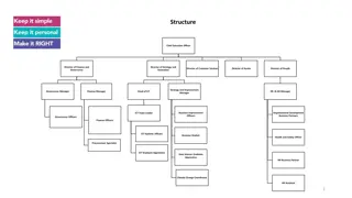
Organizational Structure and Roles within the Company
The organizational structure comprises various positions such as Chief Executive Officer, Directors of Finance, Strategy, Innovation, Customer Services, Assets, and People, along with Managers, Officers, Specialists, and Apprentices in different departments. Regional Managers, Neighbourhood Officers
6 views • 5 slides
Critical Areas in Washington State: Planning, Designation, and Protection
Critical areas in Washington State, including wetlands, aquifer recharge areas, fish and wildlife habitats, frequently flooded areas, and geologically hazardous areas, are defined and protected to safeguard important ecological functions and values. The designation and protection of these areas invo
6 views • 21 slides
NIFA Competitive Programs for Insular Areas
NIFA provides competitive grant programs to support agricultural research, education, and extension in insular areas. These programs cover a wide range of topics, including advanced technologies, food science, animals, environment, international engagement, and human sciences. Eligible institutions
4 views • 13 slides
Guide to Ordering and Downloading VIIRS L2 Data Files from NOAA CLASS
Learn how to order and download VIIRS L2 data files from NOAA CLASS. Register with CLASS, search for datasets, select geographic areas and date/time periods, choose VIIRS products, and place your order using step-by-step instructions provided in the guide.
1 views • 14 slides
Establishing Safety Standards in Non-Movement Areas at Smith Reynolds Airport
This guide outlines the purpose, definitions, rules, and safety measures for operating vehicles in non-movement areas at Smith Reynolds Airport. It emphasizes standardized ground movement practices to ensure the safety of airport patrons, reduce the risk of injury, and maintain a high level of safet
2 views • 12 slides

Evolution of Data Processing Systems in Geographic Information Science
Data processing systems in Geographic Information Science have evolved from manual, analogue methods to advanced software and hardware components. The incorporation of Geographic Information Systems (GIS) has revolutionized the handling and analysis of geo-referenced data, making tasks like data cap
3 views • 20 slides
Geographic Objects in GIS
Geographic objects play a crucial role in GIS by being easily distinguished and named based on parameters like location, shape, size, and orientation. These objects are studied collectively to understand their interactions and relationships, aiding in tasks such as navigation systems and route optim
5 views • 13 slides

Geographic Information System in Sud Nouvelle Calédonie
The province of Sud Nouvelle Calédonie utilizes an open-source-based Geographic Information System (GIS) to serve its territorial administration, with a focus on applications such as land administration, environment, agriculture, and urban planning. The system is supported by a team of engineers, g
0 views • 15 slides
GIS Application for EPC Asset Damage Assessment post-2009 Tsunami
Utilizing Geographic Information Systems (GIS) for assessing damage to EPC assets after the 2009 Tsunami event. Explore worst-hit and affected areas, query assets, evaluate damage, and derive secondary results for the National Emergency Operations Center (NEOC).
0 views • 8 slides

2nd Grade National Geographic: Weather, Tools, and Natural Disasters
Dive into the fascinating world of weather phenomena with 2nd-grade National Geographic resources. From predicting weather using clouds to learning about thunderstorms, hurricanes, and tornadoes, this educational journey also covers weather tools and being prepared for natural disasters.
0 views • 15 slides
Areas of Distinction in Medical Education at RowanSOM
Areas of Distinction (AoDs) at RowanSOM are specialized curricular components that enhance a student's education and competence in various disciplines. These areas of interest do not appear on transcripts but are recognized in residency applications. Students must demonstrate dedication by completin
1 views • 13 slides
what is Geographic Tongue and how does it look
Geographical tongue is an non-contagious condition that provides an atypical, map-like structure to the tongue. A detailed note on this problem is given here. For More Info Visit: \/\/ \/what-is-geographic-tongue\/
0 views • 11 slides

what is Geographic Tongue and how does it look
Geographical tongue is an non-contagious condition that provides an atypical, map-like structure to the tongue. A detailed note on this problem is given here. For More Info Visit: \/\/ \/what-is-geographic-tongue\/
0 views • 11 slides
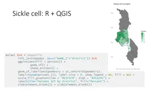
Geographic Data Visualization in R and QGIS for Malawi Health Analysis
Utilizing R and QGIS, this project focuses on visualizing sickle cell and HIV percentages by district in Malawi, mapping health facility locations, creating Voronoi polygons, and displaying malaria cumulative incidence data. Various geographic data visualization techniques are applied to provide ins
0 views • 8 slides
Comparison of Metadata Standards: FGDC, ISO, and NAP
Explore the differences and commonalities between the Federal Geographic Data Committee (FGDC), International Organization for Standardization (ISO), and North American Profile (NAP) metadata standards. Discover the evolution, mandatory elements, code lists, and focus areas in these standards to bet
0 views • 14 slides
Integrating Geographic Data with BI Dashboards for Strategic Insights
Explore the transformative potential of integrating geographic data into BI dashboard tool for strategic insights in our latest blog. Dive deep into the process\u2014from defining precise objectives and meticulous data collection to expert dashboard
0 views • 13 slides
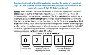
Geographic Distribution Using 3-Digit ZIP Codes
Massachusetts has approximately 685 5-digit ZIP codes assigned by the USPS, which can be aggregated into 18 3-digit ZIP codes for geographic analysis. The distribution of Emergency Department visit volumes varies across these 3-digit ZIP code boundaries, reflecting different regional characteristics
1 views • 4 slides
GAC Working Group on Geographic Names Protection in New gTLD Expansion
The GAC Working Group is focused on improving protections for geographic names in future gTLD expansions. They aim to develop practical options and rules to reduce uncertainties for governments, communities, and applicants using geographic or community names. The group seeks to engage local communit
3 views • 27 slides
Enhancing Search Filters for Evidence Synthesis: The ISSG Search Filter Resource
Introduction: The ISSG Search Filter Resource provides methodological search filters for identifying studies of specific designs, aiding in evidence synthesis and guideline development. The site is produced through monthly searches in databases like CINAHL, Embase, and MEDLINE. It offers filters for
1 views • 8 slides
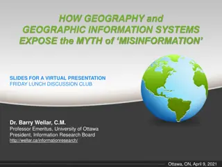
Exposing the Myth of Misinformation Through Geography and GIS
Geography and Geographic Information Systems play a crucial role in debunking the myths of misinformation. Dr. Barry Wellar discusses the impact of misinformation, highlighting the importance of geographic data in transforming information and knowledge. The presentation delves into the reasons behin
0 views • 17 slides

Tongue Disorders: Ankyloglossia, Black Hairy Tongue, Geographic Tongue
Ankyloglossia, also known as tongue-tied, is a congenital anomaly affecting tongue mobility. Black hairy tongue is the lengthening of papillae on the tongue surface, often temporary and resolve without treatment. Geographic tongue presents as white patches and is usually asymptomatic. Treatment opti
0 views • 10 slides
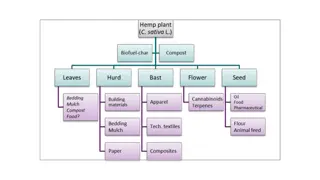
Insights into Global Hemp Crop Areas and Production Trends
Explore data on hemp crop areas and production trends worldwide, excluding North America. The visual representation showcases the distribution of hemp cultivation areas, production percentages by country, Australian industrial hemp production areas, product yields per hectare, and world natural fibe
0 views • 6 slides
Geographic Information Systems: GIS in Statistics and INSPIRE Reporting Obligations
This document outlines the agenda and practical details for a GIS workshop focusing on statistical production and data processing related to geographic information systems. It includes sessions on population gridded data production, automation processes, and practical exercises. Participants from va
2 views • 5 slides
Geographic Data Analysis in Health Statistics Conference
The 2010 National Conference on Health Statistics explored the use of restricted data at the National Center for Health Statistics Research Data Center. The presentation delved into the types of data requested, including small geographic areas, sensitive information, mortality files, and genetic dat
0 views • 45 slides
Polar Curves: Intersections, Areas, and Calculating Enclosed Areas
Explore polar curves, their intersections, areas enclosed by curves, and calculating enclosed areas using given equations. Learn to sketch graphs, find points of intersection, polar coordinates, and apply formulas for finding enclosed areas with examples provided.
0 views • 21 slides
Childhood Flu Immunisation Programme 2013/14 Pilot Feedback: Summary and Recommendations
The Childhood Flu Immunisation Programme of 2013/14 was piloted across various geographic areas in England to assess its setup, delivery, and impact. The program aimed to extend flu immunisation to children aged two to less than 17 years, providing important protection to children and indirect prote
0 views • 18 slides
Overview of the U.S. Federal Statistical System and Census Geography
The U.S. Federal Statistical System comprises 13 principal statistical agencies responsible for collecting and analyzing data across various sectors. The system includes agencies like the Bureau of Economic Analysis, Bureau of Labor Statistics, and U.S. Census Bureau. Geographic identifiers (GEOIDs
0 views • 94 slides
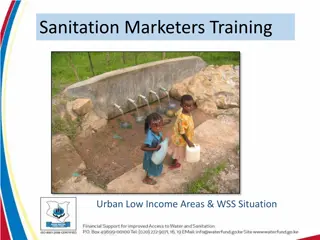
Target Areas for Sanitation Marketers Training in Urban Low-Income Areas
Target areas for sanitation marketers training in urban low-income areas include informal settlements, planned urban areas with low-income housing, informal housing in planned residential areas, urban IDP settlements, and urban sub-centers. These areas present challenges with water supply and sanita
0 views • 18 slides
Assessing Forest Loss in Protected Areas: A Philippines Case Study
The study assesses forest cover loss in terrestrial protected areas of the Philippines, analyzing the extent and rate of deforestation using Hansen's Global Forest Cover Change datasets. The research aims to understand the drivers of deforestation in protected areas, comparing forest loss in the ent
0 views • 24 slides

Geographic Concepts Explained with Visuals
Explore various geographic concepts such as time zones, latitude, albedo, environmental spheres, and interactions between spheres through informative images and descriptions. Topics include longitude measurements, Tropic of Cancer location, hemispheres identification, time zone differences, environm
0 views • 34 slides

Meeting the Challenge of Diabetes in China: Prevalence, Trends, and Geographic Variances
This comprehensive study examines the prevalence, trends, and geographic variances of diabetes in China compared to the United States. With a focus on diabetes and prediabetes rates, the analysis spans over two decades, highlighting the significant burden of the disease in the Chinese population. Th
1 views • 24 slides
Geographic Coordinates: Importance and Significance
Explore the significance of geographic coordinates in oceanography and ecosystems. Learn why wind plays a crucial role in various oceanographic disciplines. Discover how latitude and longitude are utilized to pinpoint locations on Earth's surface, whether using degrees, minutes, seconds or decimal d
0 views • 31 slides
Impact Areas and Measurement of ICT-Enabled Public Services for Migration
This content discusses the impact areas of ICT-enabled public services for migration, highlighting the desired impacts such as employment, accommodation, health, social integration, and more. It delves into how these impacts are measured using questionnaires and estimation techniques. Specific focus
0 views • 11 slides
LEADER Programme and Sub-Regional Areas in Ireland
LEADER Programme in Ireland is a key element of the Rural Development Policy 2021-2025, focusing on bottom-up, community-led approaches for rural development. It is delivered across 28 sub-regional areas, excluding main cities, through Local Action Groups implementing Local Development Strategies. S
0 views • 16 slides

Geographic Features: From Oceans to Volcanoes
Discover the diverse range of geographic features, from vast oceans and intricate coral reefs to winding rivers and dense forests. Learn about intriguing formations like peninsulas, isthmuses, and straits, and delve into natural wonders like sinkholes and wetlands. From coastal regions to volcanic l
0 views • 29 slides
Maximizing Efficiency Through GIS in the 2013 Population and Housing Census
The 2013 Population and Housing Census in The Gambia marked the first implementation of Geographic Information Systems (GIS) technology, streamlining data collection processes and ensuring comprehensive coverage of populated areas. GIS tools facilitated easy access to enumeration areas, data process
0 views • 5 slides
Submarine Cable Resiliency Report Update - September 2016
This update presents the final findings of Working Group 4A on Submarine Cable Resiliency, focusing on the importance of coordinating federal, state, and local agencies to mitigate risks to submarine cable infrastructure. The report highlights the critical role of regulatory coordination and geograp
0 views • 11 slides
Submarine Cable Resiliency Update and Recommendations
Working Group 4A provides updates on the status of submarine cable resiliency, highlighting the risks to infrastructure due to lack of coordination across agencies and clustering of cable routes. The group aims to enhance regulatory coordination and promote geographic diversity to ensure network res
0 views • 7 slides
Discovering Alabama's Geography: A 4th Grade History Lesson
Explore the geographic regions of Alabama and learn about its history, economy, and political landscape in this 4th-grade history lesson. Students will identify the state's border states, major geographic provinces, and natural resources through thematic maps and interactive activities.
0 views • 19 slides
Geographic Support System Initiative (GSS-I) Overview
The Geographic Support System Initiative (GSS-I) aims to enhance address data quality through partnerships with tribal, state, county, and local governments. This program involves acquiring, verifying, and geocoding address data, with a focus on improving address coverage and spatial accuracy. Reeng
0 views • 20 slides