Efficient Point Cloud Processing with Leica MultiWorx for AutoCAD/Civil 3D
Leica MultiWorx is a versatile plug-in for AutoCAD and Civil 3D that simplifies point cloud processing from Leica MS50 scans. It offers features like direct reading of scan data, custom drafting tools, advanced rendering options, and more. By integrating seamlessly with AutoCAD/Civil 3D, it enhances drafting efficiency and project management for users.

Uploaded on Sep 19, 2024 | 0 Views
Download Presentation

Please find below an Image/Link to download the presentation.
The content on the website is provided AS IS for your information and personal use only. It may not be sold, licensed, or shared on other websites without obtaining consent from the author. Download presentation by click this link. If you encounter any issues during the download, it is possible that the publisher has removed the file from their server.
E N D
Presentation Transcript
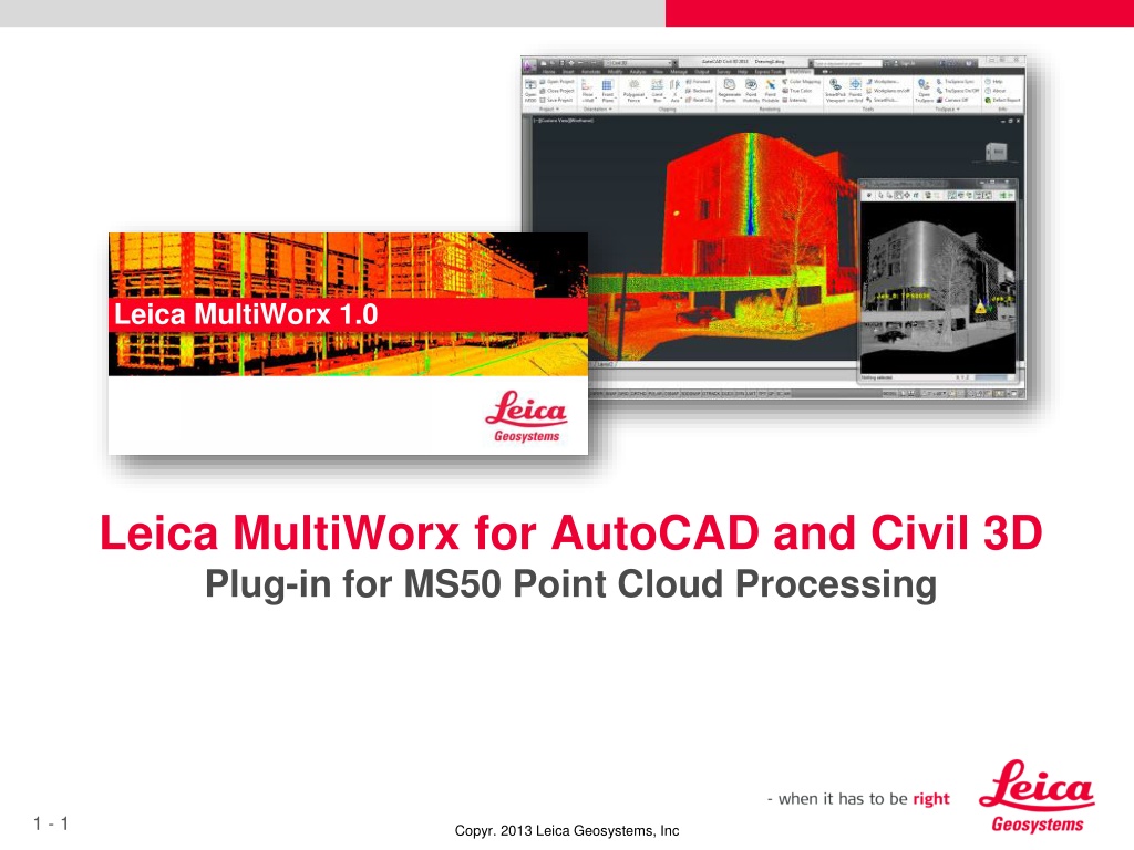
Leica MultiWorx 1.0 Leica MultiWorx for AutoCAD and Civil 3D Plug-in for MS50 Point Cloud Processing 1 - 1 Copyr. 2013 Leica Geosystems, Inc
What is Leica MultiWorx for AutoCAD and Civil 3D? Leica MultiWorx is an AutoCAD\Civil 3D plug-in for point cloud processing of Leica MS50 scan data. Users can leverage their AutoCAD expertise with an easy to learn-and-use solution for generating traditional civil drafting deliverables such as topo maps, building elevations, etc. 1 - 2 Copyr. 2013 Leica Geosystems, Inc
Unique Leica MultiWorx Product Features Direct reading of MS50 scanning project data Point clouds Images Setup information Industries best point cloud processing tools (from Leica CloudWorx) Simplified configuration for point cloud non-experts Fully leverages imaging capabilities of the MS50 instrument Includes advanced features SmartPicks capabilities (custom Osnaps for point cloud data) Unique Orientation and Drafting Workplane tools to make 2D drafting easy using 3D point cloud data Embedded in AutoCAD and Civil3D extends their basic features and ensures compatibility with existing workflows 1 - 3 Copyr. 2013 Leica Geosystems, Inc
Features Provided by MultiWorx to Enhance AutoCAD MS50 Point Cloud Data Project Management Custom Drafting Tools (Workplane) Custom Coordinate System Orientation Tools Advanced Clipping\Section Tools 3D Drafting Tools Advanced Rendering Options Imagery Integration (TruSpace) Intelligent Point Cloud Osnaps (SmartPicks) Automated Ground Survey Tools (Points-on-a-Grid) 1 - 4 Copyr. 2013 Leica Geosystems, Inc
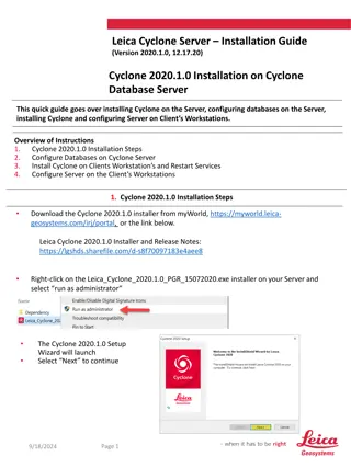
MultiWorx reads scan data directly to into CAD MultiWorx can read scan data directly from the instrument or after adjustment by Infinity (and others soon) Basic AutoCAD requires Infinity to convert the data, then another multi-step conversion and import process Scan Data Workflow Infinity Convert to PTX Leica Infinity Software Manage\Combine\Adjust AutoCAD Convert to Compatible AutoCAD Complex Import Simple One-click Import Process Basic AutoCAD\Civil 3D\Etc Leica MultiWorx Enhanced AutoCAD\Civil 3D
Project Management Simplified and Efficient Project Management This feature provides a very simple method of importing and using your MS50 project Retains project naming and setup as done in the field Much simplified and more useful compared to built-in AutoCAD method of point cloud management No data conversion required Retains project configuration Intuitive steps just open the HeXML file. One-time import makes point cloud available in any drawing See Demo Movie 1 - 6 Copyr. 2013 Leica Geosystems, Inc
Drafting on the Point Cloud Drafting on the point cloud is a simple process of using standard AutoCAD tools like Line, Polyline, Insert Block, etc. You can use the point cloud like a an image background a freehand- sketch, or use customized snapping tools. Points pickable\notpickable SmartPicks (Custom Osnaps) Highest point Lowest point Ground point See Demo Movie 1 - 7 Copyr. 2013 Leica Geosystems, Inc
3D Viewing Enhancements TruSpace TruSpace provides photo-realistic imagery and viewpoint manipulationMS50 Point Cloud Data Project Management Fully leverages MS50 camera feature Makes visualizing point clouds easy Provides unique viewpoint control capability Quick limit box features is intuitive and highly productive NO OTHER software uses MS50 images like this inside CAD See Demo Movie 1 - 8 Copyr. 2013 Leica Geosystems, Inc
Custom Orientation Tools Easy Coordinate System Control To create 2D drawings from 3D point clouds, you must manipulate the UCS (User Coordinate System) which is a standard AutoCAD capability. This can be difficult for new 3D users. The MultiWorx orientation tools provide simple tools that let you set the UCS to the cloud with just a few picks. Then you can also set the appropriate view easily to have an aligned plan view or looking straight at the face of a structure, the ground, etc. A few simple cloud picks set the UCS Easy control of viewpoint and workplane to start sketching See Demo Movie 1 - 9 Copyr. 2013 Leica Geosystems, Inc
Advanced Clipping and Sectioning Tools Powerful Productivity Tools Point clouds can be confusing or very congested. It is important to have a set of tools that lets you quickly and easily hide parts of the cloud so it is easy to concentrate the area of interest. Simple to use limit box and clipping tools Valuable productivity enhancement Not found in standard CAD environment See Demo Movie 1 - 10 Copyr. 2013 Leica Geosystems, Inc
Custom 3D Drafting Tools Custom Workplane to Simplify 2D Data extraction It can difficult to extract 2D drawings from 3D data but is a very common requirement. MultiWorx provides easy to use tools for a highly productive drafting capability. Unique workplane provides an easy to understand and use 2D drafting method Only available in MultiWorx extension even though it uses basic underlying AutoCAD capabilities See Demo Movie 1 - 11 Copyr. 2013 Leica Geosystems, Inc
Advanced Rendering Options Flexible Display Methods Ensure Best Visible Representation MultiWorx lets you optimize the display method of point cloud data to maximize the perception and usability of the data. Select Grey Scale display for a clear image that looks like a black & white photo Select false color Intensity Rainbow color to highlight details not easily seen in other colorizing methods Select True Color display to show the real world colors from photos mapped onto the point cloud instantly See Demo Movie 1 - 12 Copyr. 2013 Leica Geosystems, Inc
Custom Point Cloud Intelligent Osnaps: SmartPicks Powerful Algorithms to Enhance Productivity Custom point cloud aware Osnaps called SmartPicks provide unique and powerful capability. You pick in a general area and the SmartPick finds the could point that meets your requirements. Easy to use and understand SmartPicks make it easy to get the right point Highest point Lowest point Ground point is a specialized tool mostly used with grid based picking (see Points-on-a-grid) See Demo Movie 1 - 13 Copyr. 2013 Leica Geosystems, Inc
Automated Ground Survey Tools: Points on a Grid Powerful Automation A highly productive automated surveying tool used to collect a set of survey points most typically used for generating a ground surface\TIN. Leverages the power of the computer to survey10 s or 100 s or 1,000 s of points with a single command. Super productivity tool Do a Virtual Survey of large areas in just a few minutes that could take hours with traditional field methods See Demo Movie 1 - 14 Copyr. 2013 Leica Geosystems, Inc
Why do I need Leica MultiWorx if AutoCAD has built-in point cloud capabilities? Just like any specialized industry, AutoCAD and Civil 3D plug-ins can provide very valuable extended capabilities AutoCAD and Civil 3D currently only provide very basic viewing capabilities and very little specialized productivity tools for point cloud processing. Leica has long been the industry leader with the Cyclone and CloudWorx family of products and is still delivering capabilities years ahead of what native capabilities exist today. Leica is working very closely with Autodesk to ensure we are taking advantage of every technical opportunity and that we can continue to deliver valuable advanced features with our plug-ins 1 - 15 Copyr. 2013 Leica Geosystems, Inc
Leica MultiWorx and AutoCAD\Civil 3D Comparison Feature MultiWorx AutoCAD\Civil 3D View point clouds in AutoCAD\Civil 3D Yes Yes No, requires multi step import Open MS50 point clouds directly Yes Draw lines by picking on cloud Yes Yes Limit box\Slice tools Yes, advanced Yes, very basic Include imagery as background Yes, TruSpace No Special point cloud viewpoint control Yes, TruSpace No Special cloud based 3D orientation tools Yes No Specialized point cloud Osnaps Yes, Smartpicks Yes, Points-on-a- grid No Automated point cloud ground survey tools No 1 - 16 Copyr. 2013 Leica Geosystems, Inc
MultiWorx position in the user workflow MS50 data can be Opened in MultiWorx directly after finishing a field project Opened in MultiWorx after adjusting with Leica Infinity Opened in MultiWorx after adjustments are made by other vendors software Opened by traditional HDS\TLS scanning customers in Cyclone and CloudWorx And even if imported into Cyclone like a standard scanning project Can still be opened by MultiWorx MultiWorx can open ANY point clouds that are in Cyclone However, MultiWorx is optimized for the smaller clouds generated by the MS50 and will NOT exhibit the same performance with huge HDS point clouds as CloudWorx 1 - 17 Copyr. 2013 Leica Geosystems, Inc
MultiWorx Position in the Scanning Software Family Leica Cyclone is the leading point cloud processing software globally for high-end 3D scanner data The CloudWorx AutoCAD plug-in is a companion product that holds the leading position in CAD plugin software for point cloud processing; with thousands of users. These products are the state-of-the-art for high-end point cloud processing but can also be very complex. Leica MultiWorx has been created from CloudWorx for AutoCAD It has new simplified project management feature It has many NEW features specially developed for novice users It has specialized civil drafting features not currently found in CloudWorx It can interact with a standard Cyclone project and is 100% compatible Leica MultiWorx is part of the TLS\HDS software family and fills the new space of MS50 entry-level scanning needs 1 - 18 Copyr. 2013 Leica Geosystems, Inc
Questions? 1 - 19 Copyr. 2013 Leica Geosystems, Inc