Leveraging NASA EOS Data for Water-Related Disease Research and Response
Explore how NASA EOS data is crucial in understanding and addressing vector-borne and water-related diseases, such as malaria outbreaks. Through satellite observations, a deeper insight is gained into natural hazards' impact on public health and ecology, aiding in disaster preparedness and disease tracking. Join the initiative to bridge EO data with water-related disease applications and contribute to workshops, case studies, and user engagement efforts.

Download Presentation

Please find below an Image/Link to download the presentation.
The content on the website is provided AS IS for your information and personal use only. It may not be sold, licensed, or shared on other websites without obtaining consent from the author. Download presentation by click this link. If you encounter any issues during the download, it is possible that the publisher has removed the file from their server.
E N D
Presentation Transcript
Using EOS data to understand and respond to vector-borne and water- related disease Dorian Janney Senior Education and Outreach Specialist Dorian.w.janney@nasa.gov NASA /GSFC
Societal Benefit Areas Extreme Events and Disasters Landslides Tropical cyclones Floods Re-insurance Water Resources and Agriculture Famine Early Warning System Drought Water Resource management Agriculture Weather, Climate & Land Surface Modeling Numerical Weather Prediction Land System Modeling Global Climate Modeling Public Health and Ecology Disease tracking Food Security Animal migration
EOS DATA Applications Routine observations of precipitation and other Earth Observation measurements are fundamental to help anticipate, predict and observe disease outbreak, disasters, and more By combining data from multiple satellites and relating that to what we see from the ground, we can get a much better understanding of how natural hazards are shaping our landscape and affecting us Having the vantage point of space is invaluable for observing how are Earth is changing, but observations from the ground are CRITICAL to improving these measurements
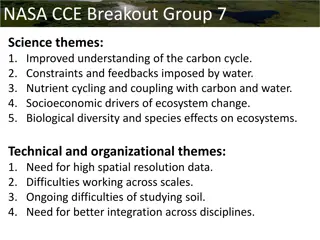
Water-related and Vector-borne Disease Initiative Scope: an effort to explore linkages and research/operational applications of NASA EOS data and water-related and vector- borne disease End Products: 1. Workshop on May 17th,2018 in Wash., D.C. 2. End user stories, interviews, case studies 3. New visualizations and NASA stories 4. Activities to engage and inform the general public 5. Online resource page with resources for general public 6. Effort to maintain networking with interested parties 7. Ongoing effort to try to make data accessible
We need help! We are looking for: -Research case studies -Engagement with end user groups -New opportunities/ideas for how we can bridge the use of EO for water-related disease applications User stories/case studies for website Needs of end users that may align with what NASA satellite data may provide We are planning: -Spring 2018 Applications-focused workshop in the DC area
Todays Program New video Using NASA Satellite Data to Predict Malaria Outbreaks (released in September) Dr. Ben Zaitchik- Early Warning System for Vector- borne Disease Risk in the Amazon Dr. Antar Jutla: Gia Mancini, Doug Gardiner, and Luisa Silva: DEVELOP Western Europe Citizen Science Mosquito Project Dorian Janney: How to Use the GLOBE Observer Mosquito Habitat Mapper and Using it to Participate in the ASTC Global Experiment