Understanding Reach Characteristics in HEC-HMS Basin Modeling

Reach characteristics play a crucial role in hydrological modeling using HEC-HMS. Georeferenced reaches are essential for computing reach characteristics like slope, sinuosity, relief, and more. The process involves pre-processing drainage data before detailed reach characteristics can be obtained. Sinuosity, slope, and relief measurements provide valuable insights into channel behavior and morphology. Check out the images and descriptions provided to grasp the significance of reach characteristics in hydrological analysis.

Download Presentation

Please find below an Image/Link to download the presentation.
The content on the website is provided AS IS for your information and personal use only. It may not be sold, licensed, or shared on other websites without obtaining consent from the author. Download presentation by click this link. If you encounter any issues during the download, it is possible that the publisher has removed the file from their server.
E N D
Presentation Transcript
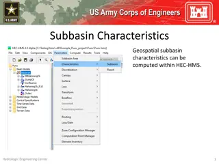
Reach Characteristics Geospatial reach characteristics can be computed within HEC- HMS. A basin model must have georeferenced reaches and the GIS | Preprocess Drainage step must be computed before reach characteristics are available. Hydrologic Engineering Center 1
Reach Characteristics Reach Slope Reach Sinuosity Reach Relief Hydrologic Engineering Center 2
Reach Characteristics Reach Slope 500ft The reach slope is calculated using the most upstream point of a reach and the most downstream point of a reach (rise/run). The tabular result is presented in standard slope format and not as a percent slope. 450ft 400ft Profile View: Reach Hydrologic Engineering Center 3
Reach Characteristics Reach Relief 500ft Reach relief represents the elevation difference between the most upstream point of a reach and its most downstream point. 450ft 400ft Profile View: Reach Hydrologic Engineering Center 4
Reach Characteristics Sinuosity Reach sinuosity is generally defined as the ratio of actual stream length to valley length. It is a descriptive measure that quantifies the degree to which a channel meanders. If the reach is perfectly straight, the reach sinuosity value will be 1. The higher the sinuosity value, the more the reach meanders and deviates from a straight path. Sinuosity = ReachLength / StraightLineLength Hydrologic Engineering Center 5