Insights from Round Robin Science Lessons Learned
Discover the latest advances in science including insights on the arctic carbon budget, disturbance quantification, vegetation changes, permafrost modeling, and remote sensing processing workflows. Dive into the complexities of carbon mapping, water dynamics, vegetation responses, and trait algorithms development for a holistic view of scientific progress.

Download Presentation

Please find below an Image/Link to download the presentation.
The content on the website is provided AS IS for your information and personal use only. It may not be sold, licensed, or shared on other websites without obtaining consent from the author. Download presentation by click this link. If you encounter any issues during the download, it is possible that the publisher has removed the file from their server.
E N D
Presentation Transcript
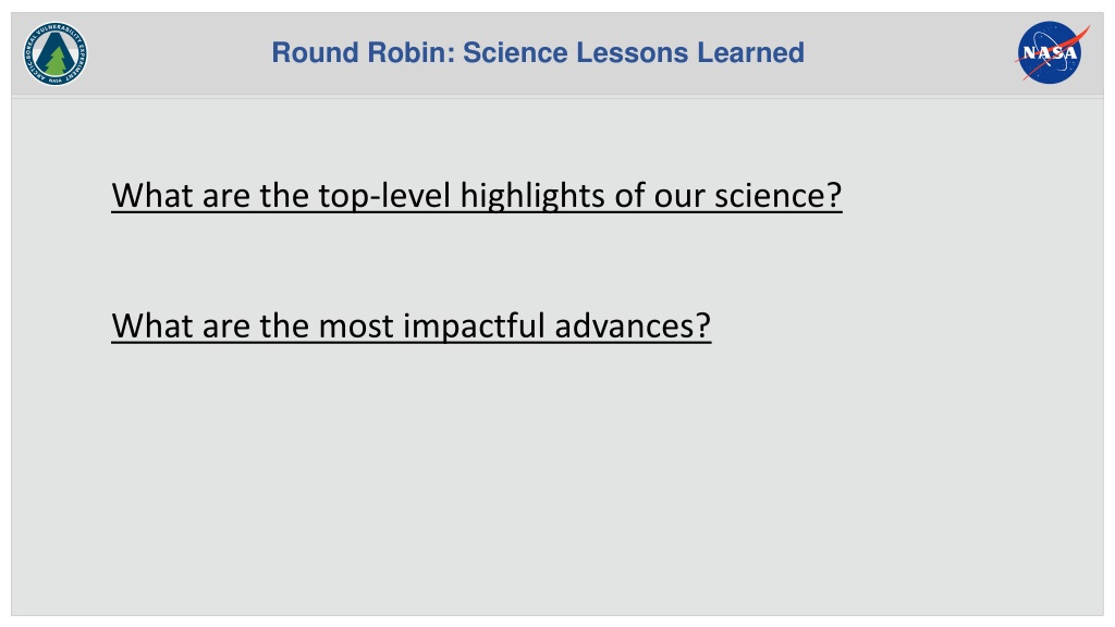
Round Robin: Science Lessons Learned What are the top-level highlights of our science? What are the most impactful advances?
Round Robin: Science Lessons Learned Science Results Carbon Grand picture of the arctic carbon budget and how it fits into the global carbon budget The high resolution of the carbon budget mapping We still don t know if the ABoVE region is a carbon source or sink Spatial variability of biomass and uncertainty how poorly constrained Diversity and importance of methane emission sources observed from aircraft Remaining uncertainty of carbon models.
Round Robin: Science Lessons Learned Science Results Disturbance Quantifying the carbon sources from burns, 2014 fires Peat fires and how they are changing The role of repeat fires Looking at disturbance and recovery Water Airborne SAR retrieval advancements including Hi res L-band data availability, active layer thickness, soil moisture, subsidence, soil carbon, biomass Know more about water location in landscape. Aircraft data for mapping Maps of soils, moisture spatial variability over the domain. Algorithm development from combination of surface measurements and aircraft data. Terrestrial water budget, how well do we know it? Know more about water location in landscape. Aircraft data for mapping
Round Robin: Science Lessons Learned Science Results Vegetation Fine scale greening and browning taking the remote sensing signal and relating it to actual changes on the ground Importance of plant functional types and biodiversity in understanding land cover change Multiyear time series (remote sensing and ground), but not yet long enough to answer some ABoVE science questions Little things matter in change, saplings, beavers, moss etc. Connecting them to the big picture. Better understand vegetation response to disturbance, below ground and above ground, from data for land surface models, need to be more specific in representation of vegetation in models. Permafrost We know what the state of the art permafrost modeling in modeling thawing of permafrost, capability of modeling it in land surface models/earth system models. Know what models include and don t include. Learning of the importance of features such as mega slumps
Round Robin: Science Lessons Learned Science Results Remote Sensing Processing workflows of AVIRIS data and development of trait algorithms. This processing allows the use of these data for consistent analyses across time and space Processing workflows of SAR data for active layer thickness, soil moisture, carbon, thaw slumps, flooding. Prepares for NISAR So many field measurements (active layer, carbon combustion, fire severity, traits) combined with satellite/aircraft observations for large scale mapping
Round Robin: Science Lessons Learned Project Results Huge baseline dataset that will be useful for decades. Covers a wide variety of data types (remote sensing and ground data) Use of remote sensing to create extensive maps of a wide variety of features The range of scales covered by the measurements Lots of ways of looking at this region, multiple people working on similar topics Improved capability to use NASA technology, More people being able to use remote sensing data. New data products, ground surveys & satellite products, that can now be used in models. New climate extremes and disturbances were observed. Defining uncertainties and need for better understanding of them Computers are faster! Data storage is greater!
Round Robin: Science Lessons Learned Project Results Connections between different groups with different focuses, Connections across different disciplines, communities Diversity of the science and cross pollination across fields So many syntheses grew out of diverse studies, Cross disciplinary combinations Bottom up organization of the experiment. Advancement of students to investigators Development of a welcoming science community The development of new and diverse science questions Targeting big questions with a lot of investigators e.g. modeling permafrost dynamics, permafrost carbon.
Round Robin: Science Lessons Learned Project Results Code of conduct Open sharing and access of data. The creation of working groups to advance synthesis science. Cross team collaboration and sharing of ideas, methods, analysis approaches, and data. Synthesis informs next NASA missions Value of transboundary work. High impact beyond science Engagement with end users Use of land guardians for quantitative and qualitative data for validation. People who collect data own the data and provide it to scientists.