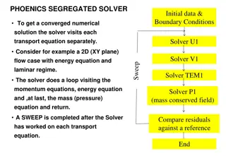
Analysis of Cloud-Resolving Simulations Over Complex Terrain
Examining cloud-resolving simulations of moist convection over complex terrain using large eddy simulation (LES) and deep convective fluxes. The study includes characteristics of the simulations, numerical convergence, and turbulent diffusion. Results reveal insights into the behavior of convective processes in mountainous regions, providing a valuable contribution to atmospheric science research.

Download Presentation

Please find below an Image/Link to download the presentation.
The content on the website is provided AS IS for your information and personal use only. It may not be sold, licensed, or shared on other websites without obtaining consent from the author. Download presentation by click this link. If you encounter any issues during the download, it is possible that the publisher has removed the file from their server.
E N D
Presentation Transcript
Bulk Convergence of Cloud-Resolving Simulations of Moist Convection over Complex terrain WOLFGANG LANGHANS, JUERG SCHMIDLI, and CHRISTOPH SCHAR J. Atmos. Sci., 69, 2207 2228.
Large eddy simulation (LES) Large eddy simulation Large eddy simulation LES 1960 Joseph Smagorinsky 80 90 sub-grid scale; SGS SGS Smagorinsky (eddy viscosity)
Bell-shaped mountain H: 10-km half-wide mountain V: 1-m high mountain L2: RMSE
General description Horizontal: 1100 990 km2 Vertical levels: 46 terrain-following Model top: 20 hPa Simulation time: 2006/07/11/0000 ~ 07/20/0600 UTC 970 km 515 km 352 km 352 km Nonhydrosatic COSMO (Consortium for Small-Scale Modeling model)
Topography LF: low-passed filtered topography (5thorder low-pass filter to the 4.4-km topography and interpolating to higher resolution)
Turbulent diffusion : vertical diffusion in NC_1D & PC_1D (100 m)
Results Basic simulation characteristics
2006/07/14/1400 UTC @ z=6km 352 km 352 km
Results Numerical convergence (NC_1D) 4.4 km ADV: advection RAD: radiative TURB: sensible heat flux convergence MIC: latent heating 4.4 km
QAM AM AM: mean flux AGS: turbulent flux TTOP: unresolved turbulent flux through top of the volume vflx= AM+AGS+TTOP
DCFs (Deep Convective Fluxs) @ z=6km
Bell-shaped mountain H: 10-km half-wide mountain V: 1-m high mountain L2: RMSE
Results Physical convergence (PC_1D)
QAM AM AM: mean flux AGS: turbulent flux TTOP: unresolved turbulent flux through top of the volume vflx= AM+AGS+TTOP
QAM AM AM: mean flux AGS: turbulent flux TTOP: unresolved turbulent flux through top of the volume vflx= AM+AGS+TTOP
DCFs (Deep Convective Fluxs) @ z=6km
@ z=6 km averaged at 1600 UTC
Summary NC1D using a fixed turbulent length scale, all bulk properties converge systematically toward the 0.55-km solution. PC is found to decrease systematically with smaller grid spacings, a less obvious physical convergence behavior was found for the PC3D. PC3D closure is explained by an increased latent heat release that balances the decreased turbulent heat entrainment with higher resolution. Surface precipitation decreases continuously with higher resolution for PC1D. PC3D closure did not involve an increased resolution sensitivity of the net heating/moistening and of surface precipitation. The consideration of one single synoptic episode domainted by thermally driven orographic convection.

")


")


")


")