Scientific Web Apps for Barrow Community Development Project
"In this project, new web mapping applications are being developed for the Barrow community to aid decision-making on topics like climate change, coastal erosion, and sustainable development. Funded by the federal Coastal Impact Assessment Program, the initiative aims to expand environmental decision-making capabilities in Ukpeaḷvik Iupiat Corporation lands. Objectives include creating high-resolution wetlands maps, developing erosion monitoring tools, and enhancing local mapping capacity. The team comprises Lars Nelson, Qaiyaan Aiken, Craig Tweedie, Allison Gaylord, and William Manley."
- Scientific Research
- Community Development
- Web Applications
- Environmental Decision-Making
- Climate Change

Download Presentation

Please find below an Image/Link to download the presentation.
The content on the website is provided AS IS for your information and personal use only. It may not be sold, licensed, or shared on other websites without obtaining consent from the author. Download presentation by click this link. If you encounter any issues during the download, it is possible that the publisher has removed the file from their server.
E N D
Presentation Transcript
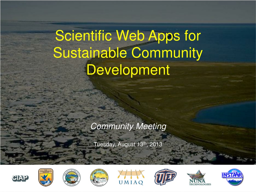
Scientific Web Apps for Sustainable Community Development Community Meeting Tuesday, August 13th, 2013
Introduction New Project Barrow Area Decision Support Tools New web mapping applications to be developed for the Barrow community Map layers and tools to assist decision making With a focus on climate change, coastal erosion, landscape change, and sustainable community development Part of the Barrow Area Information Database (BAID)
Introduction Funding Funding from the federal Coastal Impact Assessment Program (CIAP)
Introduction The BAID CIAP Team Lars Nelson and Qaiyaan Aiken Craig Tweedie, postdoc, and students Allison Gaylord William Manley
Background Coastal Erosion Climate Change Development Cultural and Environmental Impacts
Background Goal Expand capacity for informed, multi- stakeholder environmental decision making on Ukpea vik I upiat Corporation lands in the coastal zone near Barrow, Alaska.
Background Objectives 1. Create a new high-resolution map of wetlands, and conduct coastal erosion studies 1. Develop a new web mapping application to help with erosion monitoring, coastal development, and land management 1. Develop an office with newly trained staff in Barrow capable of improved local mapping and analytical capabilities
Background UIC Lands
Wetlands and Coastal Erosion New Landcover Map Layer NPR-A Landcover new 2013 data layer higher resolution entire UIC area wetlands and other land cover classes
Wetlands and Coastal Erosion New Satellite Imagery 2002 QuickBird imagery new 2013 WorldView-2 imagery higher resolution entire UIC area basis for wetlands map and coastal erosion studies
Wetlands and Coastal Erosion Coastal Erosion Analysis add new shorelines analyze rates of erosion identify areas of greatest impact
Web Mapping Application Improve upon the old BAID new fast, stable, and intuitive interface more map layers more functionality decision making tools
Web Mapping Application Targeted Web Map Apps Embedded tabs or tools : Time Slider, Erosion, Development Easy to use Visualize, save, print, and more Provide for informed decision making
Web Mapping Application Existing Development & Land Ownership parcels
Web Mapping Application Proximity to Eroding Shorelines distance from 2002 shoreline
Web Mapping Application Height Above Sea Level Elevation Contours
Wetlands and Coastal Erosion New Digital Elevation Model acquired by USGS in 2010 higher resolution coastal areas valuable for a variety of analyses USGS LIDAR DEM
Wetlands and Coastal Erosion Historic Imagery 1948
Wetlands and Coastal Erosion Historic Imagery 1955
Wetlands and Coastal Erosion Historic Imagery 1962
Wetlands and Coastal Erosion Historic Imagery 1964
Wetlands and Coastal Erosion Historic Imagery 1979
Wetlands and Coastal Erosion Historic Imagery 1997
Wetlands and Coastal Erosion Historic Imagery 2002
Local Expertise & Capacity One of the goals of the BAID Project is to build local GIS Capacity
Local Expertise & Capacity UMIAQ Lars Nelson General project management & coordination, GIS Qaiyaan Aiken GIS technician hardware, software, training, improved local GIS capacity
Local Expertise & Capacity Handbook and Outreach Advisory Council and community presentations Training for implementation Decision Support Tools Handbook facilitate long-term, community-wide use of BAID
Feedback Development of this resource is just beginning
Feedback Development of this resource is just beginning Feedback and guidance at this early stage is critical to ensure it will be helpful.
Feedback Development of this resource is just beginning Feedback and guidance at this early stage is critical to ensure it will be helpful. Useful?
Feedback Development of this resource is just beginning Feedback and guidance at this early stage is critical to ensure it will be helpful. Useful? Specific recommendations for the tools?
Feedback Development of this resource is just beginning Feedback and guidance at this early stage is critical to ensure it will be helpful. Useful? Specific recommendations for the tools? Where are the most important areas?
Feedback Development of this resource is just beginning Feedback and guidance at this early stage is critical to ensure it will be helpful. Useful? Specific recommendations for the tools? Where are the most important areas? What would you like to see?
Next Steps Field research Phased software development iterative process periodic opportunities for stakeholder feedback a focus on tool development and refinement Advisory Council meetings Community presentations
Additional Feedback Appreciated Visit: baid.utep.edu Email: Lars.Nelson@UICUmiaq.com This study is funded with qualified outer continental shelf oil and gas revenues by the Coastal Impact Assistance Program, Fish and Wildlife Service, U.S. Department of the Interior.