Understanding Penck's Cycle of Erosion in Geomorphology

Walther Penck introduced an alternative model to Davisian cycle, emphasizing the interplay between upliftment and erosion rates in landscape formation. Penck's concept focuses on relative intensity of degradation processes, phase of upliftment, and rates of erosion, rejecting the idea of stages in landscape evolution. This model highlights the continuous nature of upliftment and degradation, with landforms reflecting the relationship between these processes. The Penckian model challenges traditional views and offers a dynamic perspective on landscape development.

Download Presentation

Please find below an Image/Link to download the presentation.
The content on the website is provided AS IS for your information and personal use only. It may not be sold, licensed, or shared on other websites without obtaining consent from the author. Download presentation by click this link. If you encounter any issues during the download, it is possible that the publisher has removed the file from their server.
E N D
Presentation Transcript
GOVERNMENT COLLEGE FOR WOMEN (AUTONOMOUS) KUMBAKONAM DEPARTMENT OF GEOGRAPHY I M.Sc - GEOGRAPHY APPLIED GEOMORPHOLOGY CYCLE OF EROSION - PENCK
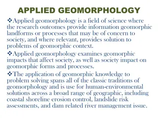
UNIT: IV UNIT: IV APPLIED GEOMORPHOLOGY APPLIED GEOMORPHOLOGY - - P18GC101 CYCLE OF EROSION CYCLE OF EROSION P18GC101 Definition of CYCLE OF EROSION By PENCK: According to Penck landform development should be interpreted by means of ratios between diastrophic processes (endogenetic, or rate of uplift) and erosional processes (exogenetic, or rate of vertical incision). Penck is supposed to have deliberately avoided the use of stage concept in his model of landscape development either to undermine the cyclic concept of W. M. Davis or to present a new model.
Cycle Of Erosion By Penck Introduction: German scientist Walther Penck rejected the Davisian model of Geomorphological cycle based on time. He presented his own model of Morphological system or Morphological Analysis for the explanation of landscape development. Penck criticised the assumption of Davis s cycle of erosion. Davis told that erosion starts only after completing the upliftment of the land mass and within very short period time. Penck also expressed disagreement with the stage concept of Davis.
According to Penck the landscape is the result of relative intensity of the degradational process, phase and rate of upliftment. It means, the landforms are determined by the rates of upliftment and the rates of erosion. In the place of stage penck used the term Entwickelung means development. Penck used the term Primarumpf to represent the characteristic landscape before upliftment. According to penk Primarumpf is an initial surface or a primary peneplain that either newly emerged surface from below sea-level or peneplain type of landscape, converted into featureless landmass by upliftment. Penck has said that the upliftment and degradation is a continuous process. He also said that the landforms are an expression of the phase and rates of upliftment in relation to the rates of degradation.
The landscape started to develop with the upliftment of primarumpf, a unique featureless landscape. But the rate of upliftment is varying. In the beginning the uplift is characterised by exceedingly slow upheaval of long duration. Then the rate of upliftment is accelerated and ultimately it stops after passing through the intermediate phases of uniform and decelerating rates and upheaval. Basic premises of penckian model: Following are the basic premises of penckian model of landscape development. The morphological characteristics on the earth surface is a result of competition between crustal movement and denudational process. Landscape development is also time dependent. Upliftment and erosion are always co-existent. There are three phases through which landscape development passes.
Aufsteigende Entwickelung: This phase is characterised by accelerating rate of landform development. Initially the rate of upliftment of land is very slow but after sometime rate of upliftment increases. Due to increase of upliftment, channel gradient also increases that leads to increase the flow velocity and kinetic energy of the river. Thus river started to degrade their valley with accelerated rate of down cutting. But the rate of upliftment is more than the valley deepening, resulted to formation of deep and narrow V shaped valley. As the rate of upliftment is more than the valley deepening by river thus, increasing both maximum altitude and maximum relief.the valley side slope become convex, but this convexity is reduced due parallel retreat of the slope. With the passage of time and accelerated upliftment and degradation Primarumpf is surrounded by series of benches, called as Piedmont trappen .
Gleichformige Entwickelung: it means uniform development of landscape. This phase is divided into three 3 phases. Phase a: This phase is also characterised by accelerating rate of upliftment . Absolute height is also increasing, because the rate of erosion is still lower than the upliftment. But the relative height is increasing in lower rate. Because, the rate of valley deepening and lowering of summit due to weathering became equal. The valley sides attained straight slope. Thus this phase is called the phase of uniform development. Phase b: Absolute relief neither increases nor decreases. Though the rate of upliftment is still continuies, but the lowering of divide summits due to denudation become equal to the rate of valley deepening by river. Thus, relative relief also remain constant.
Phase c: This phase is characterised by totally absence of upliftment of landscape. Now landscape started to decreasing in height due to rapid rate of erosion. Relative relief also remain constant. Because, the lowering of land became equal to valley deepening by the river. Absteigende Entwickelung: it means wanning development of the landscape. This phase is characterised by progressively decline of landscape. Absolute relief decreases rapidly because absence of upliftment of the land. This phase is dominated by lateral erosion instead of down cutting by the river,due to decrease in channel gradient and kinetic energy of the river. Thus the relative relief also decreases.
In this phase the valley side slope consists of two segments. The upper most part of the valley with its steep angle, termed as Gravity Slope or Boschungen. Where as the lower segment of the valley with gentle slope is termed as Wash slope or Haldenhang. In the advance stage of this phase the gravity slope are reduced and formed a steep side conical hill, called inselberg. Eventually this inselberg also consumed and total area dominated by a series of concave wash slope. Such extensive surface produced at the end of this phase is called Endrumpf.
IInd Method - PENCK Theory Walter Penck was a German geographer, he studied the Davis erosional cycle model and agreed the most of Davis's thought, but disagreed on process and stages components ( i.e trio of Davis are the structure, process, and stages) of Davis erosional model. Penck rejected that stage is not sequential and there may be interrupted by rejuvenation. Walter Penck gave a morphological system model in 1924 also known as the cycle of erosion. As per Walter Penck, the Endogenic force also interferes with the cycle of erosion through Rejuvenation. Hence, the erosion cycle is a never-ending process. The erosional cycle is not time-dependent as Davis proposed.
Rejuvenation: Through rejuvenation, the cycle is returned back from the old stage to young stages. Rejuvenation can be through two processes: Lowering the base level Upliftment of landforms. Penck Trippen Concept: First: Erosional landforms Second: Transportation Third: Depositional landforms. Graded slope: It has three parts: Zone of erosion Zone of transportation Zone of deposition As per Penck, Zone of erosion will be on the convex and free face. The zone of transportation will be on a rectilinear slope. The zone of deposition will be on a concave slope.
As per Penck: Slope retreat parallels from the convex and free face and meets together at conclave slope. Parallel retreat on free face slope. Acute erosion in convex slope Not much erosion in rectilinear slope, only transportation of erosion material takes place. On the conclave slope deposition, eroded material deposited. Later stage, free face, and convex slopes converted to the rectilinear slope.
As per Walter Penck: There are five stages in erosional cycle. Primarampf Aufteingend Gleichforminge Absteigende Endrufmpf Primarumpf: As per Penck, initially, there is a featureless surface that Penck called "Primarumpf" or primary Pedeplain. It is a prior stage of landform development. In this stage, a landscape with no landforms development. No mountain, no mountain in this stage. The upper curve and the lower curve is the same.
Gleichforminge: Three-part in this stage In the first part, uplifting is greater than erosional The highest peak will be formed in the upper curve. Second part upliftment and erosional nearly the same. Last parts, upliftment lasted and loosing slowly both valley and mountain. Absteigende: Summit or upper curve erodes faster. The river becomes graded and reaches rectilinear slope development. Formation of conical shape Inselburge. Aufteingend: Landforms start developing. Mountain are suddenly rising Valleys are deepening hence narrow valleys are created. Relief increase and convex and free face slope developed. A gap of the upper curve and the lower curve is increasing. Endogenic force> Exogenic force.
Endrumpf: Landform development stops. Pediplain developed Upperparts erosional and lower part deposition. What is inselbergs? In the third stage of Penck landform development, due to parallel retreating of the slope, at the last phase steep colonial hill formed, is called inselbergs.
IIInd Method - PENCK Theory According to O.D. Von Engeln (1960) Penck found escape from the concept of cyclic change marked by the stages youth, maturity and old age. In the place of stage he used the term entwickelung meaning thereby development. Thus, in the place of youth, maturity and old stages he used the terms aufsteigende entwickelung (waxing or accelerated rate of development), gleichformige entwickelung (uniform rate of development) and absteigende entwickelung (wanning or decelerating rate of development). Penck used the term primarumpf to represent the characteristic landscape before upliftment. Primarumpf is, in fact, initial surface or primary peneplain representing either newly emerged surface from below sea level or a fastenbene or peneplain type of land surface converted into featureless land- mass by uplift.
According to Von Engeln (1942) the primarumpf is a primary peneplain, one which could, in either case, exhibit truncated beds and structures, and yet need never have had a greater altitude or a higher relief. In other words, primarumpf is the initial landscape with evidences of erosion but with low altitude. Contrary to the concept of W.M. Davis, that landscape is a function of structure, process and time (stage) , Walther Penck postulated that, geomorphic forms are an expression of the phase and rate of uplift in relation to the rate of degradation.
It is assumed that interaction between the two factors, uplift and degradation, is continuous. The landforms observed at any given site give expression to the relation between the two factors (uplift and degradation) that has been or is in effect, and not to a stage in a progressive sequence . The landscape development (we may say the cycle of erosion) begins with the upliftment of primarumpf (initial landscape with low height and relief) representing an initial featureless broad land surface. In other words, primarumpf is initial geomorphic unit for the beginning of the development of all sorts of landforms. Penck is supposed to have assumed varying rates of upliftment of primarumpf for the development of landforms.
In the beginning the uplift is characterized by exceedingly slow upheaval of long duration and thereafter the rate of uplift is accelerated and ultimately it stops after passing through the intermediate phases of uniform and decelerating rates of upheaval. In fact, the most tectonic movements began and ended slowly, and that the common pattern of such movements involved a slow initial uplift, an accelerated uplift, a deceleration in uplift and, finally, quiescence . The initial uplift begins with regional updoming and the landform development passes through the following three phases:
(1) Aufsteigende Entwickelung: Aufsteigende entwickelung means the phase of waxing (accelerating) rate of landform development. Initially, the land surface rises slowly but after some time the rate of upliftment is accelerated. Because of upliftment and consequent increase in channel gradient, flow velocity and kinetic energy and of course increase in discharge (not due to uplift) the rivers continue to degrade their valleys with accelerated rate of down-cutting (valley deepening or incision) but the rate of upliftment far exceeds the rate of valley deepening (say degradation of uplifted landmass). Continuous active downcutting and valley deepening results in the formation of deep and narrow V shaped valleys. As the rate of uplift (aufsteigende entwickelung) continues to increase the V shaped valleys are further deepened and sharpened. Since valley deepening does not keep pace with the upliftment of landmass the absolute height continues to increase.
In other words, the altitudes of divide summits as well as the altitudes of valley bottoms continue to increase as the rate of upliftment far exceeds the rate of vertical erosion (fig. 16.2) but the relative or available reliefs continue to increase due to ever-increasing rate of vertical erosion or valley deepening. Thus, both maximum altitude (absolute height from sea level) and maximum relief (relative) increase (1 in fig. 16.2). The slopes of valley sides are convex in plan. The valley side slopes are continuously steepened due to continued valley deepening. The radius of convexity of slopes is reduced with passage of time due to parallel retreat of the steeper slope segments. With the passage of time and more accelerated uplift and degradation the primary peneplain or say primarumpf is surrounded by a series of benches called as piedmont treppen. Each of such benches develops as a piedmont flat, called in German as piedmontflache on the slowly rising margins of the dome.
(2) Gleichformige Entwickelung: Gleichformige entwickelung means uniform development of landforms. This phase may be divided into 3 subphases on the basis of rate of uplift and degradation (2 in fig. 16.2). Phase (a): Is characterized by still accelerated rate of uplift. Absolute height still increases because the rate of erosion is still less than the rate of upliftment. Altitudes of both summits of water divides and valley floors continue to increase but at relatively lower rate than in the phase of Aufsteigende entwickelung. Maximum altitude (absolute relief) is attained but relative relief remains constant because the rate of valley deepening equals the rate of lowering of divide summits. The valley sides are characterized by straight slopes This phase is called the phase of uniform development probably because of uniform rate of valley deepening and lowering of divide summits.
Phase (b): Altitude (absolute relief) neither increases nor decreases i.e. remains constant due to matching of upliftment by the lowering of divide summit due to denudation. It means that upliftment still continues. Relative relief also remains constant because the rate of erosion of divide summits matches with the rate of valley deepening while both are uplifted uniformly. The slopes of valley sides are still straight as in phase 2a because of parallel retreat. This phase is, thus, characterized by constant absolute and relative reliefs and thus uniform development of landforms. Phase (c): Upliftment of the land stops completely. Absolute reliefs or altitudes of summit divides start decreasing because of absence of upliftment but continued erosion of summits of divides. Relative reliefs also remain constant because the rate of the lowering of divide summits equals the rate of valley deepening. Thus, this subphase is also characterized by uniform development of landscape.
(3) Absteigende Entwickelung: Absteigende entwickelung means wanning development of landscape during which the landscape is progressively dominated by the erosional process of lateral erosion and consequent valley widening and marked decrease in the rate of valley deepening through vertical downcutting. This phase is marked by progressive decline of landforms. Absolute relief (altitude from sea level) decreases remarkably because of total absence of upliftment but continued downwasting of divide summits. Relative relief also decreases because the divide summits are continuously eroded down and lowered in height while downcutting of valley floor decreases remarkably due to decrease in channel gradient and kinetic energy. Parallel retreat of valley side slopes still continues.
Now the valley side slope consists of two segments. The uppermost segment main- tains its steep angle inspite of continuous lowering of ridge crests. This slope is called gravity slope or boschungen. The lower segment of the valley sides is called wash slope or haldenhang. Haldenhang, composed of talus materials of lower inclination, is formed at the base of the valley sides due to rapid parallel retreat of gravity slope or boschungen and consequent elimination of much of the convex waxing slopes. Divide summits are continuously lowered by the intersection of the retreating boschungen of adjoining valleys. Thus, the intersection of boschungen and haldenhang produces sharp knick (break in slope). Haldenhang or wash slope continues to expand at the cost of upper gravity slopes. In the advanced stage of the phase of absteigende entwickelung the gravity slopes or boschungen are reduced to steep-sided conical residuals called inselbergs
Eventually, inselbergs are also consumed and the whole landscape is dominated by a series of concave wash slopes or haldenhang. Such extensive surface produced at the end of absteigende entwickelung is called endrumpf , which may be considered equivalent to Davis peneplain. Evaluation of Penck s Model: The Penck s model of landscape development, as pointed out in the beginning, could not be correctly interpretted because of its publication in obscure German language and wrong interpretation of his ideas by English translators. Penck s morphological system was severely criticised in the USA in the same way as the geographical cycle was criticised in Germany. Penck s concepts of parallel retreat of slope and continued crustal movements became the most sensitive points of attacks by American geologists. It may be pointed out that earlier translation of Penck s work in English revealed that Penck believed in parallel retreat of slopes but subsequent English translations showed that Penck believed in slope replacement wherein each upper slope unit of hillslope and valley sides was considered to be replaced by lower slope unit of gentler slope.
It may be, thus, forwarded that most of the criticisms of Pencks morphological system came out of the faulty interpretations of his views. Some of the American critics stooped down to such an extent that they remarked that his peculiar notions owed to his incomplete recovery from a head wound suffered in World War I . His concept of long continued upliftment and tectonic speculations could not find any support but his concepts of slope development and weathering processes are definitely of much geomorphological significance.
Thank you Thank you
 KUMBAKONAM")


 the “primarumpf is a")


 Aufsteigende Entwickelung:")

 Gleichformige Entwickelung:")
:")
 Absteigende Entwickelung:")